
Alameda (island)
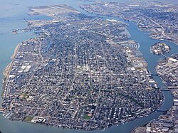
 Aerial view of the north end of Alameda Island (left), with Oakland on the right and San Francisco in the background | |
 Interactive map of Alameda Island | |
| Geography | |
|---|---|
| Location | San Francisco Bay, California |
| Coordinates | 37°46′36″N122°16′40″W / 37.77667°N 122.27778°W / 37.77667; -122.27778 |
| Coastline | 9.25 km (5.748 mi) |
| Administration | |
United States | |
| State |  California California |
Alameda Island is an island located in the San Francisco Bay in California. It is south and west of, and adjacent to, Oakland, and across the bay eastward from San Francisco. Located on the island is most of the city of Alameda, a city in Alameda County. A very small western tip of the island's territory is technically part of San Francisco; however, this is uninhabited and is not separately managed. Alameda Island is the most populated island in the continental United States that is not located in the New York City metropolitan area.
Once located on the island was the Naval Air Station Alameda, a defunct naval air station. The island was originally a peninsula and a part of Oakland and is now separated from the mainland by the Oakland Estuary. The island is connected to the mainland by six bridges: the Park Street Bridge, the Fruitvale Railroad Bridge, the Miller Sweeney Road Bridge, the High Street Bridge, the Bay Farm Island Bridge, and the Bayfarm Island Bicycle Draw Bridge. The Posey and Webster Street tubes also connect Oakland to Alameda Island.
History

เดิมทีเกาะนี้เป็นคาบสมุทรที่เชื่อมต่อกับโอ๊คแลนด์ พื้นที่ส่วนใหญ่เป็นที่ราบต่ำและเป็นหนองน้ำ แต่บนพื้นที่สูงกว่า คาบสมุทรและส่วนที่อยู่ติดกันของสิ่งที่ปัจจุบันคือใจกลางเมืองโอ๊คแลนด์เป็นที่ตั้งของป่าโอ๊คชายฝั่งที่ใหญ่ที่สุดแห่งหนึ่งของโลก ดังนั้นพื้นที่นี้จึงถูกเรียกว่าEncinalซึ่งเป็นภาษาสเปนแปลว่า "ป่าโอ๊ค" ส่วน Alamedaเป็นภาษาสเปนแปลว่า "ป่าต้นป็อปลาร์" หรือ "ถนนที่มีต้นไม้เรียงราย" [ 1 ]และได้รับการเลือกในปี พ.ศ. 2396 จากการลงคะแนนเสียงของประชาชน[ 2 ]
ในสมัยที่ชาวสเปนเข้ามาปกครองในช่วงปลายศตวรรษที่ 18 ผู้ที่อาศัยอยู่ในบริเวณนี้คือ ชนเผ่า โอห์โลน กลุ่มหนึ่ง คาบสมุทรแห่งนี้กลายเป็นส่วนหนึ่งของไร่ซานอันโตนิโอ อันกว้างใหญ่ ซึ่งได้รับพระราชทานจากอุปราชภายใต้พระเจ้า เฟอร์ดินานด์ที่ 7 แห่งสเปนให้แก่หลุยส์ เปราลตา การพระราชทานนี้ได้รับการยืนยันอีกครั้งโดย สาธารณรัฐเม็กซิโกใหม่เมื่อได้รับเอกราชจากสเปน
เมื่อเวลาผ่านไป สถานที่แห่งนี้กลายเป็นที่รู้จักในชื่อ Bolsa de Encinal หรือ Encinal de San Antonio [ 3 ]เกาะนี้ถูกสร้างขึ้นในปี 1902 ด้วยการเปิดคลองทางด้านทิศใต้เพื่อเพิ่มการกัดเซาะจากกระแสน้ำขึ้นลงเพื่อรักษาปากแม่น้ำทางทิศเหนือให้สะอาดสำหรับการเดินเรือ[ 4 ]มีการถมดินรอบเกาะและหยุดลงเมื่อเกาะขยายออกไปเกินเขตแดนของซานฟรานซิสโก
เกาะนี้มีบ้านสไตล์วิคตอเรียนจำนวนมากที่สร้างขึ้นในช่วงปลายศตวรรษที่ 19 และต้นศตวรรษที่ 20 เกือบทั้งเกาะได้รับการพัฒนาแล้ว มีชายหาดทอดยาวหลายไมล์ตามแนวชายฝั่งทางใต้