
Argentine Antarctic Program
Argentina was one of the twelve original signatories of the Antarctic Treaty which was signed on December 1, 1959, and came in force on 21 June 1961.
Argentina's scientific activities started at the beginning of the twentieth century when an Argentine named José María Sobral joined the Swedish South Polar Expedition (1901–1904) commanded by Otto Nordenskjold, which wintered two years in Antarctica. In 1904, W. S. Bruce, leader of the Scottish National Antarctic Expedition, turned over to Argentina the meteorological and geomagnetic observatory on Laurie Island, South Orkney Island which had been established in the previous year. Since then the observatory has been run by Argentina and is the location of the Orcadas Station. It claims to be the first permanent facility south of 60° Southern latitude.
The Argentine Antarctic Program is composed of several organizations forming the highest levels of the National Government. Logistics are provided by the Argentine Army, under the Defense Ministry, whereas all other activities are ruled by the Direccion Nacional del Antartico– ‘Instituto Anta´rtico Argentino’ of the Ministry of Foreign Affairs. The Instituto Antartico Argentino (IAA) was created under the Decree Nº 7338 on April 17, 1951, and is the first organization in the world to be exclusively devoted to Antarctic research.[1]
Mission, research and logistics
The purpose of the Argentine Antarctic Program is to support, strengthen, and increase the Argentine sovereign claims over the portion of the Antarctic continent and surrounding seas from 25W to 74 W and from 60S to the Pole.
The science program is run by the Instituto Antartico Argentino (IAA). The scientific priorities were set according to the National Antarctic Policy to investigate, understand, and preserve natural resources, to protect the environment, and to maintain the historical monuments. IAA is divided into scientific departments grouped into three major areas: Life sciences, Earth sciences, and Ocean and Atmospheric sciences.
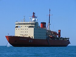
The Argentine Navy operates a large icebreaker named Almirante Irizar, an oceanographic vessel (Puerto Deseado) and several smaller patrol vessels. Air operations from South America and within Antarctica is provided by the Argentine Air Force through several C-130 Hercules planes, a small DHC-6 Twin Otter plane year round based on Marambio Station, and Bell 212 helicopters deployed in Marambio Station during the summer.[2]
Research stations
Argentina is the closest country to Antarctica and runs six permanent scientific stations, the most of any country. They are:
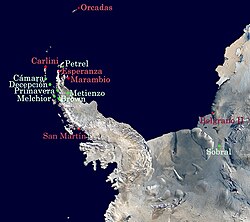
- ฐานทัพออร์คาดาส (60º44'S 44º44'W) ตั้งอยู่บนเกาะลอรี หมู่เกาะออร์กนีย์ใต้ เริ่มปฏิบัติการเมื่อวันที่ 22 กุมภาพันธ์ ค.ศ. 1904
- ฐานทัพคาร์ลินี (62º14'S 58º40'W) ตั้งอยู่บนเกาะคิงจอร์จ (25 เดอ มาโย) หมู่เกาะเซาท์เชตแลนด์ เริ่มปฏิบัติการเมื่อวันที่ 17 ธันวาคม 1952
- ฐานเอสเปรันซา (63º24'S 56º59'W) ตั้งอยู่บนอ่าวโฮป ปลายเหนือสุดของคาบสมุทรแอนตาร์กติกา เริ่มปฏิบัติการเมื่อวันที่ 17 ธันวาคม 1952
- ฐานมารัมบิโอ (64°14'S 56°38'W) ตั้งอยู่บนเกาะ Seymour (Marambio) ทางตะวันตกเฉียงเหนือของทะเล Weddell เปิดทำการเมื่อ 29 ตุลาคม 1969
- ฐานทัพซานมาร์ติน (68º08'S 67º06'W) ตั้งอยู่บนเกาะแบร์รี อ่าวมากาไรต์ เริ่มปฏิบัติการเมื่อวันที่ 21 มีนาคม 1951
- ฐาน Belgrano II (77°51'S 34°33'W) ตั้งอยู่บน Coats Land, Bertrab Nunatak, ทะเลเวดเดลล์ตะวันออกเฉียงใต้ เปิดดำเนินการเมื่อวันที่ 5 กุมภาพันธ์ พ.ศ. 2522
สถานีออร์กาดาสเป็นสถานีที่เก่าแก่ที่สุดของอาร์เจนตินาในทวีปแอนตาร์กติกา ส่วนสถานีมารัมบิโอเป็นสถานีที่ใหม่ที่สุด
นอกจากนี้ อาร์เจนตินายังมีสถานีตามฤดูกาล (ไม่ถาวร) อีกเจ็ดแห่ง:
- เรืออัลมิรันเต บราวน์ (64º52'S 62º54'W) ตั้งอยู่ที่อ่าวพาราไดซ์ เริ่มใช้งานเมื่อวันที่ 6 เมษายน 1951
- พรีมาเวรา (64°09'S 60°58'W) ตั้งอยู่บนชายฝั่ง Danco ช่องแคบ Gerlache เปิดทำการเมื่อ 8 มีนาคม 1977
- เดเซปซิออน (62°59'ใต้, 60°41'ตะวันตก) ตั้งอยู่บนอ่าวเดมาโย 1°, พอร์ตฟอสเตอร์, เกาะเดเซปซิออน, หมู่เกาะเซาท์เชตแลนด์ เริ่มดำเนินการเมื่อวันที่ 25 มกราคม 1948
- เมลคิออร์ (64°20'ใต้, 62°59'ตะวันตก) ตั้งอยู่บนเกาะแกมมาหมู่เกาะเมลคิออร์ เริ่มดำเนินการเมื่อวันที่ 31 มีนาคม 1947
- มาติเอนโซ (64°58'ใต้, 60°08'ตะวันตก) ตั้งอยู่บนเนินน้ำแข็งลาร์เซน (Larsen Nunatak) ชั้นน้ำแข็งลาร์เซน ทะเลเวดเดลล์ เริ่มปฏิบัติการเมื่อวันที่ 15 มีนาคม 1961
- คามารา (62°36'ใต้, 59°54'ตะวันตก) ตั้งอยู่บนเกาะฮาล์ฟมูน ช่องแคบแมคฟาร์เลน หมู่เกาะเซาท์เชตแลนด์ เริ่มใช้งานเมื่อวันที่ 1 เมษายน 1953
- เพเทรล (63_28 S, 56_12 W) ตั้งอยู่บนเกาะดันดี แหลมเวลช์เนส ช่องแคบแอนตาร์กติกา เริ่มปฏิบัติการในเดือนธันวาคม ค.ศ. 1952
ดูเพิ่มเติม
ลิงก์ภายนอก
 สื่อที่เกี่ยวข้องกับโครงการแอนตาร์กติกาของอาร์เจนตินาในวิกิมีเดียคอมมอนส์