
เบรสต์ อาร์เซนอล
| เบรสต์ อาร์เซนอล | |
|---|---|
 แผนที่แบบอินเทอร์แอคทีฟของสนามเบรสต์อาร์เซนอล | |
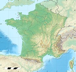  เบรสต์ อาร์เซนอล ที่ตั้งในประเทศฝรั่งเศส | |
| ที่ตั้ง | |
| ที่ตั้ง | ฝรั่งเศส |
| พิกัด | 48°23′12″N 4°29′48″W / 48.3867°N 4.4967°W / 48.3867; -4.4967 |
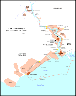
The Brest Arsenal (French: l'arsenal de Brest) is a naval base of the French Navy and a collection of naval and military buildings located on the banks of the river Penfeld, in the harbor of Brest, France.[1] It is the second French naval base after the Toulon arsenal and before the Cherbourg Naval Base.
Timeline
- 1631–1635 – Beginning of the foundations of the port infrastructure.
- 1674 – Appearance of the Powder Magazines, Cordellerie and Military Hospital.
- 1683 – Creation of the Troulan dock.
- 1746 – Creation of the three Pontaniou docks near the anchor forges and naval constructions.
- 1752 – Construction of the Bagne demolished in 1947.
- 1807 – Construction of the Bâtiment aux Lions to house the arsenal's magazines.
- 1822–1827 – Construction of Bassin 6 at the Salou.
- 1858 – Appropriation of the Tourville and Jean Bart quays by the navy.
- 1864–1865 – Construction of Bassin 7 at the Salou.
- 1865 – Closure of the Penfeld port to commercial boats, turning it into a military port.
- 1889–1896 – Construction of the South Jetty (1,500 m).
- 1895–1900 – Construction of the West Jetty (200 m).
- 1899–1902 – Transformation of the four Pontaniou docks into 2 large basins, now known as Basin 2 and Basin 3.
- 1900–1905 – South Jetty extended by 750 m.
- 1905 – Construction of the Quai d'Armement.
- 1910 – Installation of the Grande Grue.
- 1910–1916 – Digging of the two construction docks and of the Laninon dry dock, now known as Basin 8 and Basin 9.
- 1911 – Infilling of the terreplein of Brest Castle.
- 1918 – Construction of the Quai des Flottilles.
- 1931–1933 – Closure of the western passage.
- 1938 – Work begun on the construction of Bassin 10 de Laninon (work abandoned 1939–1945).
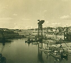
- 1940 – Construction of the Submarine Base during the German occupation - the military port became an important German strategic base.
- 1963–1964 – Jetty enlarged.
- 1969–1970 – Construction of aircraft-carrier locks 3 and 4.
Penfeld quays
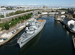
บริเวณเพนเฟลด์ภายในเขตทหารนั้น เกือบทั้งหมดเรียงรายไปด้วยท่าเทียบเรือ แต่เรือไม่สามารถเทียบท่าได้โดยตรงเนื่องจากมีโขดหินโผล่ขึ้นมาให้เห็นเมื่อน้ำลง นั่นเป็นเหตุผลที่ต้องมีการจอดเรือลอยน้ำไว้ทั้งด้านหน้าและด้านหลัง โดยส่วนใหญ่จะอยู่ทางฝั่งซ้าย เพื่อสร้างจุดจอดเรือสำหรับเรือขนาดเล็กบางลำ และสามารถใช้ประโยชน์จากสิ่งอำนวยความสะดวกต่างๆ เช่น เครนขนาดใหญ่ได้
เสา เหล่านี้ ไม่ค่อยได้ใช้งานมากนักบริเวณต้นน้ำของ สะพาน ปงต์ เดอ เรคูฟรองซ์แต่บริเวณปลายน้ำของสะพานนี้ เสาเหล่านี้ยังคงให้บริการเรือใบเก่าของกองทัพเรือ เรือลากจูงและเรือสนับสนุนอื่นๆ ของคลังแสง และเรือโดยสารที่ให้บริการข้ามอ่าวเบรสต์ ( rade de Brest ) ระหว่างเบรสต์และ คาบสมุทร โครซง ( เกาะลองเกอ , โรงเรียนนายเรือ )
ท่าเทียบเรือสำหรับจัดเตรียมอุปกรณ์ และ ท่าเทียบเรือเฉียง
ท่าเทียบเรือทั้งสองแห่งนี้ตั้งอยู่ระหว่างอ่างเก็บน้ำหมายเลข 9 และเขื่อนกันคลื่นของลานินอน โดยมีเครนให้บริการ 5 ตัว การปรับปรุงครั้งใหญ่ล่าสุดเกิดขึ้นในขั้นตอนการสร้างอ่างเก็บน้ำลานินอนขึ้นใหม่ ซึ่งการขยายความยาวของอ่างเก็บน้ำได้เปลี่ยนแปลงรูปแบบของท่าเทียบเรือเฉียงไป
ท่าเทียบเรือเหล่านี้ใช้สำหรับการตกแต่งขั้นสุดท้ายก่อนการปล่อยลงน้ำของเรือใหม่ที่สร้างในเบรสต์ (เช่นเรือมิสทรัลและเรือตองเนร์ของฝรั่งเศส ) การจอดเทียบท่าของเรือรบขนาดใหญ่ของกองทัพเรือฝรั่งเศส (เช่นเรือลาดตระเวนฌานน์ดาร์กของฝรั่งเศส ) และการบำรุงรักษาลอยน้ำของเรือทุกประเภท
ดูเพิ่มเติม
ลิงก์ภายนอก
- กองบัญชาการสูงสุดของเขตท่าเรือเบรสต์เก็บถาวรเมื่อ 24 มิถุนายน 2008 ที่Wayback Machineเว็บไซต์กองทัพเรือฝรั่งเศส
- อาร์เซนอล เดอ เบรสต์ ประเทศฝรั่งเศส