
ไบดียาปูร์
ไบดียาปูร์ | |
|---|---|
หมู่บ้าน | |
 | |
  ไบดียาปูร์ ตั้งอยู่ในรัฐเวสต์เบงกอล ประเทศอินเดีย แสดงแผนที่ของรัฐเวสต์เบงกอล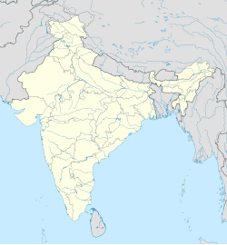 ไบดียาปูร์ ไบดียาปูร์ (อินเดีย) แสดงแผนที่ประเทศอินเดีย | |
| พิกัด: 23°09′35″N 88°14′45″E / 23.15972°N 88.24583°E / 23.15972; 88.24583 | |
| ประเทศ |  อินเดีย อินเดีย |
| สถานะ | รัฐเวสต์เบงกอล |
| เขต | ปุรบา บาร์ดามาน |
| ระดับความสูง | 12 เมตร (39 ฟุต) |
| ประชากร (2011) | |
• ทั้งหมด | 4,065 |
| ภาษา | |
| • เป็นทางการ | ภาษาเบ งกาลีภาษาอังกฤษ |
| เขตเวลา | 5:30 น. ( เวลาอินเดีย ) (UTC+1 ) |
| เข็มหมุด | 713122 |
| รหัสโทรศัพท์ | 03454 |
| เว็บไซต์ | purbabardhaman.gov.in |
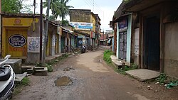
Baidyapurเป็นหมู่บ้านในบล็อกซีดีKalna II ในแผนก Kalnaของเขต Purba Bardhamanรัฐเบงกอลตะวันตกประเทศอินเดีย
ภูมิศาสตร์


[[Kalna, India]] (M)
\", \"description\": \" ([https://geohack.toolforge.org/geohack.php?params=23.23333;88.34861_dim:2000 23.23333,88.34861])\", \"marker-symbol\": \"-number-F11164166\", \"marker-size\": \"medium\", \"marker-color\": \"#800000\" }, \"geometry\": {\"type\": \"Point\", \"coordinates\": [88.34861,23.23333] } }, { \"type\": \"Feature\", \"properties\": { \"title\": \"CT
[[Srirampur, Bardhaman]] (CT)
\", \"description\": \" ([https://geohack.toolforge.org/geohack.php?params=23.40556;88.32139_dim:2000 23.40556,88.32139])\", \"marker-symbol\": \"-number-F11164166\", \"marker-size\": \"medium\", \"marker-color\": \"#a40000\" }, \"geometry\": {\"type\": \"Point\", \"coordinates\": [88.32139,23.40556] } }, { \"type\": \"Feature\", \"properties\": { \"title\": \"CT
[[Hatsimla]] (CT)
\", \"description\": \" ([https://geohack.toolforge.org/geohack.php?params=23.35833;88.32556_dim:2000 23.35833,88.32556])\", \"marker-symbol\": \"-number-F11164166\", \"marker-size\": \"medium\", \"marker-color\": \"#a40000\" }, \"geometry\": {\"type\": \"Point\", \"coordinates\": [88.32556,23.35833] } }, { \"type\": \"Feature\", \"properties\": { \"title\": \"CT
[[Jaluidanga]] (CT)
\", \"description\": \" ([https://geohack.toolforge.org/geohack.php?params=23.34167;88.34556_dim:2000 23.34167,88.34556])\", \"marker-symbol\": \"-number-F11164166\", \"marker-size\": \"medium\", \"marker-color\": \"#a40000\" }, \"geometry\": {\"type\": \"Point\", \"coordinates\": [88.34556,23.34167] } }, { \"type\": \"Feature\", \"properties\": { \"title\": \"CT
[[Gopinathpur, West Bengal]] (CT)
\", \"description\": \" ([https://geohack.toolforge.org/geohack.php?params=23.315;88.32556_dim:2000 23.315,88.32556])\", \"marker-symbol\": \"-number-F11164166\", \"marker-size\": \"medium\", \"marker-color\": \"#a40000\" }, \"geometry\": {\"type\": \"Point\", \"coordinates\": [88.32556,23.315] } }, { \"type\": \"Feature\", \"properties\": { \"title\": \"CT
[[Nasratpur]] (CT)
\", \"description\": \" ([https://geohack.toolforge.org/geohack.php?params=23.31;88.33889_dim:2000 23.31,88.33889])\", \"marker-symbol\": \"-number-F11164166\", \"marker-size\": \"medium\", \"marker-color\": \"#a40000\" }, \"geometry\": {\"type\": \"Point\", \"coordinates\": [88.33889,23.31] } }, { \"type\": \"Feature\", \"properties\": { \"title\": \"CT
[[Dhatrigram]] (CT)
\", \"description\": \" ([https://geohack.toolforge.org/geohack.php?params=23.27861;88.31333_dim:2000 23.27861,88.31333])\", \"marker-symbol\": \"-number-F11164166\", \"marker-size\": \"medium\", \"marker-color\": \"#a40000\" }, \"geometry\": {\"type\": \"Point\", \"coordinates\": [88.31333,23.27861] } }, { \"type\": \"Feature\", \"properties\": { \"title\": \"CT
[[Piarinagar]] (CT)
\", \"description\": \" ([https://geohack.toolforge.org/geohack.php?params=23.2575;88.34222_dim:2000 23.2575,88.34222])\", \"marker-symbol\": \"-number-F11164166\", \"marker-size\": \"medium\", \"marker-color\": \"#a40000\" }, \"geometry\": {\"type\": \"Point\", \"coordinates\": [88.34222,23.2575] } }, { \"type\": \"Feature\", \"properties\": { \"title\": \"CT
[[Uttar Goara]] (CT)
\", \"description\": \" ([https://geohack.toolforge.org/geohack.php?params=23.25111;88.3225_dim:2000 23.25111,88.3225])\", \"marker-symbol\": \"-number-F11164166\", \"marker-size\": \"medium\", \"marker-color\": \"#a40000\" }, \"geometry\": {\"type\": \"Point\", \"coordinates\": [88.3225,23.25111] } }, { \"type\": \"Feature\", \"properties\": { \"title\": \"CT
[[Shashpur]] (CT)
\", \"description\": \" ([https://geohack.toolforge.org/geohack.php?params=23.2125;88.37917_dim:2000 23.2125,88.37917])\", \"marker-symbol\": \"-number-F11164166\", \"marker-size\": \"medium\", \"marker-color\": \"#a40000\" }, \"geometry\": {\"type\": \"Point\", \"coordinates\": [88.37917,23.2125] } }, { \"type\": \"Feature\", \"properties\": { \"title\": \"R
[[Nadanghat]] (R)
\", \"description\": \" ([https://geohack.toolforge.org/geohack.php?params=23.37639;88.25167_dim:2000 23.37639,88.25167])\", \"marker-symbol\": \"-number-F11164166\", \"marker-size\": \"medium\", \"marker-color\": \"#c42222\" }, \"geometry\": {\"type\": \"Point\", \"coordinates\": [88.25167,23.37639] } }, { \"type\": \"Feature\", \"properties\": { \"title\": \"R
[[Purbasthali]] (R)
\", \"description\": \" ([https://geohack.toolforge.org/geohack.php?params=23.46667;88.33278_dim:2000 23.46667,88.33278])\", \"marker-symbol\": \"-number-F11164166\", \"marker-size\": \"medium\", \"marker-color\": \"#c42222\" }, \"geometry\": {\"type\": \"Point\", \"coordinates\": [88.33278,23.46667] } }, { \"type\": \"Feature\", \"properties\": { \"title\": \"R
[[Monteswar]] (R)
\", \"description\": \" ([https://geohack.toolforge.org/geohack.php?params=23.4225;88.1075_dim:2000 23.4225,88.1075])\", \"marker-symbol\": \"-number-F11164166\", \"marker-size\": \"medium\", \"marker-color\": \"#c42222\" }, \"geometry\": {\"type\": \"Point\", \"coordinates\": [88.1075,23.4225] } }, { \"type\": \"Feature\", \"properties\": { \"title\": \"R
[[Rangapara, Kalna]] (R)
\", \"description\": \" ([https://geohack.toolforge.org/geohack.php?params=23.24167;88.34083_dim:2000 23.24167,88.34083])\", \"marker-symbol\": \"-number-F11164166\", \"marker-size\": \"medium\", \"marker-color\": \"#c42222\" }, \"geometry\": {\"type\": \"Point\", \"coordinates\": [88.34083,23.24167] } }, { \"type\": \"Feature\", \"properties\": { \"title\": \"R
[[Singarkone]] (R)
\", \"description\": \" ([https://geohack.toolforge.org/geohack.php?params=23.17083;88.28583_dim:2000 23.17083,88.28583])\", \"marker-symbol\": \"-number-F11164166\", \"marker-size\": \"medium\", \"marker-color\": \"#c42222\" }, \"geometry\": {\"type\": \"Point\", \"coordinates\": [88.28583,23.17083] } }, { \"type\": \"Feature\", \"properties\": { \"title\": \"R
[[Parulia, Bardhaman]] (R)
\", \"description\": \" ([https://geohack.toolforge.org/geohack.php?params=23.44917;88.31361_dim:2000 23.44917,88.31361])\", \"marker-symbol\": \"-number-F11164166\", \"marker-size\": \"medium\", \"marker-color\": \"#c42222\" }, \"geometry\": {\"type\": \"Point\", \"coordinates\": [88.31361,23.44917] } }, { \"type\": \"Feature\", \"properties\": { \"title\": \"R
[[Atgharia]] (R)
\", \"description\": \" ([https://geohack.toolforge.org/geohack.php?params=23.27556;88.27667_dim:2000 23.27556,88.27667])\", \"marker-symbol\": \"-number-F11164166\", \"marker-size\": \"medium\", \"marker-color\": \"#c42222\" }, \"geometry\": {\"type\": \"Point\", \"coordinates\": [88.27667,23.27556] } }, { \"type\": \"Feature\", \"properties\": { \"title\": \"R
[[Badla, Purba Bardhaman]] (R)
\", \"description\": \" ([https://geohack.toolforge.org/geohack.php?params=23.15667;88.28139_dim:2000 23.15667,88.28139])\", \"marker-symbol\": \"-number-F11164166\", \"marker-size\": \"medium\", \"marker-color\": \"#c42222\" }, \"geometry\": {\"type\": \"Point\", \"coordinates\": [88.28139,23.15667] } }, { \"type\": \"Feature\", \"properties\": { \"title\": \"C
[[Samudragarh]] (C)
\", \"description\": \" ([https://geohack.toolforge.org/geohack.php?params=23.33194;88.32139_dim:2000 23.33194,88.32139])\", \"marker-symbol\": \"-number-F11164166\", \"marker-size\": \"medium\", \"marker-color\": \"#aa6666\" }, \"geometry\": {\"type\": \"Point\", \"coordinates\": [88.32139,23.33194] } }, { \"type\": \"Feature\", \"properties\": { \"title\": \"R
[[Patuli]] (R)
\", \"description\": \" ([https://geohack.toolforge.org/geohack.php?params=23.56861;88.2875_dim:2000 23.56861,88.2875])\", \"marker-symbol\": \"-number-F11164166\", \"marker-size\": \"medium\", \"marker-color\": \"#c42222\" }, \"geometry\": {\"type\": \"Point\", \"coordinates\": [88.2875,23.56861] } }, { \"type\": \"Feature\", \"properties\": { \"title\": \"H
[[Baidyapur Jora Deul]] (H)
\", \"description\": \" ([https://geohack.toolforge.org/geohack.php?params=23.15556;88.24583_dim:2000 23.15556,88.24583])\", \"marker-symbol\": \"-number-F11164166\", \"marker-size\": \"medium\", \"marker-color\": \"#000000\" }, \"geometry\": {\"type\": \"Point\", \"coordinates\": [88.24583,23.15556] } } ] } ]"}}">
หมู่บ้านนี้อยู่สูงจากระดับน้ำทะเล 12 เมตร มีที่ทำการไปรษณีย์ แต่สถานีตำรวจท้องถิ่นอยู่ที่เมืองกัลนาหมู่บ้านประกอบด้วยหลายพื้นที่ ได้แก่ รัตทาลา ราสตาลา โกลาร์ ปาร์ และนันดิปารา
การศึกษา
หมู่บ้านนี้มีโรงเรียนประถมศึกษา 2 แห่ง โรงเรียนมัธยมศึกษาตอนปลาย 2 แห่ง และโรงเรียนสำหรับคนหูหนวกและเป็นใบ้ 1 แห่ง โรงเรียนมัธยมศึกษาตอนปลายแห่งหนึ่งชื่อ Baidyapur Ramkrishna Vidyapith มีอายุมากกว่า 100 ปี ส่วนอีกแห่งคือ Baidyapur Rajrajeswar Girls' High School โรงเรียนประถมศึกษาคือ Ranjan Club & Basic School และโรงเรียนสำหรับคนหูหนวกและเป็นใบ้ชื่อ Baidyapur Bikash Bharati Muk Badhir Pratibandhi Vidyalaya
ขนส่ง
สถานีรถไฟที่ใกล้ที่สุดของไบดียาปูร์ คือสถานีโบอินชี ถนน โบอินชี - กัลนาตัดผ่านกลางหมู่บ้านนี้
ข้อมูลประชากร
ตามสำมะโนประชากรของอินเดียปี 2554 ไบเดียปูร์มีประชากรทั้งหมด 4,065 คน โดยเป็นชาย 2,049 คน (50%) และหญิง 2,016 คน (50%) ประชากรที่มีอายุต่ำกว่า 6 ปีมีจำนวน 335 คน จำนวนผู้รู้หนังสือในไบเดียปูร์ทั้งหมดคือ 3,134 คน (84.02% ของประชากรที่มีอายุมากกว่า 6 ปี) [ 1 ]
วัฒนธรรม
เทศกาลหลักของหมู่บ้านนี้คือ Rathyatra และSaraswati Puja Narkeldanga หมู่บ้านในเขตชานเมือง Baidyapur เฉลิมฉลอง Jagatgouri Jhanpan
สถานที่บูชาหลักในไบทยาปุระ ได้แก่ วัด นวรัตนะ (เก้าหอคอย) ของวรินดาบันจันทรา วัด พระศิวะของตระกูลนันดี และศาลาแกรมศิลาของราชราชేశวร[ 2 ]
เดวิด เจ. แมคคัทเชียนกล่าวถึงเดอูลแห่งเบงกอล (ค.ศ. 1598) ที่มี ลวดลาย ดินเผาบนสี่ด้าน วัดโจราศิวะและวัดศิวะของตระกูลนันดี (ค.ศ. 1802) ที่มีด้านหน้าอาคาร เป็นดินเผาอย่างหรูหรา วัดนวรัตนะที่มีบัวตรง (ค.ศ. 1845) แห่งวรินดาวานาจันทราที่มีพวงมาลัยปูนปั้น และวัดกฤษณะเด อูลคู่ที่สร้างด้วยอิฐและมีสัน(ค.ศ. 1598) ที่มีดินเผาอย่างหรูหราบนทุกด้าน เขายังกล่าวถึงดอลมันชานว รัตนะ ที่มีหอคอยทรงแจกันแบบ 'บาโรก' ที่อัมดาบาด ใกล้กับไบทยาปุระ[ 3 ]
ตามรายชื่ออนุสรณ์สถานที่มีความสำคัญระดับชาติในรัฐเวสต์เบงกอลวัดโบราณสองแห่ง (ที่เชื่อมต่อกัน) ที่ไบดียาปูร์หรือไบดียาปูร์โจราเดอุลถือเป็นอนุสรณ์สถานที่มีความสำคัญระดับชาติ[ 4 ]
การดูแลสุขภาพ
มีศูนย์สุขภาพปฐมภูมิอยู่ที่ไบดียาปูร์ (มี 15 เตียง) [ 5 ]
แกลเลอรี่
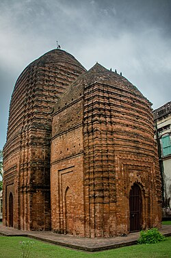 โจรา เดล
 แผ่นดินเผาที่จอราเดอุล
 วัดปัญจรัตนะ
ลิงก์ภายนอก
