
ยุทธการแห่งลัคเคา


[[Siege of Danzig (1813)]] from 16 January to 29 November 1813
\", \"description\": \" ([https://geohack.toolforge.org/geohack.php?params=54.37;18.63_dim:2000 54.37,18.63])\", \"marker-symbol\": \"-number-F654\", \"marker-size\": \"medium\", \"marker-color\": \"#000080\" }, \"geometry\": {\"type\": \"Point\", \"coordinates\": [18.63,54.37] } }, { \"type\": \"Feature\", \"properties\": { \"title\": \"2
[[Battle of Möckern]] on 5 April 1813
\", \"description\": \" ([https://geohack.toolforge.org/geohack.php?params=52.14;11.95_dim:2000 52.14,11.95])\", \"marker-symbol\": \"-number-F654\", \"marker-size\": \"medium\", \"marker-color\": \"#000080\" }, \"geometry\": {\"type\": \"Point\", \"coordinates\": [11.95,52.14] } }, { \"type\": \"Feature\", \"properties\": { \"title\": \"3
[[Battle of Lützen (1813)]] on 2 May 1813
\", \"description\": \" ([https://geohack.toolforge.org/geohack.php?params=51.22;12.18_dim:2000 51.22,12.18])\", \"marker-symbol\": \"-number-F654\", \"marker-size\": \"medium\", \"marker-color\": \"#800000\" }, \"geometry\": {\"type\": \"Point\", \"coordinates\": [12.18,51.22] } }, { \"type\": \"Feature\", \"properties\": { \"title\": \"4
[[Battle of Bautzen (1813)]] from 20 to 21 May 1813
\", \"description\": \" ([https://geohack.toolforge.org/geohack.php?params=51.18;14.42_dim:2000 51.18,14.42])\", \"marker-symbol\": \"-number-F654\", \"marker-size\": \"medium\", \"marker-color\": \"#800000\" }, \"geometry\": {\"type\": \"Point\", \"coordinates\": [14.42,51.18] } }, { \"type\": \"Feature\", \"properties\": { \"title\": \"5
[[Battle of Haynau]] on 26 May 1813
\", \"description\": \" ([https://geohack.toolforge.org/geohack.php?params=51.27;15.93_dim:2000 51.27,15.93])\", \"marker-symbol\": \"-number-F654\", \"marker-size\": \"medium\", \"marker-color\": \"#000080\" }, \"geometry\": {\"type\": \"Point\", \"coordinates\": [15.93,51.27] } }, { \"type\": \"Feature\", \"properties\": { \"title\": \"6
Battle of Luckau on 4 June 1813
\", \"description\": \" ([https://geohack.toolforge.org/geohack.php?params=51.85;13.72_dim:2000 51.85,13.72])\", \"marker-symbol\": \"-number-F654\", \"marker-size\": \"medium\", \"marker-color\": \"#000000\" }, \"geometry\": {\"type\": \"Point\", \"coordinates\": [13.72,51.85] } }, { \"type\": \"Feature\", \"properties\": { \"title\": \"7
[[Battle of Großbeeren]] on 23 August 1813
\", \"description\": \" ([https://geohack.toolforge.org/geohack.php?params=52.35;13.3_dim:2000 52.35,13.3])\", \"marker-symbol\": \"-number-F654\", \"marker-size\": \"medium\", \"marker-color\": \"#000080\" }, \"geometry\": {\"type\": \"Point\", \"coordinates\": [13.3,52.35] } }, { \"type\": \"Feature\", \"properties\": { \"title\": \"8
[[Battle of the Katzbach]] on 26 August 1813
\", \"description\": \" ([https://geohack.toolforge.org/geohack.php?params=51.1;16.1_dim:2000 51.1,16.1])\", \"marker-symbol\": \"-number-F654\", \"marker-size\": \"medium\", \"marker-color\": \"#000080\" }, \"geometry\": {\"type\": \"Point\", \"coordinates\": [16.1,51.1] } }, { \"type\": \"Feature\", \"properties\": { \"title\": \"9
[[Battle of Dresden]] from 26 to 27 August 1813
\", \"description\": \" ([https://geohack.toolforge.org/geohack.php?params=51.03;13.73_dim:2000 51.03,13.73])\", \"marker-symbol\": \"-number-F654\", \"marker-size\": \"medium\", \"marker-color\": \"#800000\" }, \"geometry\": {\"type\": \"Point\", \"coordinates\": [13.73,51.03] } }, { \"type\": \"Feature\", \"properties\": { \"title\": \"10
[[Battle of Kulm]] from 29 to 30 August 1813
\", \"description\": \" ([https://geohack.toolforge.org/geohack.php?params=50.69;13.94_dim:2000 50.69,13.94])\", \"marker-symbol\": \"-number-F654\", \"marker-size\": \"medium\", \"marker-color\": \"#000080\" }, \"geometry\": {\"type\": \"Point\", \"coordinates\": [13.94,50.69] } }, { \"type\": \"Feature\", \"properties\": { \"title\": \"11
[[Battle of Dennewitz]] on 6 September 1813
\", \"description\": \" ([https://geohack.toolforge.org/geohack.php?params=51.97;13_dim:2000 51.97,13])\", \"marker-symbol\": \"-number-F654\", \"marker-size\": \"medium\", \"marker-color\": \"#000080\" }, \"geometry\": {\"type\": \"Point\", \"coordinates\": [13,51.97] } }, { \"type\": \"Feature\", \"properties\": { \"title\": \"12
[[Battle of the Göhrde]]on 16 September 1813
\", \"description\": \" ([https://geohack.toolforge.org/geohack.php?params=53.15;10.84_dim:2000 53.15,10.84])\", \"marker-symbol\": \"-number-F654\", \"marker-size\": \"medium\", \"marker-color\": \"#000080\" }, \"geometry\": {\"type\": \"Point\", \"coordinates\": [10.84,53.15] } }, { \"type\": \"Feature\", \"properties\": { \"title\": \"13
[[Battle of Altenburg]] on 28 September 1813
\", \"description\": \" ([https://geohack.toolforge.org/geohack.php?params=50.99;12.43_dim:2000 50.99,12.43])\", \"marker-symbol\": \"-number-F654\", \"marker-size\": \"medium\", \"marker-color\": \"#000080\" }, \"geometry\": {\"type\": \"Point\", \"coordinates\": [12.43,50.99] } }, { \"type\": \"Feature\", \"properties\": { \"title\": \"14
[[Combat of Roßlau]] on 29 September 1813
\", \"description\": \" ([https://geohack.toolforge.org/geohack.php?params=51.83;12.25_dim:2000 51.83,12.25])\", \"marker-symbol\": \"-number-F654\", \"marker-size\": \"medium\", \"marker-color\": \"#000080\" }, \"geometry\": {\"type\": \"Point\", \"coordinates\": [12.25,51.83] } }, { \"type\": \"Feature\", \"properties\": { \"title\": \"15
[[Battle of Wartenburg]] on 3 October 1813
\", \"description\": \" ([https://geohack.toolforge.org/geohack.php?params=51.81;12.78_dim:2000 51.81,12.78])\", \"marker-symbol\": \"-number-F654\", \"marker-size\": \"medium\", \"marker-color\": \"#000080\" }, \"geometry\": {\"type\": \"Point\", \"coordinates\": [12.78,51.81] } }, { \"type\": \"Feature\", \"properties\": { \"title\": \"16
[[Battle of Leipzig]] from 16 to 19 October 1813
\", \"description\": \" ([https://geohack.toolforge.org/geohack.php?params=51.33;12.38_dim:2000 51.33,12.38])\", \"marker-symbol\": \"-number-F654\", \"marker-size\": \"medium\", \"marker-color\": \"#800000\" }, \"geometry\": {\"type\": \"Point\", \"coordinates\": [12.38,51.33] } }, { \"type\": \"Feature\", \"properties\": { \"title\": \"17
[[Battle of Hanau]] from 30 to 31 October 1813
\", \"description\": \" ([https://geohack.toolforge.org/geohack.php?params=50.13;8.92_dim:2000 50.13,8.92])\", \"marker-symbol\": \"-number-F654\", \"marker-size\": \"medium\", \"marker-color\": \"#800000\" }, \"geometry\": {\"type\": \"Point\", \"coordinates\": [8.92,50.13] } }, { \"type\": \"Feature\", \"properties\": { \"title\": \"18
[[Battle of Sehested]] from 10 December 1813
\", \"description\": \" ([https://geohack.toolforge.org/geohack.php?params=54.37;9.82_dim:2000 54.37,9.82])\", \"marker-symbol\": \"-number-F654\", \"marker-size\": \"medium\", \"marker-color\": \"#000080\" }, \"geometry\": {\"type\": \"Point\", \"coordinates\": [9.82,54.37] } }, { \"type\": \"Feature\", \"properties\": { \"title\": \"19
[[Siege of Hamburg]] from 24 December 1813 to 12 May 1814
\", \"description\": \" ([https://geohack.toolforge.org/geohack.php?params=53.58;9.98_dim:2000 53.58,9.98])\", \"marker-symbol\": \"-number-F654\", \"marker-size\": \"medium\", \"marker-color\": \"#000080\" }, \"geometry\": {\"type\": \"Point\", \"coordinates\": [9.98,53.58] } } ] } ]"}}">
การรบที่เมืองลัคเคาเกิดขึ้นที่เมืองลัคเคาใน รัฐบ รันเดนบูร์กเมื่อวันที่ 4 มิถุนายน ค.ศ. 1813 ระหว่างสงครามพันธมิตรครั้งที่หก กองกำลังปรัสเซียและรัสเซียภายใต้การนำของนายพลฟรีดริช วิลเฮล์ม ฟอน บือโลว์เอาชนะกองกำลังพันธมิตรฝรั่งเศสบางส่วนภายใต้การนำของจอมพลนิโคลัส อูดีโนต์[ 1 ]
พื้นหลัง
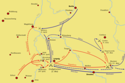
หลังจากฝรั่งเศสได้รับชัยชนะเหนือกองทัพพันธมิตรที่เบาต์เซนเมื่อวันที่ 21 พฤษภาคมนโปเลียนได้ส่งกองทัพที่ 12 ภายใต้การบัญชาการของอูดีโนต์ไปทางเหนือสู่เบอร์ลินเพื่อป้องกันการเคลื่อนไหวของบูโลว์ เมื่อวันที่ 27 พฤษภาคม หลังจากกองกำลังทั้งสองปะทะกันตาม แม่น้ำ เอลสเตอร์ดำที่ฮอยเออร์สแวร์ดากองทัพของบูโลว์ได้ถอนกำลังและกระจัดกระจายไปทางตะวันตกเฉียงเหนือไปยังยูเทอร์โบกและทางเหนือไปยังบริเวณใกล้เคียงคอตต์บุสเมื่อวันที่ 3 มิถุนายน บูโลว์ได้เคลื่อนกำลังของเขาจากคอตต์บุสไปทางตะวันตกเฉียงเหนือไปยังลัคเคาเพื่อพยายามเชื่อมต่อกับกองกำลังของเขาที่ยูเทอร์โบก เมื่ออูดีโนต์พบว่าบูโลว์เคลื่อนพลไปยังลัคเคา เขาจึงไปสกัดกั้น[ 2 ]
การต่อสู้
Oudinot บัญชาการกองทัพที่ 12และนำเฉพาะกองพลที่ 13 ของพลตรีMichel Marie Pacthod เข้าสู่การรบ หน่วยนี้ประกอบด้วยสองกองพลน้อยภายใต้ พลตรี Bernard Pourailly และพลตรี Antoine Gruyer Pourailly นำกองพันที่ 7 ของกรมทหารราบที่ 6 กองพันที่ 3 และ 4 ของกรมทหารราบที่ 7 กองพันที่ 4 ของกรมทหารราบเบาที่ 1 และกองพันที่ 4 ของกรมทหารราบที่ 10 Gruyer บัญชาการกองพันที่ 2, 3 และ 4 ของกรมทหารราบที่ 101 และกองพันที่ 1 และ 2 ของกรมทหารราบเบาเนเปิลส์ที่ 1 นอกจากนี้ยังมีกองปืนใหญ่สองกองและกองร้อยสองกองของกรมทหาร ม้าเบา บาวาเรียและเฮสเซ-ดาร์มสตัดท์ เข้าร่วมการรบด้วย [ 3 ]
กองกำลังของบูโลว์ประกอบด้วยกองพัน 16 กองครึ่ง กองร้อย 10 กอง กองทหาร ม้าคอสแซ็ก 1 กอง และปืนใหญ่ 58 กระบอก กำลังพล 15,800 นายของเขารวมถึงกองพลน้อยรัสเซียที่นำโดย พล ตรีฮาร์เป และกองพลน้อยปรัสเซียที่บัญชาการโดยเจ้าชายลุดวิก ฟอน เฮสเซ-ฮอมบูร์ก
กองหน้าของ Oudinot มาถึง Luckau เวลา 9 นาฬิกาของวันที่ 4 มิถุนายน และโจมตีทันที ในตอนแรกฝรั่งเศสผลักดันพันธมิตรกลับเข้าไปในส่วนที่มีกำแพงเมือง[ 2 ]
จากนั้นฝรั่งเศสพยายามบุกทะลวงกำแพง แต่ไม่สำเร็จ บูโลว์ฉวยโอกาสนี้ เขาเสริมกำลังทหารม้าและโจมตีปีกของฝรั่งเศส หลังจากการต่อสู้ที่กินเวลานานตลอดบ่าย อูดีโนต์ก็ถอนกำลังไป ทางตะวันตกเฉียงใต้ 40 กิโลเมตร (25 ไมล์)ไปยังอูบิเกาใกล้เดรสเดน[ 2 ] [ 3 ]
ฝ่ายรัสเซียและปรัสเซียสูญเสียทหารประมาณ 800 นาย ทั้งที่เสียชีวิตและบาดเจ็บ ส่วนฝ่ายฝรั่งเศสและพันธมิตรสูญเสียทหาร 1,500 นาย ทั้งที่เสียชีวิตและบาดเจ็บ นอกจากนี้ ทหารของบูโลว์ยังจับกุมทหารได้ 700 นาย ปืนใหญ่ 1 กระบอก และรถบรรทุกกระสุน 2 คัน[ 4 ]
ควันหลง
เมื่อวันที่ 4 มิถุนายน ค.ศ. 1813 ทั้งสองฝ่ายได้ตกลงกันใน สนธิสัญญาสงบศึกแห่งพลาสวิตซ์เป็นเวลาเจ็ดสัปดาห์ในเดือนสิงหาคม คำสั่งของนโปเลียนที่จะยึดกรุงเบอร์ลิน เมืองหลวงของปรัสเซีย นำไปสู่ยุทธการที่กรอสเบียร์เรน
การอ้างอิง
อ่านเพิ่มเติม
- "ยุทธการที่ลัคเคา" . 2002. เก็บถาวรจากต้นฉบับเมื่อวันที่ 17 สิงหาคม 2002 . เรียกดูเมื่อวันที่ 4 มิถุนายน 2021 .
ลิงก์ภายนอก
 สื่อที่เกี่ยวข้องกับยุทธการลัคเคาในวิกิมีเดียคอมมอนส์
| ก่อนหน้านั้น คือเหตุการณ์การล้อมเมืองตาร์ราโกนา (ค.ศ. 1813) | สงคราม นโปเลียน ยุทธการที่ลัคเคา | ตามมา ด้วยยุทธการที่วิโตเรีย |