
Brans
Coordinates: 47°13′59″N5°34′04″E / 47.2331°N 5.5678°E / 47.2331; 5.5678
Brans | |
|---|---|
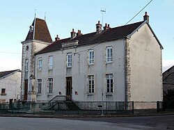 The town hall in Brans | |
 Location of Brans | |
  Brans 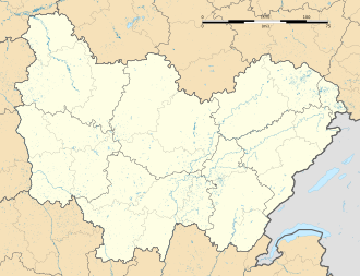 Brans | |
| Coordinates: 47°13′59″N5°34′04″E / 47.2331°N 5.5678°E / 47.2331; 5.5678 | |
| Country | France |
| Region | Bourgogne-Franche-Comté |
| Department | Jura |
| Arrondissement | Dole |
| Canton | Authume |
| Government | |
| • Mayor (2020–2026) | Michaël Peres[1] |
Area 1 | 8.77 km2 (3.39 sq mi) |
| Population (2023)[2] | 200 |
| • Density | 23/km2 (59/sq mi) |
| Time zone | UTC+01:00 (CET) |
| • Summer (DST) | UTC+02:00 (CEST) |
| INSEE/Postal code | 39074 /39290 |
| Elevation | 198–367 m (650–1,204 ft) |
| 1 French Land Register data, which excludes lakes, ponds, glaciers > 1 km2 (0.386 sq mi or 247 acres) and river estuaries. | |
Brans (French pronunciation:[bʁɑ̃]) is a commune in the Juradepartment in Bourgogne-Franche-Comté in eastern France.[3]
Population
| Year | Pop. | ±% p.a. |
|---|---|---|
| 1968 | 182 | — |
| 1975 | 166 | −1.31% |
| 1982 | 168 | +0.17% |
| 1990 | 170 | +0.15% |
| 1999 | 178 | +0.51% |
| 2007 | 214 | +2.33% |
| 2012 | 237 | +2.06% |
| 2017 | 216 | −1.84% |
| 2023 | 200 | −1.27% |
| Source: INSEE[4] | ||