
California State Route 169
 State Route 169 | ||||
|---|---|---|---|---|
 Map of northwestern California with SR 169 highlighted in red | ||||
| Route information | ||||
| Maintained by Caltrans | ||||
| Length | 23.867 mi[1] (38.410 km) SR 169 is broken into pieces due to an unconstructed portion, and the length does not reflect the gap. | |||
| Existed | 1919–present | |||
| Section 1 | ||||
| West end |  US 101 at Klamath US 101 at Klamath | |||
| East end | Klamath Glen | |||
| Section 2 | ||||
| West end | Wautec Village | |||
| East end |  SR 96 at Weitchpec SR 96 at Weitchpec | |||
| Location | ||||
| Country | United States | |||
| State | California | |||
| Counties | Del Norte, Humboldt | |||
| Highway system | ||||
| ||||


State Route 169 (SR 169) is a state highway in the U.S. state of California that is separated into two distinct segments by undeveloped areas in the Yurok Indian Reservation in Del Norte and Humboldt counties. The western segment runs from U.S. Route 101 near Klamath to Klamath Glen, while the eastern segment goes from Wautec Village to State Route 96 near Weitchpec.
Route description
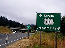

The route begins at U.S. Route 101 near Klamath and after a discontinuity from Klamath Glen (near the McBeth Airport) to Johnsons via the Yurok Indian Reservation, resumes at the town of Wautec. The highway continues through Pecwan before the curving road heads southeast and passes through Martins Ferry after several miles. SR 169 ends at State Route 96 near Weitchpec. The entire route is within the Yurok Indian Reservation.[2]
SR 169 is not part of the National Highway System,[3] a network of highways that are considered essential to the country's economy, defense, and mobility by the Federal Highway Administration.[4]
Major intersections
ยกเว้นในกรณีที่มีตัวอักษรนำหน้า ระยะทางหลักไมล์วัดจากถนนตามสภาพที่เป็นอยู่ในปี 1964โดยอิงตามแนวเส้นทางที่มีอยู่ ณ เวลานั้น และไม่จำเป็นต้องสะท้อนถึงระยะทางปัจจุบัน R แสดงถึงการปรับแนวเส้นทางใหม่นับตั้งแต่นั้นมา M แสดงถึงการปรับแนวเส้นทางครั้งที่สอง L หมายถึงส่วนที่ทับซ้อนกันเนื่องจากการแก้ไขหรือการเปลี่ยนแปลง และ T แสดงถึงระยะทางหลักไมล์ที่จัดอยู่ในประเภทชั่วคราว ( ) [ 1 ]ส่วนที่ยังไม่ได้ก่อสร้างหรือถูกโอนไปอยู่ภายใต้การควบคุมของท้องถิ่นอาจถูกละเว้น ตัวเลขจะถูกรีเซ็ตที่เส้นแบ่งเขตเทศมณฑล ระยะทางหลักไมล์เริ่มต้นและสิ้นสุดในแต่ละเทศมณฑลจะระบุไว้ในคอลัมน์เทศมณฑล
| เขต | ที่ตั้ง | Postmile [ 1 ] [ 5 ] [ 6 ] | จุดหมายปลายทาง | หมายเหตุ | |||
|---|---|---|---|---|---|---|---|
| เดล นอร์เตDN R0.00-3.52 | คลาแมธ | 0.00 บาท | ทางหลวง หมายเลข 101 ของสหรัฐอเมริกา – ยูเรกา , เครสเซนต์ซิตี้ | จุดเชื่อมต่อทางแยก; ปลายด้านตะวันตกของทางหลวงหมายเลข 169; ทางออกหมายเลข 769 ของทางหลวงหมายเลข 101; ถนนจะต่อเนื่องเป็นถนนแชปแมน | |||
| คลาแมธ เกลน | 3.52 | ถนนริฟเฟิล | ปลายด้านตะวันออกของส่วนตะวันตกของทางหลวงหมายเลข 169 | ||||
| ช่องว่างในเส้นทาง | |||||||
| ฮัมโบลด์HUM 13.20-33.84 | วอเทค | 13.20 | ถนนจอห์นสัน | ปลายด้านตะวันตกของส่วนตะวันออกของทางหลวงหมายเลข 169 | |||
| | 29.95 | สะพานมาร์ตินส์เฟอร์รีข้ามลำธารมาร์ตินส์เฟอร์รีสคูลครีก | |||||
| เวทช์เป็ก | 33.84 | เอสอาร์ 96 | ปลายด้านตะวันออกของทางหลวงหมายเลข 169 | ||||
| 1.000 ไมล์ = 1.609 กม.; 1.000 กม. = 0.621 ไมล์ | |||||||
ดูเพิ่มเติม
 พอร์ทัลถนนแคลิฟอร์เนีย
ลิงก์ภายนอก

- กรมการขนส่งแห่งรัฐแคลิฟอร์เนีย: สภาพทางหลวงหมายเลข 169
- แผนที่สภาพการจราจรของ Caltrans
- เหตุการณ์จราจรของตำรวจทางหลวงแคลิฟอร์เนีย
- แคลิฟอร์เนีย @ AARoads.com - ทางหลวงหมายเลข 169
- ทางหลวงแคลิฟอร์เนีย: SR 169