อ่าน 4 นาที
แผนที่ยานแคสสินี
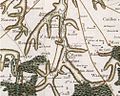
แผนที่คาสสินีหรือแผนที่ของสถาบันเป็นแผนที่ภูมิประเทศและเรขาคณิตฉบับแรกที่จัดทำขึ้นสำหรับราชอาณาจักรฝรั่งเศสทั้งหมด แผนที่นี้จัดทำโดยตระกูลคาสสินี โดยเฉพาะอย่างยิ่งเซซาร์-ฟรองซัวส์.
แผนที่ยานแคสสินี

แผนที่คาสสินีหรือแผนที่ของสถาบันเป็นแผนที่ภูมิประเทศและเรขาคณิตฉบับแรกที่จัดทำขึ้นสำหรับราชอาณาจักรฝรั่งเศสทั้งหมด แผนที่นี้จัดทำโดยตระกูลคาสสินี โดยเฉพาะอย่างยิ่งเซซาร์-ฟรองซัวส์ คาสสินี (คาสสินีที่ 3) และฌอง-โดมินิก คาสสินี (คาสสินีที่ 4) บุตรชายของเขา ในช่วงทศวรรษ 1700
เป็นการวัดในมาตราส่วนหนึ่งเส้นต่อหนึ่งร้อยหน่วยโทส์หรือก็คือ 1/86,400
แผนที่นี้ถือเป็นนวัตกรรมที่แท้จริงและเป็นความก้าวหน้าทางเทคนิคที่สำคัญในยุคนั้น เป็นแผนที่ฉบับแรกที่สร้างขึ้นโดยใช้หลักการ วัดระยะทางด้วยสามเหลี่ยม ทางภูมิศาสตร์ทีมงานของตระกูล Cassini กว่าสี่รุ่นได้ร่วมกันทำงานนี้ โดยใช้เวลากว่า 6 ทศวรรษจึงจะแล้วเสร็จ แผนที่นี้ไม่ได้ระบุตำแหน่งที่ตั้งของบ้านเรือนหรือขอบเขตของหนองน้ำและป่าไม้ได้อย่างแม่นยำ แต่ระดับความแม่นยำของเครือข่ายถนนที่แสดงนั้นสูงมาก จนเมื่อนำภาพถ่ายดาวเทียมมาซ้อนทับลงบนแผนที่ของฝรั่งเศสแล้ว จะได้ผลลัพธ์ที่น่าทึ่ง
The work of the Cassinis even left its mark on the land where today you can still find toponyms such as "Signal of Cassini." Such landmarks correspond to the corners of the triangles that formed the backbone of Cassini's map.
Nowadays, researchers frequently consult the Cassini map sheets, in its paper form in the reading room of the maps and plans department of the Bibliothèque nationale de France, or its digital form online.[1][2] It is of particular interest to archaeologists, architects, historians, geographers, genealogists, treasure hunters and ecologists who need to retrospect ecology or understand the history of landscape.
Beginnings
The genesis of the Cassini Map came during the reign of Louis XIV, with the creation of the Academy of Sciences alongside the ambitions of Jean-Baptiste Colbert for France's navy, the defence of her coasts and fixing the imprecision of the country's maps. At the time, distances between settlements to be portrayed on maps were often estimated by the time of the journey between them or by measuring the length of the road.[3] Sometimes, triangulation was used - though often relying on the magnetic pin of a compass without concern for one's latitude.[4] This would result in confounded errors when compiling these maps into one.[4]
Cassini, alongside other scientists like Picard, Roëmer and Richer, investigated movement of the planets relative to Earth. Cassini noted such methods were riddled with instrumental errors and were susceptible to parallax.[5] Picard and La Hire write in 1672 that King Louis XIV instructed the Academy of Sciences to, "create a map of all of France with the greatest precision possible.",[6] Cassini writes that in September 1672, M. Vivier had, "come by order of the King" and was, "employed by order of the King to work on the Map of the Kingdom under the direction of the Academy of Sciences."[6]
Gallery

See also
External
Online portal found here: https://www.geoportail.gouv.fr/donnees/carte-de-cassini