
ชิตาร์ปูร์
ชิตาร์ปูร์ ( หรือเขียนว่า ชิตาร์ ปูร์) เป็นเมืองตามสำมะโนประชากรใน เขตการปกครอง ชิตาร์ปูร์ในตำบลรามการ์ห์อำเภอ ราม การ์ห์ จังหวัดฌาร์ขันด์ประเทศอินเดีย
นิรุกติศาสตร์
คำว่า Chitarpur มาจากชื่อของ Chitra Devi ธิดาของมหาราชาผู้ปกครองในยุค 1700 เนื่องจากหมู่บ้านและพื้นที่ใกล้เคียงถูกมอบให้แก่เธอโดยบิดาของเธอ[ 1 ]
ภูมิศาสตร์


[[Balkundra]] (CT)
\", \"description\": \" ([https://geohack.toolforge.org/geohack.php?params=23.64194;85.32083_dim:2000 23.64194,85.32083])\", \"marker-symbol\": \"-number-F1092\", \"marker-size\": \"medium\", \"marker-color\": \"#a40000\" }, \"geometry\": {\"type\": \"Point\", \"coordinates\": [85.32083,23.64194] } }, { \"type\": \"Feature\", \"properties\": { \"title\": \"CT
[[Barkakana]] (CT)
\", \"description\": \" ([https://geohack.toolforge.org/geohack.php?params=23.61389;85.48333_dim:2000 23.61389,85.48333])\", \"marker-symbol\": \"-number-F1092\", \"marker-size\": \"medium\", \"marker-color\": \"#a40000\" }, \"geometry\": {\"type\": \"Point\", \"coordinates\": [85.48333,23.61389] } }, { \"type\": \"Feature\", \"properties\": { \"title\": \"CT
[[Ara, Ramgarh]] (CT)
\", \"description\": \" ([https://geohack.toolforge.org/geohack.php?params=23.74583;85.55556_dim:2000 23.74583,85.55556])\", \"marker-symbol\": \"-number-F1092\", \"marker-size\": \"medium\", \"marker-color\": \"#a40000\" }, \"geometry\": {\"type\": \"Point\", \"coordinates\": [85.55556,23.74583] } }, { \"type\": \"Feature\", \"properties\": { \"title\": \"CT
[[Barughutu]] (CT)
\", \"description\": \" ([https://geohack.toolforge.org/geohack.php?params=23.7875;85.5525_dim:2000 23.7875,85.5525])\", \"marker-symbol\": \"-number-F1092\", \"marker-size\": \"medium\", \"marker-color\": \"#a40000\" }, \"geometry\": {\"type\": \"Point\", \"coordinates\": [85.5525,23.7875] } }, { \"type\": \"Feature\", \"properties\": { \"title\": \"CT
[[Bongabar]] (CT)
\", \"description\": \" ([https://geohack.toolforge.org/geohack.php?params=23.70139;85.52417_dim:2000 23.70139,85.52417])\", \"marker-symbol\": \"-number-F1092\", \"marker-size\": \"medium\", \"marker-color\": \"#a40000\" }, \"geometry\": {\"type\": \"Point\", \"coordinates\": [85.52417,23.70139] } }, { \"type\": \"Feature\", \"properties\": { \"title\": \"CT
Chitarpur (CT)
\", \"description\": \" ([https://geohack.toolforge.org/geohack.php?params=23.57639;85.65472_dim:2000 23.57639,85.65472])\", \"marker-symbol\": \"-number-F1092\", \"marker-size\": \"medium\", \"marker-color\": \"#000000\" }, \"geometry\": {\"type\": \"Point\", \"coordinates\": [85.65472,23.57639] } }, { \"type\": \"Feature\", \"properties\": { \"title\": \"CT
[[Hesla, Ramgarh]] (CT)
\", \"description\": \" ([https://geohack.toolforge.org/geohack.php?params=23.61389;85.28361_dim:2000 23.61389,85.28361])\", \"marker-symbol\": \"-number-F1092\", \"marker-size\": \"medium\", \"marker-color\": \"#a40000\" }, \"geometry\": {\"type\": \"Point\", \"coordinates\": [85.28361,23.61389] } }, { \"type\": \"Feature\", \"properties\": { \"title\": \"CT
[[Jainagar, Ramgarh]] (CT)
\", \"description\": \" ([https://geohack.toolforge.org/geohack.php?params=23.66111;85.31667_dim:2000 23.66111,85.31667])\", \"marker-symbol\": \"-number-F1092\", \"marker-size\": \"medium\", \"marker-color\": \"#a40000\" }, \"geometry\": {\"type\": \"Point\", \"coordinates\": [85.31667,23.66111] } }, { \"type\": \"Feature\", \"properties\": { \"title\": \"CT
[[Kedla]] (CT)
\", \"description\": \" ([https://geohack.toolforge.org/geohack.php?params=23.78917;85.59_dim:2000 23.78917,85.59])\", \"marker-symbol\": \"-number-F1092\", \"marker-size\": \"medium\", \"marker-color\": \"#a40000\" }, \"geometry\": {\"type\": \"Point\", \"coordinates\": [85.59,23.78917] } }, { \"type\": \"Feature\", \"properties\": { \"title\": \"CT
[[Kuju, Ramgarh]] (CT)
\", \"description\": \" ([https://geohack.toolforge.org/geohack.php?params=23.725;85.51111_dim:2000 23.725,85.51111])\", \"marker-symbol\": \"-number-F1092\", \"marker-size\": \"medium\", \"marker-color\": \"#a40000\" }, \"geometry\": {\"type\": \"Point\", \"coordinates\": [85.51111,23.725] } }, { \"type\": \"Feature\", \"properties\": { \"title\": \"CT
[[Lapanga, Ramgarh]] (CT)
\", \"description\": \" ([https://geohack.toolforge.org/geohack.php?params=23.65306;85.40972_dim:2000 23.65306,85.40972])\", \"marker-symbol\": \"-number-F1092\", \"marker-size\": \"medium\", \"marker-color\": \"#a40000\" }, \"geometry\": {\"type\": \"Point\", \"coordinates\": [85.40972,23.65306] } }, { \"type\": \"Feature\", \"properties\": { \"title\": \"CT
[[Mandu, Jharkhand]] (CT)
\", \"description\": \" ([https://geohack.toolforge.org/geohack.php?params=23.79417;85.47_dim:2000 23.79417,85.47])\", \"marker-symbol\": \"-number-F1092\", \"marker-size\": \"medium\", \"marker-color\": \"#a40000\" }, \"geometry\": {\"type\": \"Point\", \"coordinates\": [85.47,23.79417] } }, { \"type\": \"Feature\", \"properties\": { \"title\": \"CT
[[Marar, Ramgarh]] (CT)
\", \"description\": \" ([https://geohack.toolforge.org/geohack.php?params=23.67833;85.50694_dim:2000 23.67833,85.50694])\", \"marker-symbol\": \"-number-F1092\", \"marker-size\": \"medium\", \"marker-color\": \"#a40000\" }, \"geometry\": {\"type\": \"Point\", \"coordinates\": [85.50694,23.67833] } }, { \"type\": \"Feature\", \"properties\": { \"title\": \"CT
[[Orla, Jharkhand]] (CT)
\", \"description\": \" ([https://geohack.toolforge.org/geohack.php?params=23.72222;85.47389_dim:2000 23.72222,85.47389])\", \"marker-symbol\": \"-number-F1092\", \"marker-size\": \"medium\", \"marker-color\": \"#a40000\" }, \"geometry\": {\"type\": \"Point\", \"coordinates\": [85.47389,23.72222] } }, { \"type\": \"Feature\", \"properties\": { \"title\": \"CT
[[Patratu]] (CT)
\", \"description\": \" ([https://geohack.toolforge.org/geohack.php?params=23.67417;85.28_dim:2000 23.67417,85.28])\", \"marker-symbol\": \"-number-F1092\", \"marker-size\": \"medium\", \"marker-color\": \"#a40000\" }, \"geometry\": {\"type\": \"Point\", \"coordinates\": [85.28,23.67417] } }, { \"type\": \"Feature\", \"properties\": { \"title\": \"CT
[[Sanri]] (CT)
\", \"description\": \" ([https://geohack.toolforge.org/geohack.php?params=23.69722;85.49694_dim:2000 23.69722,85.49694])\", \"marker-symbol\": \"-number-F1092\", \"marker-size\": \"medium\", \"marker-color\": \"#a40000\" }, \"geometry\": {\"type\": \"Point\", \"coordinates\": [85.49694,23.69722] } }, { \"type\": \"Feature\", \"properties\": { \"title\": \"CT
[[Saunda]] (CT)
\", \"description\": \" ([https://geohack.toolforge.org/geohack.php?params=23.65306;85.34722_dim:2000 23.65306,85.34722])\", \"marker-symbol\": \"-number-F1092\", \"marker-size\": \"medium\", \"marker-color\": \"#a40000\" }, \"geometry\": {\"type\": \"Point\", \"coordinates\": [85.34722,23.65306] } }, { \"type\": \"Feature\", \"properties\": { \"title\": \"CT
[[Seota]] (CT)
\", \"description\": \" ([https://geohack.toolforge.org/geohack.php?params=23.68111;85.52194_dim:2000 23.68111,85.52194])\", \"marker-symbol\": \"-number-F1092\", \"marker-size\": \"medium\", \"marker-color\": \"#a40000\" }, \"geometry\": {\"type\": \"Point\", \"coordinates\": [85.52194,23.68111] } }, { \"type\": \"Feature\", \"properties\": { \"title\": \"CT
[[Sewai]] (CT)
\", \"description\": \" ([https://geohack.toolforge.org/geohack.php?params=23.61;85.68_dim:2000 23.61,85.68])\", \"marker-symbol\": \"-number-F1092\", \"marker-size\": \"medium\", \"marker-color\": \"#a40000\" }, \"geometry\": {\"type\": \"Point\", \"coordinates\": [85.68,23.61] } }, { \"type\": \"Feature\", \"properties\": { \"title\": \"CT
[[Sirka, India]] (CT)
\", \"description\": \" ([https://geohack.toolforge.org/geohack.php?params=23.65417;85.4325_dim:2000 23.65417,85.4325])\", \"marker-symbol\": \"-number-F1092\", \"marker-size\": \"medium\", \"marker-color\": \"#a40000\" }, \"geometry\": {\"type\": \"Point\", \"coordinates\": [85.4325,23.65417] } }, { \"type\": \"Feature\", \"properties\": { \"title\": \"CT
[[Taping, Ramgarh]] (CT)
\", \"description\": \" ([https://geohack.toolforge.org/geohack.php?params=23.83556;85.49417_dim:2000 23.83556,85.49417])\", \"marker-symbol\": \"-number-F1092\", \"marker-size\": \"medium\", \"marker-color\": \"#a40000\" }, \"geometry\": {\"type\": \"Point\", \"coordinates\": [85.49417,23.83556] } }, { \"type\": \"Feature\", \"properties\": { \"title\": \"CT
[[Topa]] (CT)
\", \"description\": \" ([https://geohack.toolforge.org/geohack.php?params=23.74417;85.47556_dim:2000 23.74417,85.47556])\", \"marker-symbol\": \"-number-F1092\", \"marker-size\": \"medium\", \"marker-color\": \"#a40000\" }, \"geometry\": {\"type\": \"Point\", \"coordinates\": [85.47556,23.74417] } }, { \"type\": \"Feature\", \"properties\": { \"title\": \"M
[[Ramgarh Cantonment]] (M)
\", \"description\": \" ([https://geohack.toolforge.org/geohack.php?params=23.62222;85.51417_dim:2000 23.62222,85.51417])\", \"marker-symbol\": \"-number-F1092\", \"marker-size\": \"medium\", \"marker-color\": \"#a40000\" }, \"geometry\": {\"type\": \"Point\", \"coordinates\": [85.51417,23.62222] } }, { \"type\": \"Feature\", \"properties\": { \"title\": \"R
[[Bhadani Nagar]] (R)
\", \"description\": \" ([https://geohack.toolforge.org/geohack.php?params=23.60972;85.47222_dim:2000 23.60972,85.47222])\", \"marker-symbol\": \"-number-F1092\", \"marker-size\": \"medium\", \"marker-color\": \"#c40000\" }, \"geometry\": {\"type\": \"Point\", \"coordinates\": [85.47222,23.60972] } }, { \"type\": \"Feature\", \"properties\": { \"title\": \"R
[[Bhurkunda]] (R)
\", \"description\": \" ([https://geohack.toolforge.org/geohack.php?params=23.65639;85.36389_dim:2000 23.65639,85.36389])\", \"marker-symbol\": \"-number-F1092\", \"marker-size\": \"medium\", \"marker-color\": \"#c40000\" }, \"geometry\": {\"type\": \"Point\", \"coordinates\": [85.36389,23.65639] } }, { \"type\": \"Feature\", \"properties\": { \"title\": \"R
[[Dulmi]] (R)
\", \"description\": \" ([https://geohack.toolforge.org/geohack.php?params=23.53056;85.6025_dim:2000 23.53056,85.6025])\", \"marker-symbol\": \"-number-F1092\", \"marker-size\": \"medium\", \"marker-color\": \"#c40000\" }, \"geometry\": {\"type\": \"Point\", \"coordinates\": [85.6025,23.53056] } }, { \"type\": \"Feature\", \"properties\": { \"title\": \"R
[[Ghatotand]] (R)
\", \"description\": \" ([https://geohack.toolforge.org/geohack.php?params=23.7975;85.57444_dim:2000 23.7975,85.57444])\", \"marker-symbol\": \"-number-F1092\", \"marker-size\": \"medium\", \"marker-color\": \"#c40000\" }, \"geometry\": {\"type\": \"Point\", \"coordinates\": [85.57444,23.7975] } }, { \"type\": \"Feature\", \"properties\": { \"title\": \"R
[[Gola, Ramgarh]] (R)
\", \"description\": \" ([https://geohack.toolforge.org/geohack.php?params=23.53694;85.71694_dim:2000 23.53694,85.71694])\", \"marker-symbol\": \"-number-F1092\", \"marker-size\": \"medium\", \"marker-color\": \"#c40000\" }, \"geometry\": {\"type\": \"Point\", \"coordinates\": [85.71694,23.53694] } }, { \"type\": \"Feature\", \"properties\": { \"title\": \"T
[[Rajrappa]] (T)
\", \"description\": \" ([https://geohack.toolforge.org/geohack.php?params=23.63194;85.71111_dim:2000 23.63194,85.71111])\", \"marker-symbol\": \"-number-F1092\", \"marker-size\": \"medium\", \"marker-color\": \"#74c365\" }, \"geometry\": {\"type\": \"Point\", \"coordinates\": [85.71111,23.63194] } }, { \"type\": \"Feature\", \"properties\": { \"title\": \"P
[[Patratu Super Thermal Power Project]]
\", \"description\": \" ([https://geohack.toolforge.org/geohack.php?params=23.64583;85.29306_dim:2000 23.64583,85.29306])\", \"marker-symbol\": \"-number-F1092\", \"marker-size\": \"medium\", \"marker-color\": \"#967117\" }, \"geometry\": {\"type\": \"Point\", \"coordinates\": [85.29306,23.64583] } }, { \"type\": \"Feature\", \"properties\": { \"title\": \"0
[[Barka Sayal Area]]
\", \"description\": \" ([https://geohack.toolforge.org/geohack.php?params=23.68194;85.32556_dim:2000 23.68194,85.32556])\", \"marker-symbol\": \"-number-F1092\", \"marker-size\": \"medium\", \"marker-color\": \"#aa6666\" }, \"geometry\": {\"type\": \"Point\", \"coordinates\": [85.32556,23.68194] } }, { \"type\": \"Feature\", \"properties\": { \"title\": \"0
[[Argada Area]]
\", \"description\": \" ([https://geohack.toolforge.org/geohack.php?params=23.66667;85.45028_dim:2000 23.66667,85.45028])\", \"marker-symbol\": \"-number-F1092\", \"marker-size\": \"medium\", \"marker-color\": \"#aa6666\" }, \"geometry\": {\"type\": \"Point\", \"coordinates\": [85.45028,23.66667] } }, { \"type\": \"Feature\", \"properties\": { \"title\": \"0
[[Hazaribagh Area]]
\", \"description\": \" ([https://geohack.toolforge.org/geohack.php?params=23.85;85.44111_dim:2000 23.85,85.44111])\", \"marker-symbol\": \"-number-F1092\", \"marker-size\": \"medium\", \"marker-color\": \"#aa6666\" }, \"geometry\": {\"type\": \"Point\", \"coordinates\": [85.44111,23.85] } }, { \"type\": \"Feature\", \"properties\": { \"title\": \"0
[[Kuju Area]]
\", \"description\": \" ([https://geohack.toolforge.org/geohack.php?params=23.71111;85.50278_dim:2000 23.71111,85.50278])\", \"marker-symbol\": \"-number-F1092\", \"marker-size\": \"medium\", \"marker-color\": \"#aa6666\" }, \"geometry\": {\"type\": \"Point\", \"coordinates\": [85.50278,23.71111] } }, { \"type\": \"Feature\", \"properties\": { \"title\": \"0
[[Rajrappa Area]]
\", \"description\": \" ([https://geohack.toolforge.org/geohack.php?params=23.59167;85.67917_dim:2000 23.59167,85.67917])\", \"marker-symbol\": \"-number-F1092\", \"marker-size\": \"medium\", \"marker-color\": \"#aa6666\" }, \"geometry\": {\"type\": \"Point\", \"coordinates\": [85.67917,23.59167] } } ] } ]"}}">
ที่ตั้ง
ชิตาร์ปูร์ตั้งอยู่ที่23°34′30″N 85°39′17″E / 23.5749°N 85.6548°E / 23.5749; 85.6548 [ 2 ] มีระดับความสูงเฉลี่ย 364 เมตร (1167 ฟุต )
ภาพรวมพื้นที่
อำเภอ รามการ์มีภาคการทำเหมืองถ่านหินที่คึกคัก แผนที่ด้านข้างแสดงเส้นทางไปยังพื้นที่ปฏิบัติการ 5 แห่งของแหล่งถ่านหินกลางซึ่งกระจายอยู่ทั่วแหล่งถ่านหินการันปุระใต้แหล่งถ่านหินรามการ์และแหล่งถ่านหินโบกาโรตะวันตกบล็อกสำมะโนประชากร 4 ใน 6 บล็อกในอำเภอมีเหมืองถ่านหิน ได้แก่ ปาตราตุ รามการ์ มันดู และชิตาร์ปุระ ความหนาแน่นของเมืองตามสำมะโนประชากรในบล็อกเหล่านี้สังเกตได้ชัดเจนในแผนที่ มีเพียง 2 บล็อก คือ โกละและดุลมี เท่านั้นที่เป็นพื้นที่ชนบทโดยสมบูรณ์ อำเภอรามการ์ตั้งอยู่ตอนกลางของที่ราบสูงโชตานาคปุระ หุบเขา ดาโมดาร์ครอบคลุมพื้นที่ส่วนใหญ่ของอำเภอ พื้นที่ป่าในที่สูงทางเหนือและใต้ของหุบเขาสามารถมองเห็นได้ในแผนที่ (ทำเครื่องหมายในพื้นที่แรเงา) [ 3 ] "โชตานาคปุระมีเสน่ห์เฉพาะตัว... พื้นที่ทั้งหมดประกอบกันเป็นทิวทัศน์ที่งดงามที่สุดเท่าที่จะจินตนาการได้ เนินเขาที่อยู่ไกลออกไปในฉากหลังมีสีฟ้าหรือม่วงที่งดงามเมื่อแสงส่องลงมา เนินเขาที่อยู่ใกล้กว่ามีรูปร่างสวยงามและเขียวชอุ่มในทุกเฉดสีเขียว พร้อมด้วยหน้าผาสูงชันสีดำหรือเทา และที่ราบสีน้ำตาลด้านล่างก็ให้สีสันอย่างครบถ้วน" [ 4 ]
หมายเหตุ: แผนที่ด้านข้างแสดงสถานที่สำคัญบางแห่งในเขตนี้ สถานที่ทั้งหมดที่ทำเครื่องหมายไว้ในแผนที่นี้เชื่อมโยงไปยังแผนที่ขนาดใหญ่แบบเต็มหน้าจอ
ข้อมูลประชากร
ตามข้อมูลสำมะโนประชากรของอินเดียปี 2011ชิตาร์ปูร์มีประชากรทั้งหมด 22,837 คน โดยเป็นชาย 11,993 คน (53%) และหญิง 10,844 คน (47%) ประชากรในช่วงอายุ 0-6 ปี มีจำนวน 3,578 คน จำนวนผู้รู้หนังสือในชิตาร์ปูร์ทั้งหมดคือ 15,652 คน (81.27% ของประชากรที่มีอายุมากกว่า 6 ปี) [ 5 ]
การบริหารราชการส่วนท้องถิ่น
บล็อกซีดี HQ
สำนักงานใหญ่ของเขต CD Chitarpur ตั้งอยู่ที่เมือง Chitarpur [ 6 ]
โครงสร้างพื้นฐาน
ตามข้อมูลจากหนังสือคู่มือสำมะโนประชากรประจำอำเภอปี 2011 รามการ์ห์ อำเภอชิตาร์ปูร์ มีพื้นที่ 6.9372 ตารางกิโลเมตรสิ่งอำนวยความสะดวกสาธารณะประกอบด้วย ถนนยาว 5 กิโลเมตร พร้อมระบบระบายน้ำทั้งแบบเปิดและแบบปิด ระบบประปาประกอบด้วยน้ำประปาจากแหล่งที่ผ่านการบำบัด บ่อน้ำบาดาล และถังเก็บน้ำเหนือศีรษะ มีครัวเรือนที่มีไฟฟ้าใช้ 3,330 ครัวเรือน สิ่งอำนวยความสะดวกทางการแพทย์ประกอบด้วยโรงพยาบาล 1 แห่ง สถานีอนามัย 1 แห่ง ศูนย์สุขภาพ 1 แห่ง ศูนย์สวัสดิการครอบครัว 6 แห่ง ศูนย์ดูแลแม่และเด็ก 6 แห่ง บ้านพักคนชรา 4 แห่ง สถานพยาบาล 6 แห่ง และร้านขายยา 2 แห่ง สิ่งอำนวยความสะดวกทางการศึกษาประกอบด้วยโรงเรียนประถมศึกษา 3 แห่ง โรงเรียนมัธยมต้น 2 แห่ง โรงเรียนมัธยมปลาย 1 แห่ง โรงเรียนมัธยมศึกษาตอนปลาย 1 แห่ง และวิทยาลัยทั่วไปที่ใกล้ที่สุดอยู่ที่โกละห่างออกไป 5 กิโลเมตร สินค้าสำคัญสองอย่างที่ผลิตคือกล่องเหล็กและตู้เหล็ก และมีสาขาของธนาคารแห่งชาติ 1 แห่ง[ 7 ]
เศรษฐกิจ
เหมืองเปิด Rajrappa และโรงล้างถ่านหิน Rajrappa ดำเนินการภายใต้พื้นที่ RajrappaของCentral Coalfields Limited [ 1 ]
ขนส่ง
- สถานีรถไฟบัดกี โปนา: สถานีรถไฟแห่งเดียวในหมู่บ้าน เขต: ทางรถไฟภาคตะวันออกเฉียงใต้/รานชี
- ถนน: ถนน NH-23 เป็นเส้นทางคมนาคมหลักในหมู่บ้าน หน่วยงานทางหลวงของรัฐบาลกลางวางแผนที่จะขยายเป็นถนนสี่เลน ซึ่งจะเชื่อมต่อกับ NH-33 ทางด้านทิศตะวันออก และ NH-2 ทางด้านทิศตะวันตก
- สนามบินบีร์ซา มุนดา: สนามบินที่ใกล้ที่สุดอยู่ ห่างออกไป 51 กิโลเมตร (32 ไมล์)ในเมืองรันชีมีเที่ยวบินตรงไปยังเดลี ปัตนา มุมไบ บังกาลอร์ และโกลกาตา
- บริการรถโดยสาร: ให้บริการจากเมืองรานชีไปยังเมืองโกลกาตา โดยผ่านเมืองชิตาร์ปูร์
สถานที่น่าสนใจ
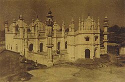
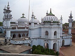
- สถาปัตยกรรมทางประวัติศาสตร์
- มัสยิดจามาแห่งชิตาร์ปูร์ : ตั้งอยู่ใจกลางหมู่บ้านชิตาร์ปูร์ มัสยิดแห่งนี้สร้างขึ้นในปี 1670 และมีสถาปัตยกรรมโมกุล ที่งดงามตระการ ตา
- Chaitarpur shivalaya mandir: ตั้งอยู่บนถนน Shivalaya, Chitarpur
- วัดราชรัปปะ: ตั้งอยู่ห่างจากเมืองชิตาร์ปูร์10 กิโลเมตร (6.2 ไมล์) [ 1 ]
การศึกษา
หมู่บ้านชิตาร์ปูร์มีโรงเรียนและวิทยาลัยเอกชนและของรัฐหลายแห่ง: [ 1 ]
- โรงเรียนมัธยมชิตาร์ปูร์: สร้างขึ้นในปี 1950
- โรงเรียนมัธยมหญิงภาษาอูร์ดูชิตาร์ปูร์ (บันัต): ก่อตั้งขึ้นประมาณปี1980
- โรงเรียน DAV Public School CCL: โรงเรียนสอนภาษาอังกฤษหลักสูตร CBSE แห่งเดียวในพื้นที่
- วิทยาลัยชิตาร์ปูร์อินเตอร์: ก่อตั้งขึ้นในปี 1982
- วิทยาลัยวิศวกรรมศาสตร์ของรัฐบาลรามการ์: เป็นสถาบันเทคนิค แห่งเดียว ในพื้นที่ และเพิ่งเปิดทำการและได้รับการรับรองจาก AICTE ดำเนินการและบริหารจัดการโดยกลุ่มบริษัทเทคโนอินเดีย