
Corwith, Iowa
Corwith, Iowa | |
|---|---|
 Location of Corwith, Iowa | |
| Coordinates: 42°59′20″N93°57′29″W / 42.98889°N 93.95806°W / 42.98889; -93.95806 | |
| Country | USA |
| State | Iowa |
| County | Hancock |
| Area | |
• Total | 1.45 sq mi (3.75 km2) |
| • Land | 1.45 sq mi (3.75 km2) |
| • Water | 0 sq mi (0.00 km2) |
| Elevation | 1,175 ft (358 m) |
| Population (2020) | |
• Total | 266 |
| • Density | 183.7/sq mi (70.91/km2) |
| Time zone | UTC-6 (Central (CST)) |
| • Summer (DST) | UTC-5 (CDT) |
| ZIP code | 50430 |
| Area code | 515 |
| FIPS code | 19-16590 |
| GNIS feature ID | 2393641[2] |
Corwith is a city in Hancock County, Iowa, United States. The population was 266 at the time of the 2020 census.[3]
History
Corwith got its start in the year 1880, following construction of the Minneapolis & St. Louis Railroad through that territory. It burned down in the 1800s.[4] The first buildings to be built were a hotel and the train depot.[5]
Geography
Corwith is located on the Boone River.
According to the United States Census Bureau, the city has a total area of 1.48 square miles (3.83 km2), all land.[6]
Demographics
| Year | Pop. | ±% |
|---|---|---|
| 1890 | 347 | — |
| 1900 | 651 | +87.6% |
| 1910 | 455 | −30.1% |
| 1920 | 635 | +39.6% |
| 1930 | 481 | −24.3% |
| 1940 | 481 | +0.0% |
| 1950 | 480 | −0.2% |
| 1960 | 488 | +1.7% |
| 1970 | 438 | −10.2% |
| 1980 | 480 | +9.6% |
| 1990 | 354 | −26.2% |
| 2000 | 350 | −1.1% |
| 2010 | 309 | −11.7% |
| 2020 | 266 | −13.9% |
| Source:"U.S. Census website". United States Census Bureau. Retrieved March 29, 2020. and Iowa Data CenterSource: | ||
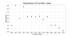
2020 census
จากการสำรวจสำมะโนประชากรปี 2020 [ 8 ]มีประชากร 266 คน 121 ครัวเรือน และ 75 ครอบครัวอาศัยอยู่ในเมืองความหนาแน่นของประชากรอยู่ที่ 183.7 คนต่อตารางไมล์ (70.9/กม. ² ) มีหน่วยที่อยู่อาศัย 147 หน่วย โดยมีความหนาแน่นเฉลี่ย 101.5 หน่วยต่อตารางไมล์ (39.2/กม. ² ) องค์ประกอบทาง เชื้อชาติของเมืองประกอบด้วยคนผิวขาว 88.7% คนผิวดำหรือแอฟริกันอเมริกัน 1.5% ชนพื้นเมือง อเมริกัน 0.8% ชาว เอเชีย 0.0% ชาว หมู่เกาะแปซิฟิก 0.0% จากเชื้อชาติอื่น ๆ 3.4% และจากสองเชื้อชาติขึ้นไป 5.6% บุคคล เชื้อสายฮิสแปนิกหรือลาตินไม่ว่าจะเป็นเชื้อชาติใดก็ตามคิดเป็น 13.5% ของประชากร
จากครัวเรือนทั้งหมด 121 ครัวเรือน พบว่า 24.0% มีเด็กอายุต่ำกว่า 18 ปีอาศัยอยู่ด้วย 47.9% เป็นคู่สมรสที่อาศัยอยู่ด้วยกัน 5.0% เป็นคู่รักที่อยู่กินด้วยกันโดยไม่ได้จดทะเบียนสมรส 24.0% มีหัวหน้าครัวเรือนเป็นหญิงที่ไม่มีคู่สมรสหรือคู่ครอง และ 23.1% มีหัวหน้าครัวเรือนเป็นชายที่ไม่มีคู่สมรสหรือคู่ครอง 38.0% ของครัวเรือนทั้งหมดเป็นครัวเรือนที่ไม่ใช่ครอบครัว 30.6% ของครัวเรือนทั้งหมดประกอบด้วยบุคคลเพียงคนเดียว และ 9.1% มีผู้ที่อาศัยอยู่คนเดียวที่มีอายุ 65 ปีขึ้นไป
อายุเฉลี่ยของประชากรในเมืองอยู่ที่ 47.0 ปี โดย 20.7% ของประชากรมีอายุต่ำกว่า 20 ปี 4.9% มีอายุระหว่าง 20 ถึง 24 ปี 22.2% มีอายุระหว่าง 25 ถึง 44 ปี 32.3% มีอายุระหว่าง 45 ถึง 64 ปี และ 19.9% มีอายุ 65 ปีขึ้นไป สัดส่วนเพศในเมืองคือชาย 50.4% และหญิง 49.6%
สำมะโนประชากรปี 2010
จากการสำรวจสำมะโนประชากร[ 9 ]ในปี 2553 มีประชากร 309 คน 141 ครัวเรือน และ 78 ครอบครัวอาศัยอยู่ในเมืองความหนาแน่นของประชากรอยู่ที่208.8 คนต่อตารางไมล์ (80.6 คนต่อตารางกิโลเมตร) มีหน่วยที่อยู่อาศัย 167 หน่วย โดยมีความหนาแน่นเฉลี่ย112.8 หน่วยต่อตารางไมล์ (43.6 หน่วยต่อตารางกิโลเมตร) องค์ประกอบทางเชื้อชาติของเมืองประกอบด้วยชาวผิวขาว 97.7% ชาวเอเชีย 0.3% เชื้อชาติอื่นๆ 1.3% และเชื้อชาติผสม 0.6% ชาวฮิสแปนิกหรือลาติน ไม่ว่าจะเป็น เชื้อชาติใดก็ตามคิดเป็น 4.2% ของประชากร
มีครัวเรือนทั้งหมด 141 ครัวเรือน โดย 22.0% มีเด็กอายุต่ำกว่า 18 ปีอาศัยอยู่ด้วย 46.1% เป็นคู่สมรสที่อาศัยอยู่ด้วยกัน 7.1% เป็นหัวหน้าครัวเรือนหญิงที่ไม่มีสามี 2.1% เป็นหัวหน้าครัวเรือนชายที่ไม่มีภรรยา และ 44.7% เป็นครัวเรือนที่ไม่ใช่ครอบครัว 35.5% ของครัวเรือนทั้งหมดประกอบด้วยบุคคลเพียงคนเดียว และ 19.9% มีผู้ที่อาศัยอยู่คนเดียวที่มีอายุ 65 ปีขึ้นไป ขนาดครัวเรือนโดยเฉลี่ยอยู่ที่ 2.19 คน และขนาดครอบครัวโดยเฉลี่ยอยู่ที่ 2.85 คน
The median age in the city was 46.3 years. 20.1% of residents were under the age of 18; 6.8% were between the ages of 18 and 24; 20% were from 25 to 44; 31.4% were from 45 to 64; and 21.7% were 65 years of age or older. The gender makeup of the city was 51.8% male and 48.2% female.
2000 census
As of the census[10] of 2000, there were 350 people, 150 households, and 94 families living in the city. The population density was 224.2 inhabitants per square mile (86.6/km2). There were 163 housing units at an average density of 104.4 per square mile (40.3/km2). The racial makeup of the city was 96.57% White, 0.29% Native American, 3.14% from other races. Hispanic or Latino of any race were 6.57% of the population.
There were 150 households, out of which 28.7% had children under the age of 18 living with them, 51.3% were married couples living together, 7.3% had a female householder with no husband present, and 37.3% were non-families. 34.0% of all households were made up of individuals, and 19.3% had someone living alone who was 65 years of age or older. The average household size was 2.33 and the average family size was 2.97.
In the city, the population was spread out, with 25.7% under the age of 18, 5.1% from 18 to 24, 24.6% from 25 to 44, 22.6% from 45 to 64, and 22.0% who were 65 years of age or older. The median age was 40 years. For every 100 females, there were 94.4 males. For every 100 females age 18 and over, there were 88.4 males.
The median income for a household in the city was $27,222, and the median income for a family was $38,333. Males had a median income of $32,031 versus $16,528 for females. The per capita income for the city was $13,054. About 9.8% of families and 11.4% of the population were below the poverty line, including 10.1% of those under age 18 and 8.2% of those age 65 or over.
Education
Algona Community School District is the area school district.[11]
เขตโรงเรียนชุมชนคอร์วิธ-เวสลีย์ให้บริการชุมชนจนกระทั่งยุบเลิกเมื่อวันที่ 1 กรกฎาคม 2558 [ 12 ]เขตดังกล่าวได้ดำเนินการโรงเรียนมัธยมคอร์วิธ-เวสลีย์-ลู เวอร์นการรื้อถอนโรงเรียนคอร์วิธเดิมคาดว่าจะเกิดขึ้นในปี 2559 [ 13 ]ต่อมาเขตโรงเรียนชุมชนลู เวอร์นได้กลายเป็นชุมชน[ 14 ]ตั้งแต่ปี 2558 ลู เวอร์นได้ส่งนักเรียนระดับมัธยมศึกษาไปยังเขตโรงเรียนชุมชนอัลโกนา ซึ่งดำเนินการโรงเรียนมัธยมต้นอัลโกนาและโรงเรียนมัธยมปลายอัลโกนา[ 15 ] ในปี 2566 เขตโรงเรียนชุมชนลู เวอร์นได้ควบรวมเข้ากับเขตโรงเรียนชุมชนอัลโกนา[ 16 ]
บุคคลสำคัญ
- อี. เทอร์แมน แกสคิลล์ผู้ช่วยผู้นำเสียงข้างมากในวุฒิสภาไอโอวา
- ซู มัลลินส์เกษตรกรและสมาชิกสภานิติบัญญัติแห่งรัฐไอโอวา
External links
- Corwith Wesley LuVerne Times