
Donnerskirchen
Donnerskirchen | |
|---|---|
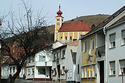 Center of the town with Saint Martin Church | |
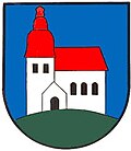 Coat of arms | |
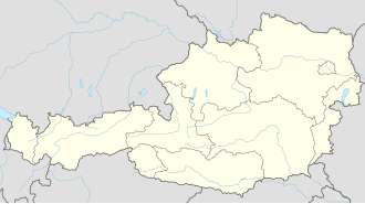  Donnerskirchen Location within Austria | |
| Coordinates: 47°54′N16°38′E / 47.900°N 16.633°E / 47.900; 16.633 | |
| Country | Austria |
| State | Burgenland |
| District | Eisenstadt-Umgebung |
| Government | |
| • Mayor | Johannes Mezgolits (ÖVP) |
| Area | |
• Total | 33.87 km2 (13.08 sq mi) |
| Population (2022-01-01)[2] | |
• Total | 1,846 |
| • Density | 54.50/km2 (141.2/sq mi) |
| Time zone | UTC+1 (CET) |
| • Summer (DST) | UTC+2 (CEST) |
| Postal code | 7082 |
| Area code | 02683 |
Donnerskirchen (Hungarian: Fertőfehéregyháza, Croatian: Bijela Crikva) is a market town in the district Eisenstadt-Umgebung in the Austrian state of Burgenland.
History
Early history and Celtic settlement
Before the birth of Christ, the area formed part of the Celtic kingdom of Noricum and lay within the area of the Celtic hilltop settlement of Burg.
At the foot of the Leitha Mountains, two La Tène-period burials were uncovered during an archaeological excavation carried out by the Burgenland State Museum in the Wolfsbachried area. The two rectangular burial shafts had been cut into calcareoussandstone and lined with wood. One grave contained the remains of a man aged between 50 and 70, the other those of a woman aged between 60 and 80. The graves were aligned on a south–north axis and had already been looted by the time they were discovered. Grave goods found in the man's burial included an iron spearhead, a spear ferrule, a razor, two whetstones, an incomplete iron fibula, a clay bowl, a clay bottle, and several fragments belonging to an iron sword scabbard. In the woman's grave, excavators found four bronze fibulae, a finger ring, a bowl, and two clay bottles.[3]
Roman period
ภายใต้การปกครองของโรมัน บริเวณดอนเนอร์สเคียร์เชนในปัจจุบันตั้งอยู่ในจังหวัดปันโนเนียเส้นทางอำพัน ซึ่งเป็นหนึ่งใน เส้นทางการค้าที่สำคัญที่สุดของ จักรวรรดิโรมันทอดยาวผ่านทางตะวันออกของเทศบาลตามแนวชายฝั่งของทะเลสาบนอยซีดล์ที่มีต้นกกขึ้นหนาแน่น
ประวัติศาสตร์การเมืองยุคต้นสมัยใหม่และยุคสมัยใหม่
ในปี ค.ศ. 1659 จักรพรรดิเลโอโปลด์ที่ 1ได้พระราชทานสิทธิ์การจัดตลาด ให้แก่เมืองดอนเนอร์สเคียร์ เชน
เช่นเดียวกับส่วนอื่นๆ ของแคว้นเบอร์เกนลันด์ เมืองนี้เคยเป็นส่วนหนึ่งของฮังการีจนถึงปี 1920/21 ตั้งแต่ปี 1898 เป็นต้นมา เนื่องด้วย นโยบาย การทำให้เป็นฮังการีของรัฐบาลในบูดาเปสต์เมืองนี้จึงใช้ชื่อภาษาฮังการีว่า Sopronfehéregyháza หลังจากสงครามโลกครั้งที่หนึ่งหลังจากการเจรจาที่ยืดเยื้อ ฮังการีตะวันตกของเยอรมันก็ตกเป็นของออสเตรียภายใต้สนธิสัญญาแซงต์-แฌร์ แมง และทรีอานอนในปี 1919 ตั้งแต่ปี 1921 เป็นต้นมา เมืองนี้เป็นส่วนหนึ่งของรัฐสหพันธ์เบอร์เกนลันด์ที่จัดตั้งขึ้นใหม่
สงครามโลกครั้งที่สอง
ในช่วงสงครามโลกครั้งที่สองดอนเนอร์สเคียร์เชนเป็นส่วนหนึ่งของเขตก่อสร้างส่วนกลาง (ไอเซนชตัดท์) ของกำแพงตะวันออกเฉียงใต้ ที่วางแผนไว้ ค่ายกักกันขนาดเล็กตั้งอยู่ใกล้หมู่บ้าน ในปี 1951 นิโคลาอุส ชอร์นถูกตัดสินว่ามีความผิดในข้อหาฆาตกรรมแรงงานทาสชาวยิวในค่ายดอนเนอร์สเคียร์เชนในเดือนมกราคม พ.ศ. 2488 และถูกตัดสินจำคุกตลอดชีวิต ชอร์นเป็นหัวหน้าค่าย เหยื่อส่วนใหญ่ของเขาเป็นชาวยิวฮังการี[ 4 ] [ 5 ]
ประชากร
| ปี | โผล่. | ±% |
|---|---|---|
| 1869 | 1,649 | — |
| 1880 | 1,576 | −4.4% |
| 1890 | 1,799 | +14.1% |
| ปี ค.ศ. 1900 | 1,783 | -0.9% |
| 1910 | 1,741 | −2.4% |
| 1923 | 1,824 | +4.8% |
| 1934 | 1,842 | +1.0% |
| 1939 | 1,856 | +0.8% |
| 1951 | 1,622 | −12.6% |
| 1961 | 1,646 | +1.5% |
| 1971 | 1,593 | −3.2% |
| 1981 | 1,576 | -1.1% |
| 1991 | 1,556 | −1.3% |
| 2001 | 1,649 | +6.0% |
| 2011 | 1,729 | +4.9% |
| 2011 | 1,719 | -0.6% |
| 2021 | 1,840 | +7.0% |
ขนส่ง
ทางรถไฟแพนโนเนียมีสถานีอยู่ในชุมชนแห่งนี้
ดูเพิ่มเติม
External links
- Nona.net— region maps of Donnerskirchen
- www.WineDirectories.comArchived 2006-03-20 at the Wayback Machine— Wineries in Donnerskirchen
- www.WebTourist.net— Tourism information
