
ฟาร์มิงตัน รัฐเดลาแวร์
ฟาร์มิงตัน รัฐเดลาแวร์ | |
|---|---|
 ผนึก | |
 ที่ตั้งของเมืองฟาร์มิงตันในเคาน์ตีเคนต์ รัฐเดลาแวร์ | |
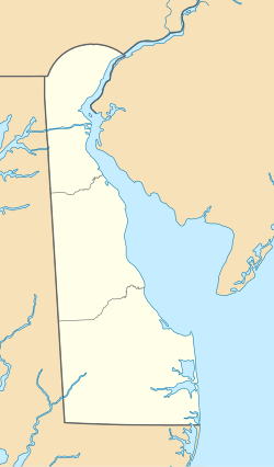  ฟาร์มิงตัน ตั้งอยู่ในรัฐเดลาแวร์  ฟาร์มิงตัน ฟาร์มิงตัน (สหรัฐอเมริกา) | |
| พิกัด: 38°52′09″เหนือ75°34′43″ตะวันตก / 38.86917°N 75.57861°W | |
| ประเทศ |  สหรัฐอเมริกา สหรัฐอเมริกา |
| สถานะ |  เดลาแวร์ เดลาแวร์ |
| เขต | เคนท์ |
| รัฐบาล | |
| • นายกเทศมนตรี | ซินดี้ โบลิน[ 1 ] |
| พื้นที่ | |
• ทั้งหมด | 0.073 ตารางไมล์ (0.19 ตารางกิโลเมตร ) |
| • ที่ดิน | 0.073 ตารางไมล์ (0.19 ตารางกิโลเมตร ) |
| • น้ำ | 0 ตารางไมล์ (0.00 ตารางกิโลเมตร ) |
| ระดับความสูง | 62 ฟุต (19 เมตร) |
| ประชากร ( 2020 ) | |
• ทั้งหมด | 92 |
| • ความหนาแน่น | 1,265.2/ตร.ไมล์ (488.48/ ตร.กม. ) |
| เขตเวลา | UTC−5 ( ตะวันออก (EST) ) |
| • ฤดูร้อน ( เวลาออมแสง ) | 4 โมงเช้า (EDT) |
| รหัสไปรษณีย์ | 19950 |
| รหัสพื้นที่ | 302 |
| รหัส FIPS | 10-25840 |
| รหัสคุณลักษณะGNIS | 213949 [ 3 ] |
| เว็บไซต์ | www.farmingtondelaware.com |
ฟาร์มิงตันเป็นเมืองในเคาน์ตีเคนต์ รัฐเดลาแวร์สหรัฐอเมริกา เป็นส่วนหนึ่งของเขตมหานครโดเวอร์มีประชากร 92 คนในปี 2020 [ 4 ]
ประวัติศาสตร์
เดิมทีเมืองฟาร์มิงตันก่อตั้งขึ้นในชื่อแฟลตไอรออนในปี 1855 เมื่อทางรถไฟสร้างสถานีที่ทางแยก ณ สถานที่แห่งนี้ มีการจัดตั้ง ที่ทำการไปรษณีย์ขึ้นในปี 1858 เมืองนี้เป็นที่ตั้งของโรงเรียนฟาร์มิงตันอะคาเดมีตั้งแต่ปี 1868 ถึง 1878 ในช่วงทศวรรษ 1880 ฟาร์มิงตันมีประชากร 300 คน และเป็นที่ตั้งของโรงงานบรรจุกระป๋องและโรงงานระเหยผลไม้[ 5 ]บ้านธาร์ปได้รับการขึ้นทะเบียนในทะเบียนสถานที่ทางประวัติศาสตร์แห่งชาติในปี 1973 [ 6 ]ฟาร์มิงตันเคยมีที่ทำการไปรษณีย์ที่มีรหัสไปรษณีย์ 19942 อย่างไรก็ตาม ที่ทำการไปรษณีย์ปิดตัวลงและรหัสไปรษณีย์ดังกล่าวถูกยกเลิกเมื่อวันที่ 13 มกราคม 1996 [ 7 ]ปัจจุบันฟาร์มิงตันได้รับการบริการโดย ที่ทำการไปรษณีย์ กรีนวูดซึ่งมีรหัสไปรษณีย์ 19950
ภูมิศาสตร์
ตามข้อมูลจากสำนักงานสำมะโนประชากรแห่งสหรัฐอเมริกาเมืองนี้มีพื้นที่ทั้งหมด 0.1 ตารางไมล์ (0.26 ตารางกิโลเมตร)ซึ่งเป็นพื้นที่ดินทั้งหมด
ข้อมูลประชากร
| สำมะโนประชากร | โผล่. | บันทึก | %± |
|---|---|---|---|
| 1890 | 468 | — | |
| 1910 | 255 | — | |
| 1920 | 124 | −51.4% | |
| 1930 | 117 | −5.6% | |
| 1940 | 120 | 2.6% | |
| 1950 | 113 | −5.8% | |
| 1960 | 142 | 25.7% | |
| 1970 | 109 | −23.2% | |
| 1980 | 141 | 29.4% | |
| 1990 | 122 | −13.5% | |
| 2000 | 75 | −38.5% | |
| 2010 | 110 | 46.7% | |
| 2020 | 92 | −16.4% | |
| สำมะโนประชากรทุกสิบปีของสหรัฐอเมริกา[ 8 ] | |||
At the 2000 census there were 75 people, 31 households, and 20 families living in the town. The population density was 1,075.6 inhabitants per square mile (415.3/km2). There were 35 housing units at an average density of 501.9 units per square mile (193.8 units/km2). The racial makeup of the town was 99.00% White.[9] Of the 31 households 22.6% had children under the age of 18 living with them, 48.4% were married couples living together, 6.5% had a female householder with no husband present, and 32.3% were non-families. 25.8% of households were one person and 16.1% were one person aged 65 or older. The average household size was 2.42 and the average family size was 2.76.
The age distribution was 20.0% under the age of 18, 4.0% from 18 to 24, 32.0% from 25 to 44, 25.3% from 45 to 64, and 18.7% 65 or older. The median age was 42 years. For every 100 females, there were 120.6 males. For every 100 females age 18 and over, there were 130.8 males.
The median household income was $41,458 and the median family income was $38,750. Males had a median income of $17,917 versus $21,429 for females. The per capita income for the town was $16,423. There were no families and 7.0% of the population living below the poverty line, including no under eighteens and none of those over 64.
Infrastructure
Transportation

No state highways pass directly through Farmington. U.S. Route 13 passes north–south just beyond the eastern edge of Farmington on Dupont Highway and leads north toward Harrington and south toward Greenwood. Main Street begins at US 13 and runs east–west through Farmington, becoming Andrewville Road outside the town and leading west toward Andrewville.[10] The Delmarva Central Railroad's Delmarva Subdivision line passes north–south through Farmington.[11]
Utilities
Delmarva Power, a subsidiary of Exelon, provides electricity to Farmington.[12]Chesapeake Utilities provides natural gas to the town.[13]
Education
Farmington is in the Woodbridge School District.[14]Woodbridge High School is the zoned high school.
Notable people
- Lyman Pierson Powell (born 1866), (alternate spelling is Pearson), Episcopalian priest, Hobart college president, historian and author
- William Tharp, 36th Governor of Delaware
ลิงก์ภายนอก
 สื่อที่เกี่ยวข้องกับเมืองฟาร์มิงตัน รัฐเดลาแวร์ในวิกิมีเดียคอมมอนส์
- เว็บไซต์อย่างเป็นทางการ