
เฟรเซอร์กันจ์
เฟรเซอร์กันจ์ | |
|---|---|
หมู่บ้าน | |
  เฟรเซอร์กันจ์ ตั้งอยู่ในรัฐเวสต์เบงกอล แสดงแผนที่ของรัฐเวสต์เบงกอล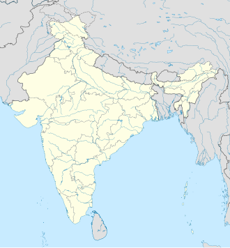 เฟรเซอร์กันจ์ ที่ตั้งในประเทศอินเดีย แสดงแผนที่ประเทศอินเดีย | |
| พิกัด: 21°35′06″N 88°15′31″E / 21.5851°N 88.2585°E / 21.5851; 88.2585 | |
| ประเทศ |  อินเดีย อินเดีย |
| สถานะ |  รัฐเวสต์เบงกอล รัฐเวสต์เบงกอล |
| เขต | เซาท์ 24 ปาร์กานาส |
| บล็อกซีดี | นัมคานา |
| ระดับความสูง | 4 เมตร (13 ฟุต) |
| ภาษา | |
| • เป็นทางการ | เบงกาลี[ 1 ] [ 2 ] |
| • เจ้าหน้าที่ เพิ่มเติม | ภาษาอังกฤษ[ 1 ] |
| เขตเวลา | 5:30 น. ( เวลาอินเดีย ) (UTC+1 ) |
| เข็มหมุด | 743357 |
| รหัสโทรศัพท์ | +91 3210 |
| การลงทะเบียนยานพาหนะ | WB -19 ถึงWB -22, WB -95 ถึงWB -99 |
| เขตเลือกตั้งโลคสภา | มธุราปุระ (SC) |
| เขตเลือกตั้งสภาวิธานสภา | ซาการ์ |
| เว็บไซต์ | www.s24pgs.gov.in |
เฟรเซอร์กันจ์เป็นหมู่บ้านและองค์การบริหารส่วนตำบลที่อยู่ในเขตอำนาจของสถานีตำรวจนามคานา ใน เขต การปกครอง ย่อยนามคา นา ในอำเภอกักด วิป จังหวัดเซาท์ 24 ปาร์กานาสรัฐเวสต์เบงกอลประเทศอินเดีย
ประวัติศาสตร์
เซอร์แอนดรูว์ เฟรเซอร์รองผู้ว่าการเบงกอล (ค.ศ. 1903–1908) ในช่วงต้นศตวรรษที่ 20 ได้รับการยกย่องว่าเป็นผู้ "ค้นพบ" สถานที่แห่งนี้ เพื่อเป็นการยกย่องความพยายามของเขา จึงได้ตั้งชื่อว่าเฟรเซอร์กันจ์ มีบ้านทรุดโทรมหลังหนึ่งอยู่ใกล้ชายหาด ซึ่งชาวบ้านบอกว่าเป็นบ้านที่เฟรเซอร์เคยพักอาศัย[ 3 ]
ภูมิศาสตร์


[[Kakdwip]] (R)
\", \"description\": \" ([https://geohack.toolforge.org/geohack.php?params=21.87583;88.18528_dim:2000 21.87583,88.18528])\", \"marker-symbol\": \"-number-F10995\", \"marker-size\": \"medium\", \"marker-color\": \"#c42222\" }, \"geometry\": {\"type\": \"Point\", \"coordinates\": [88.18528,21.87583] } }, { \"type\": \"Feature\", \"properties\": { \"title\": \"R
[[Harwood Point]] (R)
\", \"description\": \" ([https://geohack.toolforge.org/geohack.php?params=21.87972;88.16611_dim:2000 21.87972,88.16611])\", \"marker-symbol\": \"-number-F10995\", \"marker-size\": \"medium\", \"marker-color\": \"#0048ba\" }, \"geometry\": {\"type\": \"Point\", \"coordinates\": [88.16611,21.87972] } }, { \"type\": \"Feature\", \"properties\": { \"title\": \"R
[[Namkhana]] (R)
\", \"description\": \" ([https://geohack.toolforge.org/geohack.php?params=21.76972;88.23139_dim:2000 21.76972,88.23139])\", \"marker-symbol\": \"-number-F10995\", \"marker-size\": \"medium\", \"marker-color\": \"#c42222\" }, \"geometry\": {\"type\": \"Point\", \"coordinates\": [88.23139,21.76972] } }, { \"type\": \"Feature\", \"properties\": { \"title\": \"R
Fraserganj (R)
\", \"description\": \" ([https://geohack.toolforge.org/geohack.php?params=21.585;88.25833_dim:2000 21.585,88.25833])\", \"marker-symbol\": \"-number-F10995\", \"marker-size\": \"medium\", \"marker-color\": \"#000000\" }, \"geometry\": {\"type\": \"Point\", \"coordinates\": [88.25833,21.585] } }, { \"type\": \"Feature\", \"properties\": { \"title\": \"R
[[Rudranagar]] (R)
\", \"description\": \" ([https://geohack.toolforge.org/geohack.php?params=21.74556;88.09417_dim:2000 21.74556,88.09417])\", \"marker-symbol\": \"-number-F10995\", \"marker-size\": \"medium\", \"marker-color\": \"#c42222\" }, \"geometry\": {\"type\": \"Point\", \"coordinates\": [88.09417,21.74556] } }, { \"type\": \"Feature\", \"properties\": { \"title\": \"R
[[Gangasagar]] (R)
\", \"description\": \" ([https://geohack.toolforge.org/geohack.php?params=21.64722;88.07528_dim:2000 21.64722,88.07528])\", \"marker-symbol\": \"-number-F10995\", \"marker-size\": \"medium\", \"marker-color\": \"#0048ba\" }, \"geometry\": {\"type\": \"Point\", \"coordinates\": [88.07528,21.64722] } }, { \"type\": \"Feature\", \"properties\": { \"title\": \"R
[[Patharpratima]] (R)
\", \"description\": \" ([https://geohack.toolforge.org/geohack.php?params=21.79667;88.35528_dim:2000 21.79667,88.35528])\", \"marker-symbol\": \"-number-F10995\", \"marker-size\": \"medium\", \"marker-color\": \"#c42222\" }, \"geometry\": {\"type\": \"Point\", \"coordinates\": [88.35528,21.79667] } }, { \"type\": \"Feature\", \"properties\": { \"title\": \"R
[[Gobardhanpur]] (R)
\", \"description\": \" ([https://geohack.toolforge.org/geohack.php?params=21.64806;88.40444_dim:2000 21.64806,88.40444])\", \"marker-symbol\": \"-number-F10995\", \"marker-size\": \"medium\", \"marker-color\": \"#0048ba\" }, \"geometry\": {\"type\": \"Point\", \"coordinates\": [88.40444,21.64806] } }, { \"type\": \"Feature\", \"properties\": { \"title\": \"R
[[Ganespur]] (R)
\", \"description\": \" ([https://geohack.toolforge.org/geohack.php?params=21.89167;88.21111_dim:2000 21.89167,88.21111])\", \"marker-symbol\": \"-number-F10995\", \"marker-size\": \"medium\", \"marker-color\": \"#c42222\" }, \"geometry\": {\"type\": \"Point\", \"coordinates\": [88.21111,21.89167] } }, { \"type\": \"Feature\", \"properties\": { \"title\": \"R
[[Ramganga, South 24 Parganas]] (R)
\", \"description\": \" ([https://geohack.toolforge.org/geohack.php?params=21.80389;88.37361_dim:2000 21.80389,88.37361])\", \"marker-symbol\": \"-number-F10995\", \"marker-size\": \"medium\", \"marker-color\": \"#c42222\" }, \"geometry\": {\"type\": \"Point\", \"coordinates\": [88.37361,21.80389] } }, { \"type\": \"Feature\", \"properties\": { \"title\": \"R
[[Harinbari]] (R)
\", \"description\": \" ([https://geohack.toolforge.org/geohack.php?params=21.75694;88.09806_dim:2000 21.75694,88.09806])\", \"marker-symbol\": \"-number-F10995\", \"marker-size\": \"medium\", \"marker-color\": \"#c42222\" }, \"geometry\": {\"type\": \"Point\", \"coordinates\": [88.09806,21.75694] } }, { \"type\": \"Feature\", \"properties\": { \"title\": \"R
[[Bakkhali]] (R)
\", \"description\": \" ([https://geohack.toolforge.org/geohack.php?params=21.56306;88.25944_dim:2000 21.56306,88.25944])\", \"marker-symbol\": \"-number-F10995\", \"marker-size\": \"medium\", \"marker-color\": \"#0048ba\" }, \"geometry\": {\"type\": \"Point\", \"coordinates\": [88.25944,21.56306] } } ] } ]"}}">
ภาพรวมของพื้นที่
เขตย่อย Kakdwip มีประชากรในชนบททั้งหมด อำเภอทั้งหมดตั้งอยู่ในสามเหลี่ยมปากแม่น้ำคงคาทางตอนใต้ของสามเหลี่ยมปากแม่น้ำมีคลองและเกาะมากมาย เช่นเกาะเฮนรีเกาะสาครเกาะเฟรเดอริก และเกาะเฟรเซอร์กันจ์ เขตย่อยนี้เป็นส่วนหนึ่งของการตั้งถิ่นฐานซุนดาร์บันส์การพัฒนาที่เกิดขึ้นทั่วประเทศเมื่อไม่นานมานี้คือการรักษาความปลอดภัยพื้นที่ชายฝั่งโดยกองกำลังชายฝั่งพิเศษ พื้นที่นี้ดึงดูดนักท่องเที่ยวจำนวนมาก โดยเฉพาะกังกาสาครและเฟรเซอร์กันจ์-บักคาลี โกบาร์ดันปุระมีอนาคตที่สดใส[ 4 ] [ 5 ] [ 6 ]
หมายเหตุ: แผนที่ด้านข้างแสดงสถานที่สำคัญบางแห่งในหมู่บ้านจัดสรร สถานที่ทั้งหมดที่ทำเครื่องหมายไว้ในแผนที่นี้เชื่อมโยงไปยังแผนที่ขนาดใหญ่แบบเต็มหน้าจอ
ที่ตั้ง
Fraserganj ตั้งอยู่ที่พิกัด21°35′06″N 88°15′31″E / 21.5851°N 88.2585°E / 21.5851; 88.2585
การบริหารราชการส่วนท้องถิ่น
สถานีตำรวจ
สถานีตำรวจชายฝั่ง Frezerganj ครอบคลุมพื้นที่ 34.07 ตาราง กิโลเมตรมีเขตอำนาจเหนือบางส่วนของเขตปกครอง Namkhana CD สถานีตำรวจชายฝั่งจัดตั้งขึ้นโดยมีวัตถุประสงค์เพื่อการรักษาความปลอดภัยในพื้นที่ห่างไกลของ Sundarbans อย่างมีประสิทธิภาพ ตำรวจมีการลาดตระเวนทางน้ำเป็นประจำ[ 7 ] [ 8 ]
สิ่งอำนวยความสะดวก
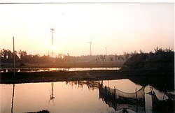
Fraserganj มีท่าเรือประมงที่ดำเนินการโดยรัฐบาลและฟาร์มพลังงานลมที่ผลิตกระแสไฟฟ้า[ 9 ]
คลื่นที่ค่อยๆ กลิ้งไปมาเล่นบน ชายหาดยาว 8 กิโลเมตรจากบักคาลีถึงเฟรเซอร์กันจ์ ซึ่งเป็นสถานที่คู่แฝดที่ปัจจุบันกลายเป็นพื้นที่ต่อเนื่องกัน[ 10 ]
ขนส่ง
เฟรเซอร์กันจ์ตั้งอยู่บน ทางหลวงแห่งชาติ หมายเลข12 [ 11 ]
สถานีรถไฟน้ำขานาตั้งอยู่ใกล้เคียง[ 11 ]
การดูแลสุขภาพ
มีศูนย์สุขภาพปฐมภูมิอยู่ที่ฟราเซอร์กันจ์ ซึ่งมีเตียง 10 เตียง[ 12 ]