อ่าน 1 นาที
Grasleben
Grasleben is a municipality in the district of Helmstedt , in Lower Saxony , Germany . It is situated approximately 10 km north of Helmstedt , and 20 km southeast of Wolfsburg .
Grasleben
Coordinates: 52°19′N11°1′E / 52.317°เหนือ 11.017°ตะวันออก
Grasleben | |
|---|---|
 Coat of arms | |
Location of Grasleben within Helmstedt district  | |
 Location of Grasleben | |
 Grasleben  Grasleben | |
| Coordinates: 52°19′N11°1′E / 52.317°เหนือ 11.017°ตะวันออก | |
| Country | Germany |
| State | Lower Saxony |
| District | Helmstedt |
| Municipal assoc. | Grasleben |
| Government | |
| • Mayor | Veronika Koch (CDU) |
| Area | |
• Total | 11.27 km2 (4.35 sq mi) |
| Elevation | 99 m (325 ft) |
| Population (2024-12-31)[1] | |
• Total | 2,316 |
| • Density | 205.5/km2 (532.2/sq mi) |
| Time zone | UTC+01:00 (CET) |
| • Summer (DST) | UTC+02:00 (CEST) |
| Postal codes | 38368 |
| Dialling codes | 05357 |
| Vehicle registration | HE |
| Website | www.samtgemeinde-grasleben.de |
Grasleben is a municipality in the district of Helmstedt, in Lower Saxony, Germany. It is situated approximately 10 km north of Helmstedt, and 20 km southeast of Wolfsburg. The Municipality Grasleben includes the villages of Grasleben and Heidwinkel.
Grasleben is also the seat of the Samtgemeinde ("collective municipality") Grasleben.
 Inner German border at Grasleben, 1989
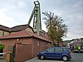 Salt mining
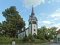 The Lutheran church
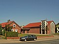 The catholic church


สรุปเนื้อหา
ข้อมูลสำคัญจากบทความ
ข้อมูลสำคัญเกี่ยวกับ Grasleben
Grasleben is a municipality in the district of Helmstedt , in Lower Saxony , Germany . It is situated approximately 10 km north of Helmstedt , and 20 km southeast of Wolfsburg .