
Random Hills
The Random Hills (74°7′S164°25′E / 74.117°S 164.417°E / -74.117; 164.417 (Random Hills)) are a group of rugged hills in Victoria Land, Antarctica. They are bounded on the west by Campbell Glacier and on the east by Tinker Glacier and Wood Bay. They are centered about 15 nautical miles (28 km; 17 mi)) north-northwest of Mount Melbourne.[1]
Exploration and name
The Random Hills were named by the Southern Party of the New Zealand Geological Survey Antarctic Expedition (NZGSAE), 1966–67, because of the random orientation of the ridges which comprise the feature.[1]
Geology
The Random Hills are part of the Melbourne Volcanic Province of the McMurdo Volcanic Group. K–Ar or Rb–Sr dating has given ages of 12.63 ± 0.17 million years and 12.43 ± 0.16 million years for Random Hills hawaiite.[2]
Location
The Random Hills lie between the Tinker Glacier Tongue to the east, Baker Rocks on the Mount Melbourne peninsula to the south, and Bier Point and the Campbell Glacier to the west. The Burns Glacier separates the hills from Pinckard Table to the east. The Clausnitzer Glacier flows eastward through the hills to join the Tinker Glacier.[3]
Features
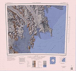
Features and nearby features include:
Harrow Peaks
74°04′S164°45′E / 74.067°S 164.750°E / -74.067; 164.750. A group of rugged peaks in the east part of Random Hills, bounded on the north by Clausnitzer Glacier and on the east by Tinker Glacier, overlooking the northwest extremity of Wood Bay. Mapped by the United States Geological Survey (USGS) from surveys and United States Navy air photos, 1955-63. Named by United States Advisory Committee on Antarctic Names (US-ACAN) for Geoffrey N. Harrow, biologist at McMurdo Station, 1965-66 season.[4]
Mount McGee
74°03′S 164°33′E / 74.050°S 164.550°E / -74.050; 164.550ภูเขา1,410 เมตร (4,630ฟุต)ตั้งอยู่บนสันเขาทางด้านเหนือของธารน้ำแข็ง Clausnitzer ใน Random Hills ทำแผนที่โดย USGS จากการสำรวจและภาพถ่ายทางอากาศของกองทัพเรือสหรัฐฯ ระหว่างปี 1955-1963 ตั้งชื่อโดย US-ACAN ตามชื่อของ Lawrence E. McGee นักธรณีวิทยาที่สถานี McMurdoในฤดูกาล 1965-1966[5]
เบเกอร์ ร็อคส์
74°14′S 164°45′E / 74.233°S 164.750°E / -74.233; 164.750 . แนวหินที่ยื่นออกมาคล้ายสันเขา ตั้งอยู่ทางทิศตะวันตกของอ่าววูด2 ไมล์ทะเล (3.7กม.; 2.3ไมล์)และทางทิศเหนือของภูเขาเมลเบิร์น7 ไมล์ทะเล (13กม.; 8.1ไมล์)ทำแผนที่โดย USGS จากการสำรวจและภาพถ่ายทางอากาศของกองทัพเรือสหรัฐฯ ระหว่างปี 1955-1963 ตั้งชื่อโดย US-ACAN ตามชื่อของ Billy-Ace Baker เจ้าหน้าที่วิทยุสื่อสาร คณะสำรวจฤดูหนาวของสถานี McMurdo ในปี 1963, 1967, 1971 และ 1975 และฤดูร้อน ปี 1976-1980[6]
เบียร์พอยต์
74°10′S 164°09′E / 74.167°S 164.150°E / -74.167; 164.150จุดที่ยื่นออกมาทางด้านตะวันออกของธารน้ำแข็งแคมป์เบลห่างจากภูเขาควีนส์แลนด์7 ไมล์ทะเล (13กม.; 8.1ไมล์)ทำแผนที่โดย USGS จากการสำรวจและภาพถ่ายทางอากาศของกองทัพเรือสหรัฐฯ ระหว่างปี 1955-1963 ตั้งชื่อโดย US-ACAN ตามชื่อของ Jeffrey W. Bier นักชีววิทยา คณะสำรวจฤดูหนาวของสถานี McMurdo ในปี 1966[7]
โต๊ะพินคาร์ด
74°00′S 164°03′E / 74.000°S 164.050°E / -74.000; 164.050ที่ราบสูงปกคลุมด้วยน้ำแข็งยาว8 ไมล์ทะเล (15กม.; 9.2ไมล์)3 ไมล์ทะเล (5.6กม.; 3.5ไมล์)ตั้งอยู่ระหว่างธารน้ำแข็งสติกซ์และธารน้ำแข็งเบิร์นส์ทำแผนที่โดย USGS จากการสำรวจและภาพถ่ายทางอากาศของกองทัพเรือสหรัฐฯ ระหว่างปี 1955-1963 ตั้งชื่อโดย US-ACAN ตามชื่อของวิลเลียม พิงค์การ์ด นักชีววิทยาประจำสถานีแมคมูร์โด ในฤดูกาล 1965-1966[8]
Sources
- Alberts, Fred G., ed. (1995), Geographic Names of the Antarctic(PDF) (2 ed.), United States Board on Geographic Names, retrieved 2024-01-30
 This article incorporates public domain material from websites or documents of the United States Board on Geographic Names.
 - Mount Melbourne, USGS: United States Geographic Board, retrieved 2024-03-03
{{citation}}: CS1 maint: publisher location (link)

This article incorporates public domain material from websites or documents of the United States Geological Survey.