อ่าน 6 นาที
Inn (river)
The Inn (German pronunciation:ⓘ; Latin: Aenus;Romansh: En) is a river in Switzerland, Austria and Germany.
Inn (river)
| Inn Romansh: En | |
|---|---|
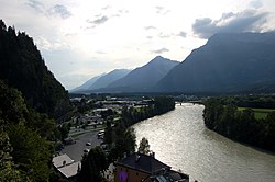 Lower Inn valley from Rattenberg castle | |
 | |
| Location | |
| Countries | |
| Cities | |
| Physical characteristics | |
| Source | |
| • location | Swiss Alps (Lägh dal Lunghin) |
| • coordinates | 46°25′00″เหนือ9°40′35″ตะวันออก / 46.41673°N 9.67645°E |
| • elevation | 2,484 m (8,150 ft) |
| Mouth | |
• location | Danube (Passau) |
• coordinates | 48°34′25″เหนือ13°28′38″ตะวันออก / 48.57353°N 13.47713°E |
• elevation | 291 m (955 ft) |
| Length | 518.5 km (322.2 mi)[1] |
Basin size | 26,053 km2 (10,059 sq mi)[1] |
| Discharge | |
| • location | mouth |
| • average | 735 m3/s (26,000 cu ft/s) |
| Basin features | |
| Progression | Danube→ Black Sea |

The Inn (German pronunciation:[ɪn]ⓘ; Latin: Aenus;[2]Romansh: En) is a river in Switzerland, Austria and Germany. The 518 km (322 mi) long river is a right tributary of the Danube, being the third largest tributary of the Danube by discharge. The highest point of its drainage basin is the summit of Piz Bernina at 4,049 m (13,284 ft). The Engadine, the valley of the En, is the only Swiss valley whose waters end up in the Black Sea (via the Danube).
Etymology
The name Inn is derived from the old Celtic words en and enios, meaning water. In a document of 1338, the river was named Wasser (German for water). The first written mention from the years 105 to 109 (Publii Corneli Taciti historiarium liber tertius) reads: "... Sextilius Felix... ad occupandam ripam Aeni fluminis, quod Raetos Noricosque interfluit, missus..." ("... Sextilius Felix was sent to capture the banks of the Inn, which flows between the Rhaetian people and the Noric people.")[3] The river is also mentioned by other authors of the Roman Empire as Ainos (Greek) or Aenus (Latin). In medieval Latin it was written as Enus or Oenus. The change in the old Bavarian language from e to i turned Enus to In. Until the 17th century, it was written In or Yn, but also Ihn or Yhn. The double-n appeared only in the 16th century, for example in the Tyrolian Landreim of 1557, and since the 18th century this spelling and pronunciation with a short vowel has been customary.[4]
The mentions in Roman times refer to the lower course. The Tyrolean section was first called Aenus by Venantius Fortunatus in the 6th century. The name Engadin and the Romansh name En indicate that the upper reaches of the river have long been called this way. Even though it was occasionally believed that the Inn originated near the Adige at the Reschen Pass, since the 16th century at the latest the origin has been seen uniformly in the area of the lakes at the Maloja Pass.[4]
A connection may exist between the name Inn and the name of the French river Ain.[5]
Geography
ต้นกำเนิดของแม่น้ำอินน์ตั้งอยู่ในเทือกเขาแอลป์ของส วิตเซอร์แลนด์ ทางตะวันตกของ เมือง เซนต์มอริตซ์ใน ภูมิภาค เอนกาดีนซึ่งตั้งชื่อตามแม่น้ำ ( ภาษาโรมันช์ Engiadina ; ภาษาละตินvallis Eniatina ) หลังจากไหลออกจากต้นกำเนิดไม่นาน แม่น้ำอินน์ก็ไหลผ่านทะเลสาบที่ใหญ่ที่สุดในเส้นทาง ได้แก่ทะเลสาบซิลส์และทะเลสาบซิลวาปลา ณา จากนั้นไหลไปทางทิศตะวันออกเฉียงเหนือ เข้าสู่ประเทศออสเตรีย และจากเมืองแลนเด็คไปทางตะวันออกผ่านรัฐไทโรล ของออสเตรีย และเมืองหลวงอินส์บรุค ( สะพานข้ามแม่น้ำอินน์ ) และข้ามพรมแดนเข้าสู่รัฐบาวาเรียใกล้กับเมืองคูฟสไตน์
ในดินแดนบาวาเรีย แม่น้ำสายนี้ไหลไปทางเหนือ ผ่านเมืองโรเซนไฮ ม์ วาสเซอร์บูร์ก อัม อินน์และวาลด์ไครบูร์ก จากนั้น ก็เลี้ยวไปทางตะวันออก ไหลผ่านเมืองมูห์ลดอร์ฟและนอยททิงและมีแม่น้ำสาขาหลักสองสายคือแม่น้ำอัลซ์และแม่น้ำซาลซัค ไหล มารวมกันจนมีปริมาณน้ำมากขึ้น จากจุดนี้ไปจนถึง แม่น้ำดานู บ แม่น้ำสายนี้ เป็นพรมแดนระหว่างเยอรมนี (บาวาเรีย) และออสเตรีย ( อัปเปอร์ออสเตรีย ) เมืองต่างๆ ที่ตั้งอยู่ริมแม่น้ำช่วงสุดท้ายนี้ ได้แก่มาร์กท์ล อัม อินน์ซิมบัค ออน อินน์บราวน์เนา อัม อินน์และชาร์ดิง
ที่เมืองพัสเซาแม่น้ำอินน์ไหลลงสู่แม่น้ำดานูบในที่สุด (เช่นเดียวกับแม่น้ำอิลซ์ที่นั่น) แม้ว่าแม่น้ำอินน์จะมีปริมาณน้ำไหลเฉลี่ยมากกว่าแม่น้ำดานูบเมื่อมาบรรจบกันที่พัสเซา และลุ่มน้ำของแม่น้ำอินน์มีภูเขาปิซ แบร์นินา ซึ่งเป็นจุดที่สูงที่สุดในลุ่มน้ำดานูบ แต่แม่น้ำอินน์ก็ถือเป็นสาขาของแม่น้ำดานูบ ซึ่งมีความยาวมากกว่า มีพื้นที่ระบายน้ำมากกว่า และมีปริมาณน้ำไหลสม่ำเสมอกว่า แม่น้ำอินน์เป็นแม่น้ำเพียงสายเดียวที่กำเนิดในสวิตเซอร์แลนด์และไหลลงสู่ทะเลดำ (ผ่านทางแม่น้ำดานูบ)
ลำน้ำสาขา

- Right tributaries (in downstream order): Flaz, Spöl, Clemgia, Faggenbach, Pitzbach, Ötztaler Ache, Melach, Sill, Ziller, Alpbach, Wildschönauer Ache, Brixentaler Ache, Weißache, Kaiserbach, Rohrdorfer Ache, Sims, Murn, Alz, Salzach, Enknach, Mattig, Ach, Hartbach, Antiesen, Pram
- Left tributaries (in downstream order; two different rivers called Rott exist): Beverin, Schergenbach, Sanna, Gurglbach, Höttinger Bach, Mühlauer Bach, Brandenberger Ache, Kieferbach, Auerbach, Kirchbach, Mangfall, Rott, Attel, Isen, Rott
Flow
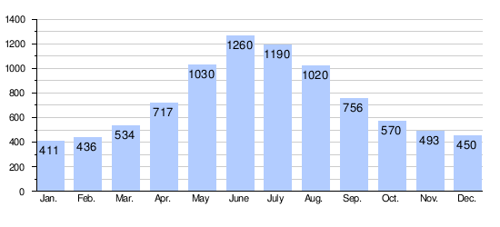
The average discharge at the mouth of the Inn is 735 m3/s (26,000 cu ft/s).[6]
2013 flood


On 3 June 2013 the discharge of the Inn in Passau reached 6,820 m3/s (241,000 cu ft/s)[7] and the water levels reached 12.85 m (42.2 ft), the highest recorded historic flood level since 1501.[8] The historic centre of Passau, where the Danube, Inn and Ilz converge, was flooded severely.
Hydroelectric power plants
Currently, there are 24 hydroelectric power plants on the Inn. 17 of them are operated by Verbund AG.[9] The power plants are listed beginning at the headwaters:
| Dam | Nameplate capacity (MW) | Annual generation (Mio. kwh) |
|---|---|---|
| Islas[10] | 4.3 | 17 |
| Ova Spin[11] | 50 | 100 |
| Pradella[12] | 288 | 1,000 |
| Martina | 70 | 290 |
| Imst[13] | 89 | 550 |
| Kirchbichl[14] | 19.3 | 131 |
| Langkampfen[15] | 31.5 | 169 |
| Oberaudorf-Ebbs | 60 | 268 |
| Nussdorf | 48 | 245.8 |
| Rosenheim | 35 | 179.5 |
| Feldkirchen | 38 | 204 |
| Wasserburg | 29 | 165.7 |
| Teufelsbruck | 25 | 150.4 |
| Gars | 30 | 169.2 |
| Jettenbach | 6 | 30.2 |
| Töging | 85 | 564.6 |
| Neuötting | 26 | 159.4 |
| Perach | 19 | 128.4 |
| Stammham | 23 | 136.4 |
| Braunau-Simbach | 100 | 550 |
| Ering-Frauenstein | 72 | 434 |
| Egglfing-Obernberg | 84 | 485 |
| Schärding-Neuhaus | 96 | 541.8 |
| Passau-Ingling | 86 | 504.7 |
See also
ลิงก์ภายนอก
- "โรงแรม (เขตและแม่น้ำ)" ในภาษาโรมานช์เยอรมันฝรั่งเศสและอิตาลีใน พจนานุกรมประวัติศาสตร์ ออนไลน์ของสวิตเซอร์แลนด์
สรุปเนื้อหา
ข้อมูลสำคัญจากบทความ
ข้อมูลสำคัญเกี่ยวกับ Inn (river)
The Inn (German pronunciation:ⓘ; Latin: Aenus;Romansh: En) is a river in Switzerland, Austria and Germany.
Etymology
The name Inn is derived from the old Celtic words en and enios , meaning water . In a document of 1338, the river was named Wasser (German for water).
Geography
ต้นกำเนิดของแม่น้ำอินน์ตั้งอยู่ใน เทือกเขาแอลป์ของส วิตเซอร์แลนด์ ทางตะวันตกของ เมือง เซนต์มอริตซ์ ใน ภูมิภาค เอนกาดีน ซึ่งตั้งชื่อตามแม่น้ำ ( ภาษาโรมัน ช์ Engiadina ; ภาษาละติน vallis Eniatina ) หลังจากไหลออกจากต้นกำเนิดไม่นาน...
ลำน้ำสาขา
ภาพทิวทัศน์ของหุบเขาโลเวอร์อินน์ ด้านขวามือเป็นทางเข้าสู่ หุบเขาซิลเลอ ร์ Right tributaries (in downstream order): Flaz , Spöl , Clemgia , Faggenbach , Pitzbach , Ötztaler Ache , Melach , Sill , Ziller , Alpbach , Wildschönauer Ache , Brixentaler Ache ,...