
KOMPSAT-5
 | |
| Names | Korean Multi-purpose Satellite-5Arirang-5 |
|---|---|
| Mission type | Earth observation |
| Operator | Korea Aerospace Research Institute |
| COSPAR ID | 2013-042A |
| SATCAT no. | 39227 |
| Mission duration | 5 years (planned)12 years and 10 months (in progress) |
| Spacecraft properties | |
| Spacecraft type | KOMPSAT |
| Manufacturer | Korea Aerospace Industries, several private companies |
| Launch mass | 1,400 kg (3,100 lb) |
| Dimensions | 2.6 m in diameter x 3.7 m in height |
| Power | 6.7 kW |
| Orbital parameters | |
| Regime | Sun-synchronous orbit |
| Altitude | 550 km (340 mi) |
KOMPSAT programme | |
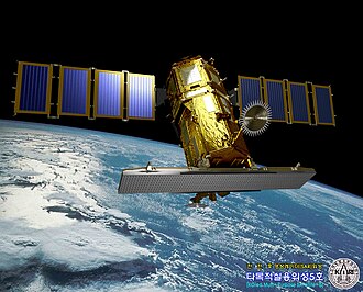
KOMPSAT-5 (Korean Multi-purpose Satellite-5), also known as Arirang-5, is a South Korean observation satellite launched by Korea Aerospace Research Institute on August 22, 2013. It is a low-orbit satellite with an operational orbit of 550 km.
Development
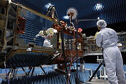
KOMPASAT-5 was developed with a total project cost of 238.1 billion won from June 2005. The Ministry of Science, ICT and Future Planning, the Ministry of Trade, Industry and Energy, etc. jointly initiated the project, and related industries such as the Korea Aerospace Research Institute, Korea Aerospace Industries, Korean Air, Hanwha, Doosan Heavy Industries, and Satrec Initiative participated in the development.[1]
Technology
It is the first South Korean satellite to be equipped with a synthetic-aperture radar, making it an all-weather Earth observation satellite that can precisely observe the Earth in high resolution even in bad weather such as cloudy days and at night. Its operational orbit is 550 km.[1]
While the existing KOMPSAT-2 and KOMPSAT-3 use visible light and they cannot observe the ground on dark nights or cloudy days, KOMPSAT-5 is equipped with a SAR uses microwaves and can penetrate clouds.[1]
Mission
การพัฒนาเสร็จสมบูรณ์ในปี 2010 แต่การปล่อยถูกเลื่อนออกไปนานกว่าสองปี ในที่สุดก็ถูกปล่อยขึ้นสู่อวกาศจากฐานปล่อยยานยาซนีเวลา 20:39 น. (23:39 น. ตามเวลาเกาหลี ) ในวันที่ 22 สิงหาคม 2013 และประสบความสำเร็จในการติดต่อครั้งแรกกับสถานีดาวเทียมโทรลล์ ประมาณ 32 นาทีหลังจากการปล่อย[ 2 ] 1 ชั่วโมง 27 นาทีหลังจากการปล่อย ก็สามารถติดต่อสื่อสารกับสถานีภาคพื้นดินในสฟาลบาร์ดประเทศนอร์เวย์ได้สำเร็จ และ 5 ชั่วโมง 56 นาทีต่อมา (05:36 น. ตามเวลาเกาหลี) ก็สามารถติดต่อสื่อสารกับสถานีภาคพื้นดินที่ศูนย์วิจัยข้อมูลดาวเทียม KARI ในแดจอน ได้สำเร็จ ซึ่งเป็นการยืนยันความสำเร็จของการปล่อย[ 1 ]
ภารกิจหลักคือการสังเกตการณ์คาบสมุทรเกาหลีวันละสองครั้ง ทั้งกลางวันและกลางคืน จากระดับความสูง 550 กิโลเมตร เพื่อติดตามภัยพิบัติ เช่น การรั่วไหลของน้ำมันในทะเลและการระเบิดของภูเขาไฟ และเพื่อสร้างระบบสารสนเทศทางภูมิศาสตร์สามารถถ่ายภาพที่มีความละเอียดสูงถึง 1 เมตรเมื่อปรับเทียบแล้ว[ 1 ]
ณ เดือนสิงหาคม พ.ศ. 2561 ยานอวกาศโคจรรอบโลกประมาณ 27,000 ครั้งในช่วงห้าปี สื่อสารกับสถานีภาคพื้นดิน 7,000 ครั้ง และให้ภาพถ่ายมากกว่า 127,000 ภาพจากทั้งหมด 58,440 ภาพ โดยเฉพาะอย่างยิ่ง ภาพที่ถ่ายในสถานการณ์ภัยพิบัติ เช่น น้ำท่วม ภัยแล้ง ไฟป่า แผ่นดินไหว และการรั่วไหลของน้ำมันในทะเล ได้รับการประเมินว่าเป็นประโยชน์อย่างมากในการตอบสนองอย่างรวดเร็ว และภาพเหล่านี้ยังถูกส่งมอบให้กับหน่วยงานภาครัฐและเอกชนต่างๆ ที่เกี่ยวข้องกับความปลอดภัยสาธารณะและการจัดการที่ดินและทรัพยากรอีกด้วย[ 3 ]
เดิมทีมีการเปิดตัวโดยมีภารกิจอายุการใช้งาน 5 ปี และมีเป้าหมายในการดำเนินงานจนถึงวันที่ 22 สิงหาคม 2561 อย่างไรก็ตาม ในเดือนสิงหาคม 2561 คณะกรรมการตรวจสอบที่จัดตั้งขึ้นโดยกระทรวงวิทยาศาสตร์และเทคโนโลยีสารสนเทศและ KARI ได้ทำการตรวจสอบทางเทคนิคและพบว่าสามารถดำเนินภารกิจต่อไปได้อีก จึงขยายระยะเวลาการดำเนินงานออกไปอีก 2 ปี[ 3 ]