
Lake Amadeus
| Lake Amadeus(Pantu) | |
|---|---|
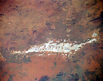 From space (November 1994) | |
  Lake Amadeus(Pantu) | |
| Location | Petermann, Northern Territory[1] |
| Coordinates | 24°45′00″S130°55′00″E / 24.75°S 130.9167°E / -24.75; 130.9167[1] |
| Type | Salt lake |
| Basin countries | Australia |
| Max. length | 180 km (110 mi) |
| Max. width | 10 km (6.2 mi) |
Surface area | 1,032 km2 (398 sq mi) |
Lake Amadeus (together with Lake Neale, Pitjantjatjara: Pantu[2][3][4] ("salt lakes") is a large salt lake in the southwest corner of Northern Territory of Australia, about 50 kilometres (31 mi) north of Uluru. The smaller Lake Neale is adjacent to the northwest. It is part of (or a surface feature of) the Amadeus Basin that was filled with the erosion products of the Petermann Orogeny.
Physical features
Due to the aridity of the area, the surface of Lake Amadeus is usually a dry salt crust. While the underground Amadeus Basin flows east to the Pedirka Basin and Warburton Basin, if full, Lake Amadeus would drain west to Lake Hopkins, and then, like Lake Lewis, would flow-on to Lake MacDonald, Lake Mackay, Lake Wills and Lake White before turning east and eventually joining the Victoria River, which in turn flows into the Timor Sea.
Lake Amadeus is 180 kilometres (110 mi) long and 10 kilometres (6.2 mi) wide, making it the largest salt lake in the Northern Territory.[5]
Lake Amadeus contains up to 600 million tonnes of salt; however, harvesting it has not proved viable, owing to its remote location.
History
Lake Amadeus is on Aboriginal land, and is covered by the Katiti and Petermann Aboriginal Land Trusts.[6]
ชาวยุโรปคนแรกที่มาถึงทะเลสาบแห่งนี้คือนักสำรวจErnest Gilesซึ่งพบทะเลสาบนี้ในปี 1872 เดิมที Giles ตั้งใจจะตั้งชื่อทะเลสาบนี้เพื่อเป็นเกียรติแก่ผู้มีพระคุณของเขาคือ Baron Ferdinand von Muellerว่าLake Ferdinandอย่างไรก็ตาม Mueller ได้ขอร้องให้ Giles ตั้งชื่อทะเลสาบนี้เพื่อเป็นเกียรติแก่กษัตริย์Amadeo I แห่งสเปน (ครองราชย์ระหว่างปี 1870–1873 ซึ่งในภาษาอังกฤษ เรียก ว่า King Amadeus I) ผู้ซึ่งเคยให้เกียรติแก่เขามาก่อน ความกว้างใหญ่ของทะเลสาบเป็นอุปสรรคสำหรับ Giles ซึ่งสามารถมองเห็นทั้งUluruและKata Tjutaได้ แต่ไม่สามารถไปถึงได้เนื่องจากพื้นทะเลสาบที่แห้งไม่สามารถรองรับน้ำหนักของม้าของเขาได้[ 7 ] ในปีต่อมาWilliam Gosseได้ปีนขึ้นไปและตั้งชื่อเนินเขาทั้งสองแห่ง
ตำนาน
ตำนานเล่าว่าpantuถูกสร้างขึ้นโดยwanampi (งูน้ำ) ตามที่ Paddy Uluru ผู้เฒ่า Anangu ผู้ล่วงลับได้บรรยายไว้ว่า "wanampi ได้ขุดพื้นดินด้วยไม้เพื่อสร้างทะเลสาบ และวาดวงกลมซ้อนกันบนพื้นดิน" [ 8 ]