
ทะเลสาบอันซา
| ทะเลสาบอันซา | |
|---|---|
 | |
  ทะเลสาบอันซา  ทะเลสาบอันซา | |
| ที่ตั้ง | เคาน์ตีคอนทราคอสตา รัฐแคลิฟอร์เนีย |
| พิกัด | 37°53′46″N 122°15′01″W / 37.89610°N 122.25033°W / 37.89610; -122.25033 |
| พิมพ์ | อ่างเก็บน้ำ |
| ไวล์ดแคทครีก | |
| ไวล์ดแคทครีก | |
| 1.56 ตาราง ไมล์ (4.0 ตาราง กิโลเมตร) | |
| ประเทศในลุ่มน้ำ | สหรัฐอเมริกา |
พื้นที่ผิว | 10 เอเคอร์ (4.0 เฮกตาร์) |
ระดับความสูงของพื้นผิว | 794 ฟุต (242 เมตร) |
ทะเลสาบอันซาเป็นอ่างเก็บน้ำสำหรับว่ายน้ำ เพื่อการพักผ่อนหย่อนใจ ตั้งอยู่ในอุทยานภูมิภาคทิลเดนในเนินเขาเบิร์กลีย์เหนือ เมืองเบิร์กลีย์ รัฐแคลิฟอร์เนีย
ประวัติศาสตร์

ทะเลสาบนี้เกิดขึ้นจากการก่อสร้างเขื่อน CL Tilden Parkในปี 1938 [ 1 ] คณะกรรมการอุทยานภูมิภาคอีสต์เบย์ตั้งชื่อทะเลสาบนี้เพื่อเป็นเกียรติแก่นักสำรวจชาวสเปนJuan Bautista de Anza [ 2 ]
ทะเลสาบอันซาถูกสร้างขึ้นในปี 1938 โดยได้รับเงินทุนจากสำนักงานบริหารงานสาธารณะ (PWA) เพื่อเป็นทะเลสาบเพื่อการพักผ่อนหย่อนใจ และยังเป็นแหล่งน้ำสำหรับสนามกอล์ฟทิลเดนพาร์คด้วย แม้ว่าปัจจุบันสนามกอล์ฟจะไม่ได้ใช้น้ำจากทะเลสาบอันซาแล้ว แต่ระบบน้ำก็ยังคงอยู่ ชายหาดและโรงอาบน้ำหินถูกสร้างขึ้นโดยสำนักงานบริหารงานความก้าวหน้า (WPA) โรงอาบน้ำหินของ WPA เดิมถูกไฟไหม้ในช่วงทศวรรษ 1960 และถูกแทนที่ด้วยอาคารปัจจุบัน[ 3 ]
สิ่งอำนวยความสะดวก


Tilden Little Farm
[[File:Tilden Regional Park little farm.jpg|250px]]\", \"description\": \"The Little Farm at Tilden Regional park is a model farm that includes various livestock. ([https://geohack.toolforge.org/geohack.php?params=37.9099;-122.2656_dim:2000 37.9099,-122.2656])\", \"marker-symbol\": \"-number-F84356\", \"marker-size\": \"medium\", \"marker-color\": \"#dfdf4f\" }, \"geometry\": {\"type\": \"Point\", \"coordinates\": [-122.2656,37.9099] } }, { \"type\": \"Feature\", \"properties\": { \"title\": \"2
[[Tilden Park Merry-Go-Round]]
[[File:0399 Ceiling Detail (29622931445).jpg|250px]]\", \"description\": \"The 1911 [[Allan Herschell Company|Herschel-Spillman]] carousel was originally installed in Urbita Springs and was moved to Tilden in 1948. ([https://geohack.toolforge.org/geohack.php?params=37.9008;-122.2561_dim:2000 37.9008,-122.2561])\", \"marker-symbol\": \"-number-F84356\", \"marker-size\": \"medium\", \"marker-color\": \"#dfdf4f\" }, \"geometry\": {\"type\": \"Point\", \"coordinates\": [-122.2561,37.9008] } }, { \"type\": \"Feature\", \"properties\": { \"title\": \"3
Inspiration Point
[[File:Inspiration point view 1.jpg|250px]]\", \"description\": \"Inspiration Point serves as the trailhead for the Nimitz Way trail. ([https://geohack.toolforge.org/geohack.php?params=37.9055;-122.2443_dim:2000 37.9055,-122.2443])\", \"marker-symbol\": \"-number-F84356\", \"marker-size\": \"medium\", \"marker-color\": \"#dfdf4f\" }, \"geometry\": {\"type\": \"Point\", \"coordinates\": [-122.2443,37.9055] } }, { \"type\": \"Feature\", \"properties\": { \"title\": \"4
[[Lake Anza]]
[[File:P20161020-0002—Lake Anza—Tilden Regional Park.jpg-1 (30406885812).jpg|250px]]\", \"description\": \"Lake Anza was formed by the Charles Lee Tilden Park Dam in 1938. ([https://geohack.toolforge.org/geohack.php?params=37.8963;-122.2502_dim:2000 37.8963,-122.2502])\", \"marker-symbol\": \"-number-F84356\", \"marker-size\": \"medium\", \"marker-color\": \"#dfdf4f\" }, \"geometry\": {\"type\": \"Point\", \"coordinates\": [-122.2502,37.8963] } }, { \"type\": \"Feature\", \"properties\": { \"title\": \"5
Brazilian Room
[[File:Brazilian Room (Brazil Building) - Tilden Regional Park, Berkeley, California - DSC04247.JPG|250px]]\", \"description\": \"Wood for the Brazilian Room was originally used in the Brazilian Pavilion for the 1939 Golden Gate International Exhibition on Treasure Island. ([https://geohack.toolforge.org/geohack.php?params=37.8937;-122.2454_dim:2000 37.8937,-122.2454])\", \"marker-symbol\": \"-number-F84356\", \"marker-size\": \"medium\", \"marker-color\": \"#dfdf4f\" }, \"geometry\": {\"type\": \"Point\", \"coordinates\": [-122.2454,37.8937] } }, { \"type\": \"Feature\", \"properties\": { \"title\": \"6
[[Regional Parks Botanic Garden]]
[[File:Regional Parks Botanic Garden - Berkeley, CA - DSC04501.JPG|250px]]\", \"description\": \"Regional Parks Botanic Garden showcases California native plants. ([https://geohack.toolforge.org/geohack.php?params=37.8926;-122.243_dim:2000 37.8926,-122.243])\", \"marker-symbol\": \"-number-F84356\", \"marker-size\": \"medium\", \"marker-color\": \"#dfdf4f\" }, \"geometry\": {\"type\": \"Point\", \"coordinates\": [-122.243,37.8926] } }, { \"type\": \"Feature\", \"properties\": { \"title\": \"7
[[Tilden Park Golf Course]]
\", \"description\": \" ([https://geohack.toolforge.org/geohack.php?params=37.8879;-122.2434_dim:2000 37.8879,-122.2434])\", \"marker-symbol\": \"-number-F84356\", \"marker-size\": \"medium\", \"marker-color\": \"#dfdf4f\" }, \"geometry\": {\"type\": \"Point\", \"coordinates\": [-122.2434,37.8879] } }, { \"type\": \"Feature\", \"properties\": { \"title\": \"8
[[Redwood Valley Railway]]
[[File:Number 5 Prepared to Depart (3050066754).jpg|250px]]\", \"description\": \"Redwood Valley Railway is a rideable miniature railroad. ([https://geohack.toolforge.org/geohack.php?params=37.8798;-122.2218_dim:2000 37.8798,-122.2218])\", \"marker-symbol\": \"-number-F84356\", \"marker-size\": \"medium\", \"marker-color\": \"#dfdf4f\" }, \"geometry\": {\"type\": \"Point\", \"coordinates\": [-122.2218,37.8798] } }, { \"type\": \"Feature\", \"properties\": { \"title\": \"9
[[Blake Garden (Kensington, California)|Blake Garden]]
[[File:Blake House (University of California Presidential Residence).jpg|250px]]\", \"description\": \"Reflecting pool and Blake House ([https://geohack.toolforge.org/geohack.php?params=37.9144;-122.285_dim:2000 37.9144,-122.285])\", \"marker-symbol\": \"-number-F84356\", \"marker-size\": \"medium\", \"marker-color\": \"#0f0f8f\" }, \"geometry\": {\"type\": \"Point\", \"coordinates\": [-122.285,37.9144] } }, { \"type\": \"Feature\", \"properties\": { \"title\": \"10
[[Indian Rock Park]]
[[File:Indian Rock Park, Berkeley, Treppe.JPG|250px]]\", \"description\": \"Indian Rock is the large rhyolite formation that gives its name to the park. ([https://geohack.toolforge.org/geohack.php?params=37.8924;-122.2726_dim:2000 37.8924,-122.2726])\", \"marker-symbol\": \"-number-F84356\", \"marker-size\": \"medium\", \"marker-color\": \"#0f0f8f\" }, \"geometry\": {\"type\": \"Point\", \"coordinates\": [-122.2726,37.8924] } }, { \"type\": \"Feature\", \"properties\": { \"title\": \"11
[[Berkeley Rose Garden]]
[[File:Berkeley Rose Garden.jpg|250px]]\", \"description\": \"Terraced planters at Berkeley Rose Garden ([https://geohack.toolforge.org/geohack.php?params=37.8854;-122.2623_dim:2000 37.8854,-122.2623])\", \"marker-symbol\": \"-number-F84356\", \"marker-size\": \"medium\", \"marker-color\": \"#0f0f8f\" }, \"geometry\": {\"type\": \"Point\", \"coordinates\": [-122.2623,37.8854] } }, { \"type\": \"Feature\", \"properties\": { \"title\": \"12
[[Lawrence Hall of Science]]
[[File:LawrenceHallofScience2007.jpg|250px]]\", \"description\": \"Lawrence Hall of Science is a popular destination for field trips from local schools. ([https://geohack.toolforge.org/geohack.php?params=37.8803;-122.2463_dim:2000 37.8803,-122.2463])\", \"marker-symbol\": \"-number-F84356\", \"marker-size\": \"medium\", \"marker-color\": \"#0f0f8f\" }, \"geometry\": {\"type\": \"Point\", \"coordinates\": [-122.2463,37.8803] } }, { \"type\": \"Feature\", \"properties\": { \"title\": \"13
[[San Pablo Reservoir]]
[[File:San Pablo and Briones Reservoirs aerial.jpg|250px]]\", \"description\": \"San Pablo (larger) and Briones (smaller) reservoirs ([https://geohack.toolforge.org/geohack.php?params=37.9133;-122.2291_dim:2000 37.9133,-122.2291])\", \"marker-symbol\": \"-number-F84356\", \"marker-size\": \"medium\", \"marker-color\": \"#0f0f8f\" }, \"geometry\": {\"type\": \"Point\", \"coordinates\": [-122.2291,37.9133] } } ] } ]"}}">
- สถานที่น่าสนใจ
- สวนสาธารณะและพิพิธภัณฑ์ใกล้เคียง
บริเวณทะเลสาบมีสิ่งอำนวยความสะดวกต่างๆ เช่น ห้องเปลี่ยนเสื้อผ้า ห้องน้ำ ( ห้องสุขา ) และที่จอดรถขนาดใหญ่ นอกจากนี้ยังมีพื้นที่รอบทะเลสาบที่สงวนไว้สำหรับนกน้ำ และพื้นที่อื่นๆ สำหรับสุนัขด้วย
ทะเลสาบเปิดให้ว่ายน้ำได้ตั้งแต่เดือนพฤษภาคมถึงกันยายน ในช่วงเวลานี้จะต้องเสียค่าเข้าชม มีเจ้าหน้าที่รักษาความปลอดภัยคอยดูแล และมีร้านขายอาหารว่างเปิดให้บริการ พื้นที่ว่ายน้ำจำกัดเฉพาะบริเวณน้ำที่อยู่ติดกับหาดทรายและหญ้าซึ่งมีความยาวประมาณ70 หลา (64 เมตร)มีพื้นที่ว่ายน้ำสำหรับผู้ใหญ่ที่มีความยาว44 หลา (40 เมตร ) [ 4 ]
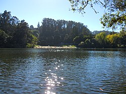 ชายหาดที่ทะเลสาบอันซา
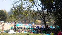 ชายหาดที่ทะเลสาบอันซา
ดูเพิ่มเติม
ลิงก์ภายนอก

- แผนที่ทะเลสาบอันซา จากFindlakes ที่ถูกเก็บถาวรเมื่อวันที่ 11 กรกฎาคม 2011 บนWayback Machine
- ทะเลสาบอันซา
- ระบบข้อมูลชื่อทางภูมิศาสตร์ของสำนักงานสำรวจทางธรณีวิทยาแห่งสหรัฐอเมริกา: ทะเลสาบอันซา
 | บทความเกี่ยวกับเทศมณฑลคอนทราคอสตา รัฐแคลิฟอร์เนียนี้ ยัง ไม่สมบูรณ์คุณสามารถช่วยวิกิพีเดียได้โดยการเพิ่มข้อมูลที่ขาดหายไป |