
Eastern Province (Kenya)
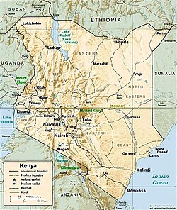
The Eastern Province (Swahili: Mashariki) of Kenya was one of 8 Provinces of Kenya. Its northern boundary ran along with that of Ethiopia; the North Eastern Province and Coast Province lay to the east and south; and the remainder of Kenya's provinces, including Central Province, ran along its western border. The provincial capital was Embu.
Overview
On 16 July 2009, the province was sub-divided into three: Lower Eastern with Machakos as headquarters, Central Eastern with Embu as headquarters, and Upper Eastern with Marsabit as headquarters; however, those changes never took effect due to the political wrangles in the Kenyan coalition government at the time. The sub-division of provinces was carried out in seven provinces of Kenya, excluding Nairobi. As of March 2013 after the Kenyan general election, 2013, the Eastern Province was subdivided into eight counties, namely:
| Code | County | Area (km2) | Populationcensus 2009 | Capital |
|---|---|---|---|---|
| 10 | Marsabit | 66,923.1 | 291,166 | Marsabit |
| 11 | Isiolo | 25,336.1 | 143,294 | Isiolo |
| 12 | Meru | 7,003 | 1,356,301 | Meru |
| 13 | Tharaka-Nithi | 2,609.5 | 365,330 | Chuka |
| 14 | Embu | 2,555.9 | 516,212 | Embu |
| 15 | Kitui | 24,385.1 | 1,012,709 | Kitui |
| 16 | Machakos | 5,952.9 | 1,098,584 | Machakos |
| 17 | Makueni | 8,008.9 | 884,527 | Wote |
| Totals | 140,698.6 | 5,668,123 | - |
The province was principally inhabited by the Meru, Kamba, Embu, and several pastoralist communities. In 1979, its population was 2.7 million; in 1999, 4,631,779 (according to the 1999 census) and in 2009 the province would have had a population of 5,668,123.[2] In terms of area, it was the second largest province at (140,698.6 km2) in Kenya.
Geography
Eastern Province of Kenya includes the Chalbi Desert, Mount Kenya, and the eastern half of Lake Turkana. The climate in the region is arid to semi-arid. Its most important permanent river is Ewaso Ng'iro.
Villages and settlements
- Beacon Ranch
- Chematu
- Chiakariga
- Chiananda
- Chomboni
- Ekarakara
- El Dera
- Embori Farm
- Gakwegore
- Goriva
- Gatundori
- Gatunga
- Gekuuri
- Gethemu
- Gitare
- Ianzoni
- Igumori
- Iiuni
- Ikarakara
- Ikoo
- Imale
- Inghi Farm
- Inyokoni
- Isuvya
- Itetani
- Ithemboni
- Ithoku
- อิตูกูรูรุ
- จาโนนี
- คาเธเน่
- คาคูนิเก
- คาคุนิโอะ
- ไคเล็มบวา
- ไครูริ
- คาคาเลีย
- กากังกานี
- คาลิมบูอิ
- คาลูลินี
- คามาเอนเด
- กัมปิ-ยา-ชุมวี
- กัมบี ยา มุนยู
- คัมปิ ยา จู
- กามุตวา
- คานิงโก
- คันจูกิ
- คานเยกีน
- คาริงกาเร
- คารูอัมกี
- คารัวรี
- คาร์วิโร
- ซาฟารี
- กาไซนี
- คาซิเลีย
- คาซิโอโคนี
- คาเตเลมบู
- คาเทเน่
- กาทังการารี
- กาทังการี
- คาเทก้า
- คาเธนาอูกิ
- คาทูกู
- คาธุนกู
- คาโทเทีย
- กาตุลเย
- กาวูรูริ
- คาวียองโก
- กวันจาโร
- คาเวลู
- เคกา
- เคนเพลนส์
- เคอรี่
- เควันดา
- เคโวเต้
- คิอามูริงกา
- เคียงกุนกิ
- เคียเนีย
- คิอานิโอโคมา
- คิอันจูกิ
- คิอาติเนนี
- คิโบกิ
- คิบูกวา
- คิเจกเก้
- คิคุ
- คิลาวา
- คิมู
- พื้นที่เลี้ยงสัตว์คินยาตะ
- คิริมาริ
- คิริติริ
- คิตันดี
- คิทังกาธินี
- ครัว
- คิทุงกูริ
- คิตู
- คิตูเต้
- คิวุมบู
- คอมโบยู
- คิวโซ
- ควากาวิซี
- ควานเดเก้
- ควา คิเตา
- ควา มาคูลี
- Kwa Ukungu
- โลโก้ Log
- ฟาร์มโลโลมาริก
- มาโดะ ยากะ
- ไมคู
- ไมยูนี
- มาคาเบเต้
- มาเคนจิ
- มากินย่า
- มาลิบานี
- มาลิมา
- มัลก้า มารี
- แมนดองโกย
- มังเกเลเต
- มาโนนี
- มาเปปี
- มาซิมบานี
- มาซอนโกเลนี
- มาวินดู
- เอ็มเบโวนี
- มบูวู
- มิเทมบูกา
- มิตุนกูกู
- มคาปูวันซี
- มูบูโกะ
- มูชีน
- มูชูโม
- มูลาล่า
- มูริงการี
- มูชัมบา
- มูซิกิโอ
- มูตูเลีย
- มูทูน
- มวังกาเรเม
- มวางินี
- มวัมบาธานา
- มเว
- มเวเว
- Ndooa
- เนมบูเร
- นชิมวานี
- งันดานี
- งันดูเร
- งาริรา
- งาทูน
- งิโอริ
- งโกสินีตะวันออก
- งโกสินีตะวันตก
- งโกวี
- งูชิชิ
- งู
- งูนิ
- งวาเต้
- ซาริโช
- สควาตา
- ซุมบุนกู
- อุซูเอนี