
เทศบาลมาร์นาร์ดาล
เทศบาลมาร์นาร์ดาล เทศบาลมาร์นาร์ดาล | |
|---|---|
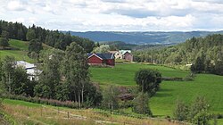
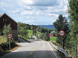 ภาพมุมมองของพื้นที่มาร์นาร์ดาล | |
 เวสต์-อาดเดอร์ ในประเทศนอร์เวย์ | |
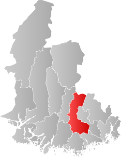 มาร์นาร์ดาลภายในเวสต์-แอกเดอร์ | |
| พิกัด: 58°14′34″เหนือ07°29′49″ตะวันออก / 58.24278°N 7.49694°E | |
| ประเทศ | นอร์เวย์ |
| เขต | เวสต์-แอกเดอร์ |
| เขต | ซอร์แลนด์ |
| ที่จัดตั้งขึ้น | 1 มกราคม 2507 |
| • นำหน้าด้วย | เทศบาลเมืองเลาดาลและเทศบาลØyslebø |
| ยุบเลิกแล้ว | 1 มกราคม 2563 |
| • สืบทอดตำแหน่งต่อจาก | เทศบาลลินเดสเนส |
| ศูนย์บริหาร | เฮดเดแลนด์ |
| รัฐบาล | |
| • นายกเทศมนตรี(ปี 2007–2019) | เฮลเก ซานดาเคอร์ ( เอพี ) |
| พื้นที่ (เมื่อสลายตัว) | |
• ทั้งหมด | 395.01 ตารางกิโลเมตร( 152.51 ตารางไมล์) |
| • ที่ดิน | 375.89 ตารางกิโลเมตร( 145.13 ตารางไมล์) |
| • น้ำ | 19.12 ตารางกิโลเมตร( 7.38 ตารางไมล์) 4.8% |
| • อันดับ | อันดับที่ 240 ในนอร์เวย์ |
| ระดับความสูงสูงสุด | 511.7 เมตร (1,679 ฟุต) |
| ประชากร (2019) | |
• ทั้งหมด | 2,297 |
| • อันดับ | อันดับที่ 306 ในนอร์เวย์ |
| • ความหนาแน่น | 6.1/กม. ² (16/ตร.ไมล์) |
| • การเปลี่ยนแปลง(10 ปี) |  +3.3% +3.3% |
| ประชาชาติ | มาร์นาร์ดอล[ 2 ] |
| ภาษาทางการ | |
| • รูปแบบภาษานอร์เวย์ | เป็นกลาง |
| เขตเวลา | UTC+01:00 ( CET ) |
| • ฤดูร้อน ( เวลาออมแสง ) | UTC+02:00 ( CEST ) |
| รหัส ISO 3166 | หมายเลข 1021 [ 4 ] |
ข้อมูลจากสำนักงานสถิตินอร์เวย์ | |
มาร์นาร์ดาลเป็นอดีตเทศบาลในเขตเวสต์-อักเดอร์ เดิม ของประเทศนอร์เวย์เทศบาลแห่งนี้มีพื้นที่ 395 ตารางกิโลเมตร (153 ตารางไมล์) ดำรงอยู่ตั้งแต่ปี 1964 จนกระทั่งถูกยุบในปี 2020 ปัจจุบันพื้นที่นี้เป็นส่วนหนึ่งของเทศบาลลินเดสเนสใน เขต ซอร์ลันเดตดั้งเดิมของเขตอักเดอร์ศูนย์กลางการบริหารคือหมู่บ้าน เฮด เดลันด์หมู่บ้านอื่นๆ ในเทศบาล ได้แก่บิเยลันด์เบรลันด์โคลันด์เลาดาลและออยสเลโบทางรถไฟสายซอร์ ลันเดต วิ่งผ่านเทศบาล โดยมีสถานีเบรลันด์และสถานีมาร์นาร์ดาล
Prior to its dissolution in 2020, the 395.01-square-kilometre (152.51 sq mi) municipality was the 240th largest by area out of the 422 municipalities in Norway. Marnardal Municipality was the 306th most populous municipality in Norway with a population of about 2,297. The municipality's population density was 6.1 inhabitants per square kilometre (16/sq mi) and its population had increased by 3.3% over the previous 10-year period.[5][6]
General information

During the 1960s, there were many municipal mergers across Norway due to the work of the Schei Committee.[7][8] Marnardal Municipality was established as a new municipality on 1 January 1964 through the merger of the following areas:[9]
- all of Laudal Municipality (population: 560)
- most of Øyslebø Municipality (population: 1,068), except for the Brunvatne area which became part of Søgne Municipality
- most of Bjelland Municipality (population: 535), except for the Midtbø and Ågedal areas which became part of Audnedal Municipality
- the Kleveland bru area of Finsland Municipality (population: 34), the rest of Finsland Municipality joined the new Songdalen Municipality
On 15 May 2019, the 0.7-square-kilometre (0.27 sq mi) Åsan farm (population: 4) was transferred from Marnardal Municipality to Songdalen Municipality.[10]
On 1 January 2020, another major municipal merger took place when the following areas were merged to form a much larger Lindesnes Municipality with its administrative centre being the town of Mandal:[11]
- all of Mandal Municipality (population: 15,659)
- all of Marnardal Municipality (population: 2,309)
- all of Lindesnes Municipality (population: 4,953)
Name
เทศบาลนี้ตั้งชื่อตาม หุบเขา แมนดาเลน ( ภาษานอร์สโบราณ : Marnardalr ) เพื่อพยายามฟื้นฟูชื่อภาษานอร์สโบราณของหุบเขา องค์ประกอบแรกคือรูปกรรมวาจกของชื่อแม่น้ำMǫrnซึ่งปัจจุบันเรียกว่าMandalselvaความหมายของชื่อแม่น้ำโบราณนี้ไม่แน่ชัด แต่อาจมาจากคำว่าmarrซึ่งหมายถึง " ทะเล " องค์ประกอบสุดท้ายคือdalrซึ่งหมายถึง " หุบเขา " หรือ "dale" [ 12 ]
ตราแผ่นดิน
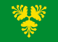
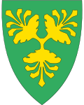
ตรา ประจำเมืองนี้ได้รับ พระราชทานเมื่อวันที่ 19 มิถุนายน 1987 จนกระทั่งเทศบาลถูกยุบเมื่อวันที่ 1 มกราคม 2020 คำอธิบาย อย่างเป็นทางการ คือ" สีเขียวลูกสนสามลูกในก้านที่เชื่อมต่อกันสีทอง " ( ภาษานอร์เวย์ : I grønt tre gull furukongler forent i trepass ) ซึ่งหมายความว่าตราประจำเมืองมีพื้น สีเขียว (พื้นหลัง) และสัญลักษณ์คือลูก สน ลูกสนมีสีทองซึ่ง หมายความว่าโดยทั่วไปแล้วจะมีสีเหลือง แต่ถ้าทำจากโลหะจะใช้สีทอง สีเขียวในพื้นและลูกสนที่เลือกใช้บนตราประจำเมืองเป็นสัญลักษณ์แสดงถึงความสำคัญของป่าไม้ที่ปกคลุมพื้นที่ของเทศบาล ตราประจำเมือง ประกอบด้วยลูกสนสามลูกที่เชื่อมต่อกันเพื่อเป็นตัวแทนของเทศบาลเดิมสามแห่ง ได้แก่Bjelland , LaudalและØyslebøซึ่งถูกรวมเข้ากับ Marnardal ในปี 1964 ตราประจำเมืองนี้ออกแบบโดย Ulf Dreyer โดยใช้แนวคิดของ Kjersti Tveit Nilsen ธงประจำเมืองมีดีไซน์เดียวกับตราประจำเมือง[ 12 ] [ 13 ] [ 14 ] [ 15 ]
โบสถ์
คริสตจักรแห่งนอร์เวย์มีสามเขตวัด ( sokn ) ภายในเทศบาลมาร์นาร์ดาล ซึ่งเป็นส่วนหนึ่งของเขตปกครอง ( deanery ) ของสังฆมณฑลอักเดอร์และเทเลมาร์ก
| เขตปกครอง ( sokn ) | ชื่อโบสถ์ | ที่ตั้งของโบสถ์ | ปีที่สร้าง |
|---|---|---|---|
| บเยลแลนด์ | โบสถ์บีเจลแลนด์ | บเยลแลนด์ | ค.ศ. 1793 |
| ลอว์ดาล | โบสถ์ลอว์ดัล | ลอว์ดาล | 1826 |
| Øyslebø | โบสถ์โอสเลโบ | Øyslebø | ค.ศ. 1797 |
รัฐบาล
While it existed, Marnardal Municipality was responsible for primary education (through 10th grade), outpatient health services, senior citizen services, welfare and other social services, zoning, economic development, and municipal roads and utilities. The municipality was governed by a municipal council of directly elected representatives. The mayor was indirectly elected by a vote of the municipal council.[16] The municipality was under the jurisdiction of the Kristiansand District Court and the Agder Court of Appeal.
Municipal council
The municipal council(Kommunestyre) of Marnardal Municipality was made up of 21 representatives that were elected to four year terms. The tables below show the historical composition of the council by political party.
| Party name (in Norwegian) | Number ofrepresentatives | |
|---|---|---|
| Labour Party(Arbeiderpartiet) | 9 | |
| Progress Party(Fremskrittspartiet) | 1 | |
| Conservative Party(Høyre) | 3 | |
| Christian Democratic Party(Kristelig Folkeparti) | 3 | |
| Centre Party(Senterpartiet) | 5 | |
| Total number of members: | 21 | |
| Note: On 1 January 2020, Marnardal Municipality became part of Lindesnes Municipality. | ||
| Party name (in Norwegian) | Number ofrepresentatives | |
|---|---|---|
| Labour Party(Arbeiderpartiet) | 8 | |
| Progress Party(Fremskrittspartiet) | 2 | |
| Conservative Party(Høyre) | 3 | |
| Christian Democratic Party(Kristelig Folkeparti) | 3 | |
| Centre Party(Senterpartiet) | 4 | |
| Liberal Party(Venstre) | 1 | |
| Total number of members: | 21 | |
| Party name (in Norwegian) | Number ofrepresentatives | |
|---|---|---|
| Labour Party(Arbeiderpartiet) | 6 | |
| Progress Party(Fremskrittspartiet) | 2 | |
| Conservative Party(Høyre) | 3 | |
| Christian Democratic Party(Kristelig Folkeparti) | 3 | |
| Centre Party(Senterpartiet) | 6 | |
| Liberal Party(Venstre) | 1 | |
| Total number of members: | 21 | |
| Party name (in Norwegian) | Number ofrepresentatives | |
|---|---|---|
| Labour Party(Arbeiderpartiet) | 7 | |
| Conservative Party(Høyre) | 3 | |
| Christian Democratic Party(Kristelig Folkeparti) | 3 | |
| Centre Party(Senterpartiet) | 6 | |
| Liberal Party(Venstre) | 2 | |
| Total number of members: | 21 | |
| Party name (in Norwegian) | Number ofrepresentatives | |
|---|---|---|
| Labour Party(Arbeiderpartiet) | 5 | |
| Progress Party(Fremskrittspartiet) | 2 | |
| Conservative Party(Høyre) | 3 | |
| Christian Democratic Party(Kristelig Folkeparti) | 4 | |
| Centre Party(Senterpartiet) | 5 | |
| Liberal Party(Venstre) | 2 | |
| Total number of members: | 21 | |
| Party name (in Norwegian) | Number ofrepresentatives | |
|---|---|---|
| Labour Party(Arbeiderpartiet) | 5 | |
| Conservative Party(Høyre) | 2 | |
| Christian Democratic Party(Kristelig Folkeparti) | 3 | |
| Centre Party(Senterpartiet) | 9 | |
| Liberal Party(Venstre) | 2 | |
| Total number of members: | 21 | |
| Party name (in Norwegian) | Number ofrepresentatives | |
|---|---|---|
| Labour Party(Arbeiderpartiet) | 4 | |
| Conservative Party(Høyre) | 3 | |
| Christian Democratic Party(Kristelig Folkeparti) | 2 | |
| Centre Party(Senterpartiet) | 8 | |
| Liberal Party(Venstre) | 1 | |
| Marnardal local list(Marnardal bygdeliste) | 3 | |
| Total number of members: | 21 | |
| Party name (in Norwegian) | Number ofrepresentatives | |
|---|---|---|
| Labour Party(Arbeiderpartiet) | 5 | |
| Conservative Party(Høyre) | 4 | |
| Christian Democratic Party(Kristelig Folkeparti) | 3 | |
| Centre Party(Senterpartiet) | 4 | |
| Joint list of the Liberal Party(Venstre) andLiberal People's Party (Liberale Folkepartiet) | 2 | |
| Marnardal local list(Marnardal Bygdeliste) | 3 | |
| Total number of members: | 21 | |
| Party name (in Norwegian) | Number ofrepresentatives | |
|---|---|---|
| Labour Party(Arbeiderpartiet) | 5 | |
| Conservative Party(Høyre) | 3 | |
| Christian Democratic Party(Kristelig Folkeparti) | 3 | |
| Centre Party(Senterpartiet) | 5 | |
| Joint list of the Liberal Party(Venstre) andLiberal People's Party (Liberale Folkepartiet) | 1 | |
| Marnardal local list(Marnardal Bygdelista) | 4 | |
| Total number of members: | 21 | |
| Party name (in Norwegian) | Number ofrepresentatives | |
|---|---|---|
| Labour Party(Arbeiderpartiet) | 4 | |
| Conservative Party(Høyre) | 3 | |
| Christian Democratic Party(Kristelig Folkeparti) | 3 | |
| Centre Party(Senterpartiet) | 6 | |
| รายชื่อร่วมของพรรคเสรีนิยม(Venstre)และพรรคประชาชนใหม่(Nye Folkepartiet) | 1 | |
| รายการท้องถิ่น Marnardal (Marnardal bygdeliste) | 4 | |
| จำนวนสมาชิกทั้งหมด: | 21 | |
| ชื่อพรรค(ภาษานอร์เวย์) | จำนวนผู้แทน | |
|---|---|---|
| พรรคแรงงาน(Arbeiderpartiet) | 6 | |
| พรรคอนุรักษ์นิยม(Høyre) | 2 | |
| พรรคคริสเตียนประชาธิปไตย(คริสเตลิก โฟลเกปาร์ตี) | 4 | |
| พรรคประชาชนใหม่(Nye Folkepartiet) | 1 | |
| พรรคกลาง(Senterpartiet) | 7 | |
| รายชื่อข้ามฝ่าย(Tverrpolitisk Liste) | 1 | |
| จำนวนสมาชิกทั้งหมด: | 21 | |
| ชื่อพรรค(ภาษานอร์เวย์) | จำนวนผู้แทน | |
|---|---|---|
| พรรคแรงงาน(Arbeiderpartiet) | 7 | |
| พรรคอนุรักษ์นิยม(Høyre) | 1 | |
| พรรคคริสเตียนประชาธิปไตย(คริสเตลิก โฟลเกปาร์ตี) | 2 | |
| พรรคกลาง(Senterpartiet) | 8 | |
| พรรคเสรีนิยม(เวนสเตร) | 3 | |
| จำนวนสมาชิกทั้งหมด: | 21 | |
| ชื่อพรรค(ภาษานอร์เวย์) | จำนวนผู้แทน | |
|---|---|---|
| พรรคแรงงาน(Arbeiderpartiet) | 6 | |
| พรรคอนุรักษ์นิยม(Høyre) | 1 | |
| พรรคคริสเตียนประชาธิปไตย(คริสเตลิก โฟลเกปาร์ตี) | 3 | |
| พรรคกลาง(Senterpartiet) | 7 | |
| พรรคเสรีนิยม(เวนสเตร) | 4 | |
| จำนวนสมาชิกทั้งหมด: | 21 | |
| ชื่อพรรค(ภาษานอร์เวย์) | จำนวนผู้แทน | |
|---|---|---|
| พรรคแรงงาน(Arbeiderpartiet) | 7 | |
| พรรคคริสเตียนประชาธิปไตย(คริสเตลิก โฟลเกปาร์ตี) | 2 | |
| พรรคกลาง(Senterpartiet) | 8 | |
| พรรคเสรีนิยม(เวนสเตร) | 4 | |
| จำนวนสมาชิกทั้งหมด: | 21 | |
นายกเทศมนตรี
นายกเทศมนตรี( ภาษานอร์เวย์ : ordfører ) ของเทศบาลเมืองมาร์นาร์ดาลเป็นผู้นำทางการเมืองของเทศบาลและเป็นประธานสภาเทศบาล บุคคลต่อไปนี้เคยดำรงตำแหน่งนี้: [ 29 ]
- 1964–1967: ยอร์เก้น ฟเยลสตัด ( V ) [ 30 ]
- 1967–1975: แม็กเน่ ฮาราลด์สตัด ( สเปน )
- 1975–1979: คริสเตน โฮลเมการ์ด ( Sp )
- 1979–1983: แม็กเน่ ฮาราลด์สตัด ( สเปน )
- 1983–1987: ทอร์กนี แซนด์แลนด์ ( KrF )
- 1987–1991: เคเจล จอห์นเซ่น ( H )
- 1991–1999: Åse Marit Bue ( สเปน )
- 1999–2007: โอเนน ทริกส์แลนด์ ( สเปน )
- 2007–2019: เฮลเก แซนโดเกอร์ ( เอพี )
ภูมิศาสตร์
มาร์นาร์ดาลเป็นเทศบาลที่อยู่ภายในแผ่นดิน ซึ่งทอดยาวไปตาม แม่น้ำมัน ดาลเซลวาผ่าน หุบเขา มันดาเลนเทศบาลแห่งนี้มีพรมแดนติดกับเทศบาลเอฟเยอ็อกฮอร์นเนสทางทิศเหนือในเขตออสต์- อักเดอร์ เทศบาล ออดเนดาล ทาง ทิศตะวันตก เทศบาลลินเดสเนสเทศบาลมันดาลและเทศบาลโซเนทางทิศใต้ และเทศบาลซงดาเลนและเทศบาลเวนเนสลาทางทิศตะวันออก จุดที่สูงที่สุดในเทศบาลคือภูเขาเออร์เทคแนปคนุเทน ซึ่งมีความสูง 511.7 เมตร (1,679 ฟุต) ในส่วนเหนือของเทศบาล[ 1 ]
ภูมิอากาศ
| ข้อมูลสภาพภูมิอากาศสำหรับเมืองบีเยลแลนด์ | |||||||||||||
|---|---|---|---|---|---|---|---|---|---|---|---|---|---|
| เดือน | ม.ค | กุมภาพันธ์ | มีนาคม | เมษายน | อาจ | จุน | กรกฎาคม | ส.ค. | กันยายน | ตุลาคม | พฤศจิกายน | ธันวาคม | ปี |
| อุณหภูมิเฉลี่ยรายวัน °C (°F) | −2.5 (27.5) | −2.7 (27.1) | 0.0 (32.0) | 3.5 (38.3) | 9.8 (49.6) | 14.0 (57.2) | 15.2 (59.4) | 14.5 (58.1) | 10.2 (50.4) | 6.7 (44.1) | 2.2 (36.0) | −1.0 (30.2) | 5.8 (42.4) |
| ปริมาณน้ำฝนเฉลี่ย(มม./นิ้ว) | 146 (5.7) | 104 (4.1) | 104 (4.1) | 64 (2.5) | 95 (3.7) | 84 (3.3) | 100 (3.9) | 128 (5.0) | 168 (6.6) | 198 (7.8) | 182 (7.2) | 142 (5.6) | 1,515 (59.6) |
| แหล่งที่มา: สถาบันอุตุนิยมวิทยานอร์เวย์[ 31 ] | |||||||||||||