
Monte Sautron
The Monte Sautron (3,166 m) is a mountain of the Cottian Alps, located between the Italian Valle Maira and the French Ubaye Valley.[1]
Characteristics
The mountain rises on the main Alpine watershed, at a node where several secondary ridges branch off. The summit lies on the Italy-France border and is shared between the Italian municipality of Acceglio and the French municipality of Larche.[1]
The main Alpine ridge arrives from the northwest, from the Colle della Portiola, and ascends to the summit; here it turns south, descending toward Monte Vallonasso, where it bends southwest again to reach the Colle del Sautron. From the summit, a secondary ridge branches off in a roughly northeast direction, descending to the pass known as La Forcellina, and continues toward the Cima di Stroppia, where it turns north, forming the Rocca Bianca group. Another ridge branches from the summit northward, sloping down toward the Val di Stroppia, which descends from the Colle della Portiola toward the Valle Maira. The French slope features a less pronounced rib descending east-southeast toward the head of the Vallon de Viraysse.[1][2]
The mountain’s elevation is reported differently in national cartographies: the Italian IGM cartography indicates an elevation of 3,166 m, while the French IGN cartography indicates 3,155 m.[2]
From a geological perspective, the mountain consists of a relatively homogeneous mass of dolomitic limestones and dolomites from the Triassic, belonging to the Briançonnais zone; to the north, carbonaceous schists, calcareous argillites, and dolomitic breccias, also Triassic, belonging to the same complex, emerge.[3] This formation rests on a base of calcschists from the Late Cretaceous - Eocene, outcropping at the base on the French slope.[4]
ชื่อภาษาฝรั่งเศสTête de Sautronสะท้อนถึงชื่อสถานที่Sautronชื่อสถานที่นี้มีต้นกำเนิดมาจากภาษาอ็อกซิตันตามความเชื่อหนึ่งระบุว่าเป็นการระลึกถึงชาว ปีเอมอนเตที่ อพยพมา จำนวนมาก ซึ่งเสียชีวิตในบริเวณนี้ขณะพยายามข้ามเทือกเขาแอลป์เพื่อไปทำงานในฝรั่งเศส [ 5 ]
การปีนขึ้นสู่ยอดเขา
การปีนขึ้นครั้งแรก
การขึ้นสู่ยอดเขาครั้งแรกที่ทราบกันดีนั้น เชื่อกันว่าเป็นผลงานของ Pio Paganini วิศวกรของIstituto Geografico Militareซึ่งขึ้นถึงยอดเขาได้ในปี พ.ศ. 2420 [ 5 ]
เส้นทางปกติ
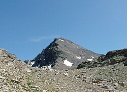
เส้นทางปกติจะตามสันเขารองที่แยกออกมาจากยอดเขาไปทางทิศเหนือ จากฝั่งอิตาลี สามารถขึ้นไปยังสันเขาได้โดยเริ่มจากหมู่บ้านChiapperaแห่งAcceglioจากนั้นขึ้นไปยังMontagna di Stroppiaตามเส้นทาง Dino Icardiแล้วเลี้ยวซ้ายตามป้ายบอกทางไปยังColle della Portiolaซึ่งบางส่วนอยู่ตามเส้นทาง Roberto Cavalleroเมื่อถึงปลายสันเขาทางเหนือ จะเริ่มปีนขึ้นไป โดยในช่วงแรกให้ชิดขวาเล็กน้อย จนกระทั่งถึงไม้กางเขนบนยอดเขา[ 1 ] [ 5 ]เส้นทางตามสันเขาบางส่วนมีเครื่องหมายสีแดง เส้นทางนี้เป็น เส้นทาง เดินป่าโดยมีระดับความยากEEตามมาตราส่วนของอิตาลี[ 1 ] [ 5 ]
เส้นทางทางเลือกอีกเส้นทางหนึ่งคือการไปถึงColle della Portiolaแล้วจึงปีนขึ้นสู่ยอดเขาจากทางสันเขาทิศตะวันตกเฉียงเหนือ[ 1 ] [ 6 ]สำหรับการปีนขึ้น สามารถใช้Rifugio StroppiaและBivacco Barenghi ใน Valle Maira เป็นที่พักได้ นอกจากนี้ยังมี Rifugio Campo BaseในChiapperaของAcceglioและRifugio ChambeyronในVallon de Chambeyronประเทศฝรั่งเศสซึ่งอยู่ไกลออกไปอีกเล็กน้อย[ 1 ] [ 6 ]
การเข้าถึงในฤดูหนาว
ในฤดูหนาว การขึ้นสู่ยอดเขาจะกลายเป็น เส้นทาง ปีนเขาด้วยสกีเส้นทางที่สะดวกที่สุดคือจากLarcheโดยขึ้นสู่ยอดเขาผ่านสันเขาจากColle della Portiola [ 1 ] [ 6 ]
บรรณานุกรม
- แผนที่ทางการของอิตาลีจาก สถาบันภูมิศาสตร์ทหาร ( Istituto Geografico Militareหรือ IGM) ในมาตราส่วน 1:25,000 และ 1:100,000 สามารถดูได้ทางออนไลน์
- แผนที่อย่างเป็นทางการของฝรั่งเศสจากสถาบันภูมิศาสตร์แห่งชาติ (IGN) สามารถดูได้ทางออนไลน์(เก็บถาวรเมื่อวันที่ 13 พฤศจิกายน 2550 ที่Wayback Machine)
- ระบบสารสนเทศทางภูมิศาสตร์ของจังหวัดคูเนโออ้างอิงจากแผนที่มาตราส่วน 1:10,000
- Istituto Geografico Centrale - แผนที่เส้นทาง 1:50,000 เลขที่ 6 " มอนวิโซ " และไม่ใช่. 7 " วัลลี ไมรา-กรานา-สตูรา "
- จังหวัดคูเนโอ - ชุมชนบนภูเขาวัลเลไมรา: แผนที่เส้นทางมาตราส่วน 1:25,000 วัลเลไมรา