
เทศบาลเมืองเนริงกา
เทศบาลเนริงกา Neringos savivaldybė | |
|---|---|
เทศบาลนคร | |
 ชายฝั่งนีด้า | |
 ธง  ตราแผ่นดิน | |
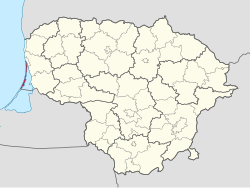 ที่ตั้งของเทศบาลเมืองเนริงกาภายในประเทศลิทัวเนีย | |
 แผนที่แบบอินเทอร์แอ็กทีฟของเทศบาลเมืองเนริงกา | |
| พิกัด: 55°33′20″N 21°07′00″E / 55.55556°N 21.11667°E / 55.55556; 21.11667 | |
| ประเทศ |  ลิทัวเนีย ลิทัวเนีย |
| ภูมิภาคชาติพันธุ์วิทยา | ลิทัวเนียไมเนอร์ |
| เขต |  เขตปกครองไคลเปดา เขตปกครองไคลเปดา |
| เมืองหลวง | นีด้า |
| ตำแหน่งผู้อาวุโส | 2 |
| พื้นที่ | |
• ทั้งหมด | 90 ตาราง กิโลเมตร(35 ตารางไมล์) |
| • อันดับ | อันดับที่ 55 |
| ประชากร (2025) [ 1 ] | |
• ทั้งหมด | 4,712 |
| • อันดับ | อันดับที่ 59 |
| • ความหนาแน่น | 52/กม. (140/ตร. ไมล์) |
| • อันดับ | อันดับที่ 39-40 |
| เขตเวลา | UTC+2 ( EET ) |
| • ฤดูร้อน ( เวลาออมแสง ) | 3 โมงเช้า ( เวลาภาคตะวันออกของสหรัฐอเมริกา ) |
| รหัสโทรศัพท์ | 469 |
| ชุมชนขนาดใหญ่ | นีด้า (ประชากร 3,530 คน) |
| เว็บไซต์ | www.neringa.lt |
เนริงกา (ⓘ ) หรือเทศบาลเนริงกา(ภาษาลิทัวเนีย:Neringos savivaldybė) เป็นเทศบาลในเขตไคลเปดาทางตะวันตกสุดของประเทศลิทัวเนียประกอบด้วยหมู่บ้านหลายแห่งในในแง่ของประชากร เทศบาลแห่งนี้มีขนาดเล็กเป็นอันดับสองของประเทศ (รองจากบีร์สโตนาส)นีดาเป็นที่ตั้งของหน่วยงานราชการและเป็นชุมชนที่ใหญ่ที่สุดในเทศบาลเนริงกา
นิรุกติศาสตร์
ชื่อเมืองนี้ค่อนข้างใหม่และไม่พบในคัมภีร์โบราณในรูปแบบนี้ ชื่อนี้มาจากคำภาษาเยอรมันNeringe , Nerunge, Nehrungซึ่งเป็นคำที่มาจากคำภาษาคูโรเนียนnerija ซึ่งหมาย ถึงแหลม ยาว[ 2 ]
Until the 2000 Lithuanian municipality reform, it was known as Neringa City, although there was never a true "city" there. It was made a city in the Soviet Union in 1961 by formally combining 4 settlements into one administrative unit.
Geography
Neringa is located south of Klaipėda, separated from the mainland Lithuania by Curonian Lagoon. It is accessible from the mainland Lithuania by ferry crossing the lagoon or overland through Kaliningrad Oblast, Russia.
The villages in Neringa municipality comprise:
- the self-governing resort settlement (kurortas) of Nida, seat of the local administration
- the eldership (seniūnija) of Juodkrantė
- the eldership of Preila and Pervalka.
They are tourist resorts and by then it was popular to grant more self-government to resorts. The municipality is the only one in Lithuania which is not called after a town or city. The name Neringa was created at Soviet time for the new city municipality.
History
Since 1252 the region was part of the State of the Teutonic Knights. In 1454, Polish King Casimir IV Jagiellon incorporated the region to the Kingdom of Poland upon the request of the Prussian Confederation – a league formed in opposition to the Teutonic Order.[3] After the subsequent Thirteen Years' War (1454–1466), the Teutonic Order regained authority over the town as a fief of the Polish Crown.[4][5] From 1701 onwards it was part of the Kingdom of Prussia, and from 1871 it was also part of Germany. Already in 1569 a "confusion of languages" was noticed: German, Lithuanian, Latvian-Curonian (Nehrungskurisch) and Prussian. Nehrungskurisch was the language of the fishers.
Liudvikas Rėza, one of the most prominent Lithuanian language propagators and a linguist professor was born and living on the Curonian spit the 18th century, who added himself the second name – Gediminas in the honour of the Grand Duke of Lithuania.
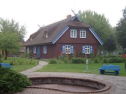
สีของบ้านเรือนทั่วไปสืบทอดมาจากศาสนาโบราณและเป็นสัญลักษณ์ของเทพเจ้าต่างๆ ได้แก่ ดิน (สีน้ำตาล) ท้องฟ้าและน้ำ (สีฟ้า) เมฆและละอองน้ำ (สีขาว) และด้านบนสุดประดับด้วย "žirgeliai" (หัวม้า) สองหัวไขว้กัน
จากการสำรวจสำมะโนประชากรในปี 1897 พบว่าประมาณ 60% ใช้ภาษาคูโรเนียน และบนเรือมีถึง 65% ในปี 1923 เมื่อลิทัวเนีย ได้อำนาจอธิปไตยเหนือแหลมแห่ง นี้ ชาวบ้านประสบปัญหาเรื่องสัญชาติ มีเพียงไม่กี่คนที่เลือกสัญชาติลิทัวเนีย หลายคนอพยพไปเยอรมนี และบางส่วนก็ยังคงอยู่ในหมู่บ้านในฐานะ "ชาวต่างชาติที่อาศัยอยู่ในเยอรมนี" ผลจากการสำรวจสำมะโนประชากรในปี 1956 พบว่า 59% เป็นชาวลิทัวเนีย 21% เป็นชาวรัสเซีย และมีเพียง 15% (22 ครอบครัว) เท่านั้นที่เป็นชาวพื้นเมือง
ตราแผ่นดิน
ตราประจำเมืองจากปี 1968 แสดงสัญลักษณ์สีดำและสีขาวของภูมิภาค Klaipėda , Kurenwimpel , Nida , Preila , Pervalka , JuodkrantėและPurvinėโดยตัวอักษร N หมายถึงชื่อใหม่
วรรณกรรม
- อารูเน อาร์บูชาอัสไก. Einige Aspekte der nationalen Selbsteinschätzung bei der altansässigen Bevölkerung der Kurischen Nehrung nach 1945, ใน Annaberger Annalen 1994 (ภาษาเยอรมัน)
ลิงก์ภายนอก


- de:Kurenwimpel (in German)
- อันนาเบอร์เกอร์ อันนาเลน(เยอรมัน)
- Neringa บน Litauen Netz (ในภาษาเยอรมัน)
- Neringa.tel - แอปพลิเคชันบนมือถือที่มีข้อมูลพื้นฐานเกี่ยวกับเมืองเนริงกา(เป็นภาษาอังกฤษ)
- NeringaTour - คู่มือท่องเที่ยวเมืองเนริงกาแบบเสมือนจริง(ภาษาอังกฤษ)
- NeringaTours - ทัวร์ แท็กซี่ รถตุ๊กตุ๊กใน Neringa (เป็นภาษาอังกฤษ)
- Captain Taxi - บริการแท็กซี่ในเนริงกา(ภาษาอังกฤษ)