
North Toraja Regency
North Toraja Regency Kabupaten Toraja Utara | |
|---|---|
 Tongkonan house in North Toraja | |
 Coat of arms | |
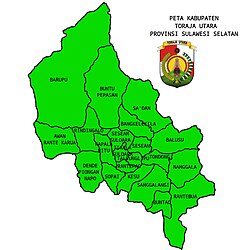 Location of districts within North Toraja Regency | |
| Country | Indonesia |
| Province | South Sulawesi |
| Capital | Rantepao |
| Government | |
| • Regent | Frederik Victor Palimbong |
| • Vice Regent | Andrew Branch Silambi |
| Area | |
• Total | 1,151.47 km2 (444.59 sq mi) |
| Population (mid 2025 estimate)[1] | |
• Total | 268,717 |
| • Density | 233.369/km2 (604.422/sq mi) |
| Time zone | UTC+7 (WIB) |
North Toraja (or Toraja Utara) is a landlocked regency (kabupaten) of South Sulawesi Province of Indonesia, and the home of the Toraja ethnic group. The local government seat is in Rantepao which is also the center of Toraja culture. Formerly this regency was the northeastern part of the existing Tana Toraja Regency, but on 24 June 2008 this northeastern 36% of the area was split off to form this separate North Toraja Regency. It covers an area of 1,151.47 km2 and had a population of 216,762 at the 2010 census[2] and 261,086 at the 2020 census;[3] the official estimate as at mid 2025 was 268,717 (comprising 137,047 males and 131,670 females).[1]
The Tana Toraja boundary was determined by the Dutch East Indies government in 1909. In 1926, Tana Toraja was under the administration of Bugis state of Luwu. The regentschap (or regency) status was given on 8 October 1946, the last regency given by the Dutch. Since 1984, Tana Toraja has been named as the second tourist destination after Bali by the Ministry of Tourism, Indonesia. Since then, hundreds of thousands of foreign visitors have visited this regency. In addition, numerous Western anthropologists have come to Tana Toraja to study the indigenous Torajan people and their culture.

Geography
ตานาโตราจาตั้งอยู่บนเกาะสุลาเวซี ห่างจาก มากัสซาร์เมืองหลวงของจังหวัดสุลาเวซีใต้ ไปทางเหนือ 300 กิโลเมตร ตำแหน่งทางภูมิศาสตร์อยู่ระหว่างละติจูด 2°-3° ใต้ และลองจิจูด 119°-120° ตะวันออก (จุดศูนย์กลาง: 3°S 120°E / 3°S 120°E / -3; 120 ) พื้นที่ของอำเภอโตราจาเหนือมีขนาด 1,151.47 ตารางกิโลเมตรคิดเป็นประมาณ 2.54% ของพื้นที่ทั้งหมดของจังหวัดสุลาเวซีใต้ ภูมิประเทศของตานาโตราจาเป็นภูเขา ระดับความสูงต่ำสุดอยู่ที่ 150 เมตร และสูงสุดอยู่ที่ 3,083 เมตรเหนือระดับน้ำทะเล[ 4 ]
เขตการปกครอง
อำเภอโตราจาเหนือประกอบด้วย เขตการปกครอง 21 แห่ง( Kecamatan ) ซึ่งแสดงไว้ในตารางด้านล่างพร้อมพื้นที่[ 1 ]และจำนวนประชากรตามสำมะโนประชากรปี 2010 [ 2 ]และสำมะโนประชากรปี 2020 [ 3 ]รวมทั้งประมาณการอย่างเป็นทางการ ณ กลางปี 2025 [ 1 ]ตารางนี้ยังรวมถึงที่ตั้งของศูนย์บริหารเขต จำนวนหมู่บ้านในแต่ละเขต (รวมทั้งหมด 110 หมู่บ้านในชนบท - เดิมเรียกว่าdesaปัจจุบันเรียกว่าlembang - และ 40 หมู่บ้านหรือเมืองในเมือง เรียกว่าkelurahan ) และรหัสไปรษณีย์
| โคเด วิลายาห์ | ชื่ออำเภอ( เกจาตาน ) | พื้นที่ใน หน่วย ตารางกิโลเมตร | สำมะโนประชากรปี2010 | สำมะโนประชากรPop'n ปี 2020 | Pop'n คาดการณ์กลางปี 2025 | ศูนย์บริหาร | จำนวนหมู่บ้าน | รหัสไปรษณีย์ |
|---|---|---|---|---|---|---|---|---|
| 73.26.08 | โสภา | 47.64 | 13,042 | 15,687 | 16,623 | โนนงันใต้ | 8 (ก) | 91850 |
| 73.26.15 | เคซู | 26.00 | 15,504 | 19,150 | 20,137 | บาตัน | 7 (ข) | 91852 |
| 73.26.17 | ซังกาลางิ | 39.00 | 11,129 | 13,218 | 14,125 | บุนตู ลาโบ | 6 (ค) | 91851 |
| 73.26.05 | บุนเทา | 49.50 | 8,911 | 11,443 | 11,456 | มิซา บาบานา | 6 (ง) | 91841 |
| 73.26.18 | รันเตบัว | 84.84 | 7,595 | 8,989 | 9,038 | บวงอิน | 7 (e) | 91842 |
| 73.26.03 | นังกาลา | 68.00 | 9,192 | 10,376 | 10,357 | นังกะห์ ซังเปียก ซาลู | 9 (ฉ) | 91856 |
| 73.26.16 | ตองดง | 36.00 | 9,465 | 12,529 | 12,332 | ตองดอน ลังกิ | 4 | 91857 |
| 73.26.11 | ทัลลุงลิปู | 9.42 | 18,068 | 20,644 | 20,681 | ทัลลุงลิปู | 7 (ก) | 91832 |
| 73.26.01 | รันเตเปา | 10.29 | 25,585 | 28,451 | 29,063 | ซิงกิ | 11 (ชม.) | 91835 (i) |
| 73.26.09 | ทิกาล่า | 23.44 | 10,275 | 12,342 | 13,012 | บุนตู บารานา | 7 (จ) | 91833 |
| 73.26.02 | เซเซียน | 40.05 | 10,893 | 13,319 | 13,599 | ปังลี่ | 9 (ก) | 91844 |
| 73.26.10 | บาลูซู | 46.51 | 6,760 | 7,983 | 8,459 | บาลูซู | 7 (ม.) | 91855 |
| 73.26.06 | ซาอ์ดัน | 80.49 | 14,923 | 18,722 | 19,633 | สัตลัน มาลิมบอง | 10 (น) | 91843 |
| 73.26.17 | บังเกเลกิลา | 21.00 | 5,128 | 8,525 | 8,110 | แทมปัน บองกา | 4 | 91853 |
| 73.26.19 | เซเซียน ซูโลอารา | 21.68 | 6,236 | 6,943 | 7,340 | ซูโลอารา | 5 | 91845 |
| 73.26.20 | กาปาลา ปิตู | 47.27 | 6,041 | 6,982 | 7,479 | โปโล ปาดัง | 6 | 91848 |
| 73.26.12 | Dende' Piongan Napo | 77.49 | 7,979 | 9,046 | 9,333 | เดนเด | 8 (หน้า) | 91822 |
| 73.26.21 | อาวัน รันเต การัว | 54.71 | 5,195 | 5,634 | 6,080 | อาวัน | 4 | 91854 |
| 73.26.04 | รินดิงกัลโล | 74.25 | 7,255 | 9,070 | 9,490 | ปังกาล่า | 9 (ร) | 91849 |
| 73.26.13 | บุนตู เปปาซัน | 131.72 | 12,228 | 14,582 | 15,015 | สะพัน | 13 (วินาที) | 91847 |
| 73.26.14 | บารุปปุ | 162.17 | 5,358 | 7,451 | 7,355 | บารุปปู เซลาตัน | 4 (ต) | 91846 |
| ยอดรวม | 1,151.47 | 216,762 | 261,086 | 268,717 | รันเตเปา | 150 |
หมายเหตุ: (a) รวมถึงkelurahanของ Nonangan Utara (ข) รวมทั้ง 2 เกลูราฮันของบาตันและปันตะนากัน โลโล(c) รวมถึงkelurahanของ Paepalean (ง) รวมทั้ง 2 kelurahanของ Tongkonan Bassae และ Tullang' Sura (จ) รวมทั้ง 2 kelurahanของ Bokin และ Buangin ด้วย (ฉ) รวมทั้งเกลูราฮันของนังคลาสันเปียกสลู ด้วย (g) ประกอบด้วย 6 kelurahanได้แก่ Rantepaku Tallunglipu, Tagari Tallunglipu, Tallunglipu, Tallunglipu Matalo, Tampo Tallunglipu และ Tantanan Tallunglipu และอีก 1 desa (Buntu Tallunglipu) (ซ) ประกอบด้วย 9 เกลูราฮานได้แก่ คาราสสิก, ลัง ตันดุก, มาลังโก', เมนติโรติกู, ปาซาเล, เปนาเนียน, รันเต ปาเซเล, รันเตเปา และซิงกี' และอีก 2 เดซา(i) ยกเว้นkelurahanของ Rantepao, Malangngo' และ Pasale (ซึ่งมีรหัสไปรษณีย์ร่วมกัน 91831) และ Mentirotiku และ Laang Tanduk (ซึ่งมีรหัสไปรษณีย์ร่วมกัน 91834) (ญ) รวมทั้ง 2 เกลูราฮันของบุนตู ปริณา และติกาลา (ฏ) ประกอบด้วย 5 เกลูราฮันของโบรี เดรี ปาลาวา ปังลี และปังคลีเซลาตัน บวกด้วย 4 เดซา(m) รวมทั้ง 2 kelurahanของ Balusu และ Tagari (n) รวมทั้ง 2 kelurahanของ Sa'dan Malimbong และ Sa'dan Matallo. (ณ) รวมทั้งเกลูราฮานแห่งปาสัง ด้วย (ต) รวมทั้ง 2 เกลูราฮันของปังคลา' และปังคลา' อุตารา(s) รวมถึงเกลูราฮันของซาปาน ด้วย (t) รวมถึงkelurahanของ Baruppu Selatan
ดูเพิ่มเติม

ลิงก์ภายนอก

- Toraja Treasures.com - ข้อมูลออนไลน์ของ Toraja
- เว็บไซต์อย่างเป็นทางการ