
พรอคเตอร์ มินนิโซตา
โปรคเตอร์ | |
|---|---|
| เมืองโปรคเตอร์ | |
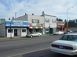 ย่านใจกลางเมืองพรอคเตอร์ ริมทางหลวงหมายเลข 2 ของสหรัฐอเมริกา | |
| ภาษิต: คุณมีที่ใน Proctor | |
 ที่ตั้งของเมืองพรอคเตอร์ภายในเขตเซนต์หลุยส์เคาน์ตี้ รัฐมินนิโซตา | |
| พิกัด: 46°44′36″N 92°13′32″W / 46.74333°N 92.22556°W / 46.74333; -92.22556 | |
| ประเทศ | สหรัฐอเมริกา |
| สถานะ | มินนิโซตา |
| เขต | เซนต์หลุยส์ |
| พื้นที่ | |
• ทั้งหมด | 3.36 ตาราง ไมล์ (8.71 ตาราง กิโลเมตร) |
| • ที่ดิน | 3.36 ตาราง ไมล์ (8.71 ตาราง กิโลเมตร) |
| • น้ำ | 0 ตาราง ไมล์ (0.00 ตาราง กิโลเมตร) |
| ระดับความสูง | 1,247 ฟุต (380 เมตร) |
| ประชากร ( 2020 ) | |
• ทั้งหมด | 3,120 |
| • ความหนาแน่น | 928.2/ตร. ไมล์ (358.39/ ตร.กม. ) |
| เขตเวลา | เวลา 6.00 น. ตามเวลา ภาคกลาง ( CST ) |
| • ฤดูร้อน ( เวลาออมแสง ) | 5 โมงเช้า (CDT) |
| รหัสไปรษณีย์ | 55810 |
| รหัสพื้นที่ | 218 |
| รหัส FIPS | 27-52630 [ 3 ] |
| รหัสคุณลักษณะGNIS | 0662232 [ 2 ] |
| เว็บไซต์ | https://proctormn.gov/ |
Proctorเป็นเมืองใน เทศ มณฑลเซนต์หลุยส์รัฐมินนิโซตาสหรัฐอเมริกา ก่อตั้งขึ้นในปี 1894 เมืองนี้ได้รับการตั้งชื่อตามอดีตผู้ ว่าการรัฐเคน ตักกี้J. Proctor Knottเป็นส่วนหนึ่งของเขตมหานครดูลูธมีประชากร 3,120 คนตาม สำมะโนประชากร ปี2020 [ 4 ]
ประวัติศาสตร์
เมืองนี้ก่อตั้งขึ้นในชื่อProctorknottในปี 1894 โดยชื่อนี้มาจากอดีตผู้ว่าการรัฐเคนตักกี้J. Proctor Knottซึ่งมีชื่อเสียงจากการกล่าวสุนทรพจน์เรื่องThe Untold Delights of Duluthต่อสภาผู้แทนราษฎรของสหรัฐอเมริกาชื่อเมืองถูกย่อให้เหลือเพียง Proctor ในปี 1904 [ 5 ]
ภูมิศาสตร์
ตามข้อมูลจากสำนักงานสำมะโนประชากรของสหรัฐอเมริกาเมืองนี้มีพื้นที่3.00 ตารางไมล์ (7.77 ตารางกิโลเมตร) ซึ่ง เป็นพื้นที่ดินทั้งหมด[ 6 ]
Proctor is adjacent to Duluth's Bayview Heights neighborhood, with which it forms something of a contiguous community unit due to Bayview Heights's topographical separation (the hill) from adjacent West Duluth. It is bounded by the city of Hermantown to the north, Midway Township to the west, Bayview Heights to the east, and a mostly undeveloped area of Duluth (officially in the Riverside neighborhood) to the south.
Kingsbury Creek flows through central Proctor. Knowlton Creek flows through southeast Proctor.
Demographics
| Census | Pop. | Note | %± |
|---|---|---|---|
| 1900 | 784 | — | |
| 1910 | 2,243 | 186.1% | |
| 1920 | 2,378 | 6.0% | |
| 1930 | 2,521 | 6.0% | |
| 1940 | 2,468 | −2.1% | |
| 1950 | 2,693 | 9.1% | |
| 1960 | 2,963 | 10.0% | |
| 1970 | 3,123 | 5.4% | |
| 1980 | 3,180 | 1.8% | |
| 1990 | 2,974 | −6.5% | |
| 2000 | 2,852 | −4.1% | |
| 2010 | 3,057 | 7.2% | |
| 2020 | 3,120 | 2.1% | |
| U.S. Decennial Census | |||
2020 census
As of the 2020 census, Proctor had a population of 3,120. The median age was 41.4 years. 22.1% of residents were under the age of 18 and 20.1% of residents were 65 years of age or older. For every 100 females there were 102.3 males, and for every 100 females age 18 and over there were 97.4 males age 18 and over.[7][8]
98.1% of residents lived in urban areas, while 1.9% lived in rural areas.[9]
There were 1,313 households in Proctor, of which 27.0% had children under the age of 18 living in them. Of all households, 47.1% were married-couple households, 19.6% were households with a male householder and no spouse or partner present, and 24.9% were households with a female householder and no spouse or partner present. About 32.8% of all households were made up of individuals and 12.8% had someone living alone who was 65 years of age or older.[7]
There were 1,373 housing units, of which 4.4% were vacant. The homeowner vacancy rate was 0.7% and the rental vacancy rate was 2.5%.[7]
| Race | Number | Percent |
|---|---|---|
| White | 2,867 | 91.9% |
| Black or African American | 15 | 0.5% |
| American Indian and Alaska Native | 33 | 1.1% |
| Asian | 29 | 0.9% |
| Native Hawaiian and Other Pacific Islander | 0 | 0.0% |
| Some other race | 18 | 0.6% |
| Two or more races | 158 | 5.1% |
| Hispanic or Latino (of any race) | 49 | 1.6% |
2010 census
As of the census[10] of 2010, there were 3,057 people, 1,268 households, and 795 families living in the city. The population density was 1,019.0 inhabitants per square mile (393.4/km2). There were 1,361 housing units at an average density of 453.7 per square mile (175.2/km2). The racial makeup of the city was 96.8% White, 0.2% African American, 1.1% Native American, 0.4% Asian, 0.2% from other races, and 1.3% from two or more races. Hispanic or Latino of any race were 1.2% of the population.
There were 1,268 households, of which 27.4% had children under the age of 18 living with them, 48.8% were married couples living together, 9.6% had a female householder with no husband present, 4.3% had a male householder with no wife present, and 37.3% were non-families. 30.4% of all households were made up of individuals, and 13% had someone living alone who was 65 years of age or older. The average household size was 2.34 and the average family size was 2.90.
The median age in the city was 41.4 years. 20.7% of residents were under the age of 18; 8.2% were between the ages of 18 and 24; 25.5% were from 25 to 44; 29.7% were from 45 to 64; and 16.1% were 65 years of age or older. The gender makeup of the city was 49.3% male and 50.7% female.
2000 census
As of the census of 2000,[3] there were 2,852 people, 1,196 households, and 772 families living in the city. The population density was 942.8 inhabitants per square mile (364.0/km2). There were 1,246 housing units at an average density of 411.9 per square mile (159.0/km2). The racial makeup of the city was 96.49% White, 0.14% African American, 1.16% Native American, 0.53% Asian, 0.28% from other races, and 1.40% from two or more races. Hispanic or Latino of any race were 0.74% of the population. 19.8% were of German, 17.9% Norwegian, 10.3% Swedish, 7.3% French, 7.0% Finnish, 6.2% Polish, 6.0% Irish and 5.4% Italian ancestry.
There were 1,196 households, out of which 28.6% had children under the age of 18 living with them, 51.5% were married couples living together, 10.6% had a female householder with no husband present, and 35.4% were non-families. 30.8% of all households were made up of individuals, and 17.1% had someone living alone who was 65 years of age or older. The average household size was 2.38 and the average family size was 2.99.
In the city, the population was spread out, with 24.0% under the age of 18, 9.4% from 18 to 24, 27.3% from 25 to 44, 23.6% from 45 to 64, and 15.8% who were 65 years of age or older. The median age was 38 years. For every 100 females, there were 86.6 males. For every 100 females age 18 and over, there were 85.8 males.
The median income for a household in the city was $38,322, and the median income for a family was $49,875. Males had a median income of $33,583 versus $22,035 for females. The per capita income for the city was $18,851. About 3.2% of families and 5.0% of the population were below the poverty line, including 5.5% of those under age 18 and 5.9% of those age 65 or over.
Politics
| Year | Republican | Democratic | Third parties |
|---|---|---|---|
| 2020 | 40.6% 790 | 56.8%1,106 | 2.6% 51 |
| 2016 | 37.8% 655 | 52.2%903 | 10.0% 173 |
| 2012 | 29.8% 525 | 67.6%1,193 | 2.6% 46 |
| 2008 | 29.9% 546 | 67.6%1,234 | 2.5% 46 |
| 2004 | 29.0% 511 | 69.9%1,233 | 1.1% 20 |
| 2000 | 28.2% 443 | 66.2%1,042 | 5.6% 88 |
| 1996 | 22.5% 348 | 66.6%965 | 9.9% 147 |
| 1992 | 19.8% 327 | 61.8%1,019 | 18.4% 304 |
| 1988 | 27.0% 392 | 73.0%1,062 | 0.0% 0 |
| 1984 | 25.1% 394 | 74.9%1,178 | 0.0% 0 |
| 1980 | 22.9% 376 | 71.9%1,179 | 5.2% 85 |
| 1976 | 24.7% 372 | 73.4%1,106 | 1.9% 26 |
| 1968 | 14.3% 195 | 83.3%1,133 | 2.4% 33 |
| 1964 | 14.8% 213 | 85.1%1,224 | 0.1% 2 |
| 1960 | 31.1% 442 | 68.7%977 | 0.2% 4 |
Culture
เมืองพรอคเตอร์เป็นที่ตั้งของสนามจัดงานแสดงสินค้าประจำเทศมณฑลเซาท์เซนต์หลุยส์ และสนามแข่งรถพรอคเตอร์สปีดเวย์
เทศกาล Proctor Hoghead จัดขึ้นทุกเดือนสิงหาคม เทศกาล Hoghead เป็นการเฉลิมฉลองประวัติศาสตร์ทางรถไฟของเมือง Proctor
พิพิธภัณฑ์พื้นที่พรอคเตอร์อยู่ภายใต้การบริหารงานของสมาคมประวัติศาสตร์พื้นที่พรอคเตอร์
เมืองพรอคเตอร์เป็นจุดเริ่มต้นของ Blackwoods Blizzard Tour ซึ่งเป็นการขับขี่รถสโนว์โมบิลประจำปีรอบทางตอนเหนือของรัฐมินนิโซตา เพื่อระดมทุนต่อสู้กับโรค ALSเส้นทางการขับขี่เริ่มต้นจากพรอคเตอร์ไปยังทาวเวอร์ต่อไปยังทูฮาร์เบอร์สและกลับมายังพรอคเตอร์ องค์กรนี้ระดมทุนได้มากกว่า 1 ล้านดอลลาร์สหรัฐทุกปีเพื่อการวิจัยโรค ALS ทำให้เป็นกิจกรรมระดมทุนด้วยรถสโนว์โมบิลที่ใหญ่ที่สุดในโลก
โครงสร้างพื้นฐาน
ระบบขนส่งสาธารณะ
ทางหลวงสายหลัก


การศึกษา
เขตการศึกษาของ Proctor คือ Proctor Public Schools ซึ่งครอบคลุมพื้นที่ Proctor, ย่าน Bayview HeightsในDuluthและ ตำบล Canosia , Grand Lake , MidwayและSolway ISD 704 ดำเนินการโรงเรียนประถมศึกษา 2 แห่ง (Bayview Heights และ Pike Lake), โรงเรียนมัธยมต้น Jedlicka และโรงเรียนมัธยมปลาย Proctor
External links
- City of Proctor, MN – Official site
- Proctor Schools site
- Proctor Journal newspaper site
- Proctor Area Chamber of Commerce website
- Official Proctor, MN Travel Guide site
46°44′50″N92°13′32″W / 46.74722°N 92.22556°W / 46.74722; -92.22556