
Quebec Route 251
 Route 251 | ||||
|---|---|---|---|---|
 | ||||
| Route information | ||||
| Maintained by Transports Québec | ||||
| Length | 38.5 km[1] (23.9 mi) | |||
| Major junctions | ||||
| South end |  R-141 in Saint-Herménégilde R-141 in Saint-Herménégilde | |||
| Major intersections |  R-206 in Sainte-Edwidge-de-Clifton R-206 in Sainte-Edwidge-de-Clifton  R-208 in Martinville R-208 in Martinville | |||
| North end |  R-108 in Cookshire-Eaton R-108 in Cookshire-Eaton | |||
| Location | ||||
| Country | Canada | |||
| Province | Quebec | |||
| Major cities | Martinville | |||
| Highway system | ||||
| ||||


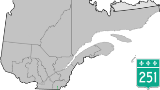
Route 251 is a north–south highway on the south shore of the St. Lawrence River. Its northern terminus is at Route 108 in Cookshire-Eaton, and its southern terminus is at Route 141, in Saint-Herménégilde.
Municipalities along Route 251
 Junction of Route 208 with Route 251 in Martinville.
 Bridge over Saumons River.
See also
External links
- Route 251 on Google Maps
- Provincial Route Map (Courtesy of the Quebec Ministry of Transportation)Archived 2008-05-17 at the Wayback Machine(in French)
 | This Quebec road, road transport or highway-related article is a stub. You can help Wikipedia by adding missing information. |