อ่าน 3 นาที
Ralsko
Ralsko ( German : Roll ) is a town in Česká Lípa District in the Liberec Region of the Czech Republic . It has about 2,200 inhabitants.
Ralsko
Ralsko | |
|---|---|
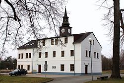 Town hall | |
 Flag  Coat of arms | |
 Ralsko Location in the Czech Republic | |
| Coordinates: 50°36′45″N14°47′27″E / 50.61250°N 14.79083°E | |
| Country | |
| Region | Liberec |
| District | Česká Lípa |
| First mentioned | 1279 |
| Government | |
| • Mayor | Miloslav Tůma |
| Area | |
• Total | 170.23 km2 (65.73 sq mi) |
| Elevation | 331 m (1,086 ft) |
| Population (2025-01-01)[1] | |
• Total | 2,220 |
| • Density | 13.0/km2 (33.8/sq mi) |
| Time zone | UTC+1 (CET) |
| • Summer (DST) | UTC+2 (CEST) |
| Postal codes | 295 01, 463 52, 471 24 |
| Website | mestoralsko |
Ralsko (German: Roll) is a town in Česká Lípa District in the Liberec Region of the Czech Republic. It has about 2,200 inhabitants. It comprises area of the former military training area with Hradčany Air Base. Ralsko is the fourth largest municipality in the country by area.
Administrative division
Ralsko consists of nine municipal parts (in brackets population according to the 2021 census):[2]
- Boreček (65)
- Horní Krupá (41)
- Hradčany (156)
- Hvězdov (140)
- Jabloneček (0)
- Kuřívody (606)
- Náhlov (107)
- Ploužnice (955)
- Svébořice (17)
The town hall is located in Kuřívody.
Etymology
The town is named after the mountain Ralsko. The mountain was initially named Radlsko, meaning "belonging to a place called Rádlo".[3]
Geography
Ralsko is located about 21 km (13 mi) southeast of Česká Lípa and 25 km (16 mi) southwest of Liberec. It lies in the Ralsko Uplands. The highest point of Ralsko and the entire Ralsko Uplands in the Ralsko mountain at 696 m (2,283 ft) above sea level, located on the northern municipal border. The Ploučnice River shortly crosses the municipal territory in the northeast. There are several fishonds in the area; the largest of them are Hradčanský and Novodvorský.
Because of the former military area, the town's municipal territory is 170.23 km2 (65.73 sq mi), which makes it the fourth largest municipality in the country after the cities of Prague, Brno and Ostrava.
History
ส่วนที่เก่าแก่ที่สุดของ Ralsko คือ Kuřívody การกล่าวถึง Kuřívody เป็นลายลักษณ์อักษรครั้งแรกมาจากปี 1279 โดยก่อตั้งขึ้นระหว่างปี 1264 ถึง 1278 โดยOttokar II แห่งโบฮีเมียในฐานะเมืองหลวง เนื่องจากขาดแคลนน้ำ จึงยังคงเป็นเมืองเล็กๆ ตลอดมา[ 4 ]
ก่อนปี 1945 มีประชากรมากกว่า 7,000 คนในพื้นที่ราลสโกในปัจจุบัน ในช่วงต้นปี 1945 กองทัพเยอรมันได้สร้างฐานทัพอากาศฮราดชานี ขึ้น หลังจาก สงครามโลกครั้งที่สองชาวเยอรมันส่วนใหญ่ถูกขับไล่ออกไป[ 4 ]
ในปี พ.ศ. 2493 ได้มีการจัดตั้ง พื้นที่ฝึกอบรมทางทหารราลสโกขึ้น ในปี พ.ศ. 2535 ได้มีการยกเลิกพื้นที่ดังกล่าวและจัดตั้งเทศบาลเมืองราลสโกขึ้น ในปี พ.ศ. 2549 ราลสโกได้กลายเป็นเมือง[ 4 ]
พื้นที่ฝึกซ้อมทางทหารราลสโก
ระหว่างปี พ.ศ. 2489 ถึง พ.ศ. 2493 ชาวบ้านถูกย้ายถิ่นฐานเพื่อจัดตั้งพื้นที่ฝึกซ้อมทางทหารในบริเวณรอบๆ ภูเขาราลสโก การอพยพของประชากรเสร็จสิ้นในวันที่ 31 ตุลาคม พ.ศ. 2495 ชาวบ้านกว่า 3,000 คนถูกขับไล่ออกจากหมู่บ้าน[ 4 ]
ภูเขาราลสโกและสนามบินถูกใช้เป็นพื้นที่ทดสอบอาวุธทางทหารมานานหลายทศวรรษ หลังเหตุการณ์ปรากสปริงในปี 1968 สถานที่แห่งนี้ก็ถูกประจำการโดยกองทหารโซเวียต ในช่วงปลายทศวรรษ 1980 กองพลขีปนาวุธที่ 442 ของโซเวียต ได้ ประจำการขีปนาวุธทางยุทธวิธีระยะสั้น SS-21ที่ฮเวซดอฟ ในปี 1988 มีชาวโซเวียต (ทหารและครอบครัว) อาศัยอยู่ถาวรในพื้นที่มากกว่า 20,000 คน หลังจากสหภาพโซเวียตล่มสลายในปี 1990-1991 ขีปนาวุธก็ถูกถอนออกและพื้นที่ทดสอบอาวุธทั้งหมดก็ถูกปิดล้อม
ข้อมูลประชากร
ประชากรในอดีต | ||||||||||||||||||||||||||||||||||||||||||||||||||||||||
|
|
| ||||||||||||||||||||||||||||||||||||||||||||||||||||||
| แหล่งที่มา: สำมะโนประชากร[ 5 ] [ 6 ] | ||||||||||||||||||||||||||||||||||||||||||||||||||||||||
ขนส่ง
แม้จะมีพื้นที่กว้างขวาง แต่ก็ไม่มีทางรถไฟหรือถนนสายหลักตัดผ่านเขตเทศบาล
สถานที่ท่องเที่ยว

กระสุนที่ถูกทิ้งของเช็กและโซเวียตจำนวนมากถูกรวบรวมและจัดแสดงอยู่ที่พิพิธภัณฑ์เล็กๆ ใน Kuřívody [ 7 ]เมื่อไม่นานมานี้ พื้นที่ฝึกซ้อมทางทหารเดิมได้ถูกเปิดเป็นเขตอนุรักษ์ธรรมชาติ บนภูเขา Ralsko มีซากปรักหักพังของปราสาทโกธิก ซึ่งถูกทิ้งร้างมาตั้งแต่ศตวรรษที่ 16 [ 8 ]
มีปราสาทสมัยเรเนสซองส์อยู่ที่เมืองคูรีโวดี ซึ่งเดิมเป็นป้อมปราการ[ 4 ]
ลิงก์ภายนอก
- เว็บไซต์อย่างเป็นทางการ
สรุปเนื้อหา
ข้อมูลสำคัญจากบทความ
ข้อมูลสำคัญเกี่ยวกับ Ralsko
Ralsko ( German : Roll ) is a town in Česká Lípa District in the Liberec Region of the Czech Republic . It has about 2,200 inhabitants.
Administrative division
Ralsko consists of nine municipal parts (in brackets population according to the 2021 census): [ 2 ]
Etymology
The town is named after the mountain Ralsko . The mountain was initially named Radlsko, meaning "belonging to a place called Rádlo". [ 3 ]
Geography
Ralsko is located about 21 km (13 mi) southeast of Česká Lípa and 25 km (16 mi) southwest of Liberec . It lies in the Ralsko Uplands .