
Rambler Channel
| Rambler Channel | |||||||||||||||
|---|---|---|---|---|---|---|---|---|---|---|---|---|---|---|---|
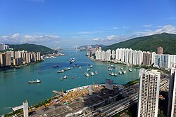 Over Rambler Channel in August 2014 | |||||||||||||||
| Traditional Chinese | 藍巴勒海峽 | ||||||||||||||
| Simplified Chinese | 蓝巴勒海峡 | ||||||||||||||
| |||||||||||||||

Rambler Channel is a body of water in Hong Kong that separates Tsing Yi Island from Tsuen Wan and Kwai Chung in the New Territories. The channel separates the two landmasses by 900 metres at its widest point.
Historically, the channel was known as Tsing Yi Mun (青衣門) and Tsing Yi Channel (青衣海峽). The current name of the channel likely originates from HMS Rambler, one of the naval survey ships which charted the waters of this area.
The shoreline of the channel has changed rapidly in the last several decades, owing to the development of Tsuen Wan New Town and the Kwai Chung Container Port. Before extensive reclamation, Gin Drinkers Bay was located along the eastern shore of the channel, and Tsing Yi Bay was located along the western shore. Three islands (Nga Ying Chau, Pillar Island and Mong Chau) once stood in the channel as well.
Port facilities
Transport
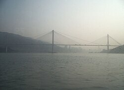
Six road bridges and one rail bridge span the channel:
- Ting Kau Bridge, connecting Tsing Yi Island with Tuen Mun Road and Tai Lam Tunnel
- Tsing Tsuen Bridge, usually known as the Tsing Yi North Bridge
- Tsing Lai Bridge, the sole railway bridge, used by the MTRmetro system
- สะพานเชียงชิงซึ่งเป็นส่วนหนึ่งของทางหลวงชิงไคว่ ( เส้นทางหมายเลข 3 ) ที่มุ่งหน้าไปยังอุโมงค์เชียงชิง
- สะพานชิงอี้หรือที่รู้จักกันทั่วไปในชื่อสะพานชิงอี้ใต้
- สะพานไคว่ชิงหรือที่รู้จักกันทั่วไปในชื่อสะพานชิงอี้ใต้แห่งที่สอง
- สะพานสโตนคัตเตอร์เชื่อมเกาะชิงยีกับเกาะสโตนคัตเตอร์
ท่าเรือข้ามฟาก
- ท่าเรือเฟอร์รี่เชินวัน (ถูกรื้อถอนเพื่อสร้างสถานีรถไฟเชินวันตะวันตก )
- ท่าเรือเฟอร์รี่ชิงยี่ (บริการเรือข้ามฟากไปยังท่าเรือนี้ได้หยุดให้บริการแล้ว)
ดูเพิ่มเติม
ลิงก์ภายนอก

- "ช่องแรมเบลอร์"สำนักงานบริการภาพยนตร์ เก็บถาวรจากต้นฉบับเมื่อวันที่ 27 กันยายน 2550 เรียกดูเมื่อวันที่ 29 มีนาคม 2550
22°21′56″N 114°5′59″E / 22.36556°N 114.09972°E / 22.36556; 114.09972
 | บทความเกี่ยวกับสถานที่ในฮ่องกงนี้ ยัง ไม่สมบูรณ์คุณสามารถช่วยวิกิพีเดียได้โดยการเพิ่มข้อมูลที่ขาดหายไป |