
Sim Smith Covered Bridge
Coordinates: 39°46′24.75″N87°19′52.20″W / 39.7735417°N 87.3311667°W / 39.7735417; -87.3311667
Sims Smith Covered Bridge | |
|---|---|
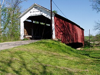 North Portal | |
| Coordinates | 39°46′24.75″N87°19′52.20″W / 39.7735417°N 87.3311667°W / 39.7735417; -87.3311667 |
| Carries | C.R. W40N |
| Crosses | Leatherwood Creek, Indiana |
| Locale | Parke County, Indiana, United States |
| Official name | Sims Smith Covered Bridge |
| Named for | Simeon Smith |
| Maintained by | Parke County |
| NBI Number | 6100060[1] |
| Characteristics | |
| Design | National Register of Historic Places |
| Total length | 102 ft (31 m)84ft +9ft overhangs on each end |
| Width | 16 ft (4.9 m) |
| Height | 14 ft (4.3 m) |
| History | |
| Constructed by | Britton, J.A. |
| Built | 1883 |
| Rebuilt | 1977 |
Sim Smith Covered Bridge | |
| MPS | Parke County Covered Bridges TR |
| NRHP reference No. | 78000411[2] |
| Added to NRHP | Dec 22, 1978 |
| Location | |
 Interactive map of Sims Smith Covered Bridge | |
The Sim Smith Covered Bridge is east of Montezuma, Indiana. The single span Burr Truss covered bridge structure was built by Joseph A. Britton in 1883. The bridge is 101 feet (31 m) long, 16 feet (4.9 m) wide, and 14 feet (4.3 m) high.[3][4]
It was added to the National Register of Historic Places in 1978.[2]
Gallery
 Detail of Burr Arch and King Posts
 Detail of Abutment
See also
ลิงก์ภายนอก
 สื่อที่เกี่ยวข้องกับสะพานไม้คลุมหลังคาซิม สมิธในวิกิมีเดียคอมมอนส์
 | บทความเกี่ยวกับสะพานแห่งหนึ่งในรัฐอินเดียนาชิ้นนี้ยังไม่สมบูรณ์คุณสามารถช่วยวิกิพีเดียได้โดยการเพิ่มข้อมูลที่ขาดหายไป |