
หัวสั่น


\", \"description\": \" ([https://geohack.toolforge.org/geohack.php?params=52.02583;-5.06291_dim:2000 52.02583,-5.06291])\", \"marker-symbol\": \"-number-F469596\", \"marker-size\": \"medium\", \"marker-color\": \"#DB3123\" }, \"geometry\": {\"type\": \"Point\", \"coordinates\": [-5.06291,52.02583] } }, { \"type\": \"Feature\", \"properties\": { \"title\": \"[[Strumble Head Lighthouse]]
\", \"description\": \" ([https://geohack.toolforge.org/geohack.php?params=52.02975;-5.07381_dim:2000 52.02975,-5.07381])\", \"marker-symbol\": \"-number-F469596\", \"marker-size\": \"medium\", \"marker-color\": \"#DB3123\" }, \"geometry\": {\"type\": \"Point\", \"coordinates\": [-5.07381,52.02975] } }, { \"type\": \"Feature\", \"properties\": { \"title\": \"Ynys Meicel
\", \"description\": \" ([https://geohack.toolforge.org/geohack.php?params=52.03004;-5.07381_dim:2000 52.03004,-5.07381])\", \"marker-symbol\": \"-number-F469596\", \"marker-size\": \"medium\", \"marker-color\": \"#DB3123\" }, \"geometry\": {\"type\": \"Point\", \"coordinates\": [-5.07381,52.03004] } }, { \"type\": \"Feature\", \"properties\": { \"title\": \"Ynys Onnen
\", \"description\": \" ([https://geohack.toolforge.org/geohack.php?params=52.0283;-5.0779_dim:2000 52.0283,-5.0779])\", \"marker-symbol\": \"-number-F469596\", \"marker-size\": \"medium\", \"marker-color\": \"#DB3123\" }, \"geometry\": {\"type\": \"Point\", \"coordinates\": [-5.0779,52.0283] } }, { \"type\": \"Feature\", \"properties\": { \"title\": \"Carreg Onnen
\", \"description\": \" ([https://geohack.toolforge.org/geohack.php?params=52.0283;-5.079_dim:2000 52.0283,-5.079])\", \"marker-symbol\": \"-number-F469596\", \"marker-size\": \"medium\", \"marker-color\": \"#DB3123\" }, \"geometry\": {\"type\": \"Point\", \"coordinates\": [-5.079,52.0283] } }, { \"type\": \"Feature\", \"properties\": { \"title\": \"Carreg Onnen Bay
\", \"description\": \" ([https://geohack.toolforge.org/geohack.php?params=52.027;-5.0759_dim:2000 52.027,-5.0759])\", \"marker-symbol\": \"-number-F469596\", \"marker-size\": \"medium\", \"marker-color\": \"#77A1CB\" }, \"geometry\": {\"type\": \"Point\", \"coordinates\": [-5.0759,52.027] } }, { \"type\": \"Feature\", \"properties\": { \"title\": \"Pwll Bach
\", \"description\": \" ([https://geohack.toolforge.org/geohack.php?params=52.0302;-5.0598_dim:2000 52.0302,-5.0598])\", \"marker-symbol\": \"-number-F469596\", \"marker-size\": \"medium\", \"marker-color\": \"#77A1CB\" }, \"geometry\": {\"type\": \"Point\", \"coordinates\": [-5.0598,52.0302] } }, { \"type\": \"Feature\", \"properties\": { \"title\": \"Pwlluog
\", \"description\": \" ([https://geohack.toolforge.org/geohack.php?params=52.0282;-5.0581_dim:2000 52.0282,-5.0581])\", \"marker-symbol\": \"-number-F469596\", \"marker-size\": \"medium\", \"marker-color\": \"#77A1CB\" }, \"geometry\": {\"type\": \"Point\", \"coordinates\": [-5.0581,52.0282] } }, { \"type\": \"Feature\", \"properties\": { \"title\": \"Porthsychan
\", \"description\": \" ([https://geohack.toolforge.org/geohack.php?params=52.0258;-5.0539_dim:2000 52.0258,-5.0539])\", \"marker-symbol\": \"-number-F469596\", \"marker-size\": \"medium\", \"marker-color\": \"#77A1CB\" }, \"geometry\": {\"type\": \"Point\", \"coordinates\": [-5.0539,52.0258] } }, { \"type\": \"Feature\", \"properties\": { \"title\": \"Strumble Head car park
\", \"description\": \" ([https://geohack.toolforge.org/geohack.php?params=52.0291;-5.0705_dim:2000 52.0291,-5.0705])\", \"marker-symbol\": \"-number-F469596\", \"marker-size\": \"medium\", \"marker-color\": \"#444433\" }, \"geometry\": {\"type\": \"Point\", \"coordinates\": [-5.0705,52.0291] } }, { \"type\": \"Feature\", \"properties\": { \"title\": \"lookout post - now a wildlife viewing shelter
\", \"description\": \" ([https://geohack.toolforge.org/geohack.php?params=52.03026;-5.06895_dim:2000 52.03026,-5.06895])\", \"marker-symbol\": \"-number-F469596\", \"marker-size\": \"medium\", \"marker-color\": \"#DB3123\" }, \"geometry\": {\"type\": \"Point\", \"coordinates\": [-5.06895,52.03026] } }, { \"type\": \"Feature\", \"properties\": { \"title\": \"Pwll yr Aren
\", \"description\": \" ([https://geohack.toolforge.org/geohack.php?params=52.0311;-5.0656_dim:2000 52.0311,-5.0656])\", \"marker-symbol\": \"-number-F469596\", \"marker-size\": \"medium\", \"marker-color\": \"#77A1CB\" }, \"geometry\": {\"type\": \"Point\", \"coordinates\": [-5.0656,52.0311] } }, { \"type\": \"Feature\", \"properties\": { \"title\": \"Calburga wreck site
\", \"description\": \" ([https://geohack.toolforge.org/geohack.php?params=52.01818;-5.09414_dim:2000 52.01818,-5.09414])\", \"marker-symbol\": \"-number-F469596\", \"marker-size\": \"medium\", \"marker-color\": \"#77A1CB\" }, \"geometry\": {\"type\": \"Point\", \"coordinates\": [-5.09414,52.01818] } } ] } ]"}}">
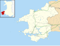
สตรัมเบิลเฮด ( ภาษาเวลส์: Pen Caer, Trwyn-câr, Pen Strwmbl ) เป็นแหลมหินในชุมชนเพนแคร์ใน เพมโบ รกเชียร์ประเทศเวลส์ซึ่งอยู่ในเขตอุทยานแห่งชาติชายฝั่งเพม โบรก เชียร์ เป็นจุดสิ้นสุดทางใต้ของอ่าวคาร์ดิ แกน มีเกาะสามเกาะตั้งอยู่ใกล้กับแหลม ได้แก่ เกาะอินิส เมเซล ( สูง 112 ฟุต หรือ 34 เมตร)เกาะอินิส ออนเนนและเกาะคาร์เรก ออนเนน
แหลม
Strumble Head ซึ่งอยู่บนเส้นทางเดินเลียบชายฝั่ง Pembrokeshireเป็นส่วนหนึ่งของพื้นที่คุ้มครองทางวิทยาศาสตร์พิเศษStrumble Head - Llechdafad Cliffs และเป็นหนึ่งในสถานที่ที่ดีที่สุดในสหราชอาณาจักรสำหรับการชมวาฬและ โลมา โดยเฉพาะโลมาปากสั้นซึ่งสามารถมองเห็นได้ในบริเวณน้ำขึ้นน้ำลงรอบแหลมด้วยกล้องส่องทางไกลธรรมดาๆSea Trustซึ่ง เป็น องค์กรอนุรักษ์สัตว์ทะเลในท้องถิ่นที่ตั้งอยู่ในGoodwick มักจัดกิจกรรมชมวาฬและโลมา [ 1 ]มักจะพบเห็นแมวน้ำ ได้ สถานที่ตั้งเครื่องส่งสัญญาณไมโครเวฟทดลองในช่วงสงคราม [ 2 ]ถูกดัดแปลงเป็นที่พักพิงสำหรับผู้ชื่นชอบสัตว์ป่าและเปิดโดยBill Oddieในปี 1988 [ 3 ]นอกจากสัตว์เลี้ยงลูกด้วยนมในทะเลแล้ว แหลมแห่งนี้ยังเป็นสถานที่ที่ดีเป็นพิเศษสำหรับการสังเกตการอพยพของนก โดยเฉพาะในช่วงปลายเดือนกรกฎาคมถึงเดือนพฤศจิกายน[ 4 ]
ชายฝั่งที่อยู่ติดกันนี้เคยเป็นที่ตั้งของเรืออับปางจำนวนมาก ในปี 2003 พบ ซากเรือ ฝรั่งเศสที่อาจมาจากยุทธการที่ฟิชการ์ด ในบริเวณใกล้เคียง [ 5 ] เรือบาร์ดเซออฟ เดอะไพล์ ออฟ ฟาวเดรย์อับปางนอกชายฝั่งสตรัมเบิลเฮดเมื่อวันที่ 3 ตุลาคม 1763 บรรทุกสินค้าเหล็กและทองแดงจากวิคโลว์มุ่งหน้าไปยังเชปสโตว์ [ 6 ] ในปี 1915 เรือบาร์ค คัลบูร์กาซึ่งเป็นหนึ่งใน เรือใบสี่เหลี่ยมลำสุดท้ายของ แคนาดาได้จมลง ลูกเรือสามารถขึ้นเรือชูชีพได้อย่างปลอดภัย ทำให้เกิดเศษซากกระจัดกระจายอยู่บริเวณชายฝั่ง ซึ่งยังคงอยู่ทางทิศตะวันตกเฉียงใต้ของประภาคาร 1 ไมล์ (1500 เมตร) [ 7 ]
แหลมนี้เป็นที่มาของชื่อประภาคาร Strumble HeadบนเกาะYnys Meicelและ Strumble VORซึ่งเป็นจุดอ้างอิงในเที่ยวบินข้ามมหาสมุทรแอตแลนติก หลายเที่ยว บิน[ 8 ]
ลิงก์ภายนอก

- ประภาคารสตรัมเบิลเฮดที่ทรีนิตี้เฮาส์
- www.geograph.co.uk: ภาพถ่ายของ Strumble Head และบริเวณโดยรอบ
52°01′44″N 5°04′26″W / 52.029°N 5.074°W / 52.029; -5.074