
ทะเลสาบทาร์ซาร์
| ทะเลสาบทาร์ซาร์ | |
|---|---|
 | |
  ทะเลสาบทาร์ซาร์ 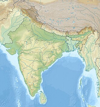 ทะเลสาบทาร์ซาร์ | |
| ที่ตั้ง | อำเภออนันต์นาครัฐชัมมูและแคชเมียร์ |
| พิกัด | 34°8′26″N 75°8′54″E / 34.14056°N 75.14833°E / 34.14056; 75.14833 |
| พิมพ์ | ทะเลสาบที่มีสารอาหารต่ำ |
| หิมะละลาย | |
| บาสไม นัลลา (สาขาของแม่น้ำลิดเดอร์ ) | |
| ประเทศในลุ่มน้ำ | อินเดีย |
| ความยาวสูงสุด | 2 กิโลเมตร (1.2 ไมล์) |
| ความกว้างสูงสุด | 0.8 กิโลเมตร (0.50 ไมล์) |
พื้นที่ผิว | 2 ตาราง กิโลเมตร(0.77 ตารางไมล์) |
ระดับความสูงของพื้นผิว | 3,795 เมตร (12,451 ฟุต) |
| แช่แข็ง | เดือนธันวาคมถึงมีนาคม |
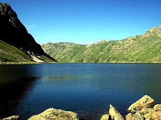
ทะเลสาบทาร์ซาร์หรือทาร์ซาร์เป็นทะเลสาบ อัลไพน์รูปทรงอั ลมอนด์ที่มีสารอาหารต่ำ ตั้งอยู่ในเขตอนันต์นาคของรัฐชัมมูและแคชเมียร์ ทางด้านตะวันตกติดกับอุทยานแห่งชาติดาชิกัมและทางด้านใต้ติดกับทราลเส้นทางที่สั้นที่สุดในการไปถึงทะเลสาบคือจากเซอร์ฟราว กันเดอร์บัลแต่เป็นเส้นทางที่มีภูมิประเทศยากลำบาก เส้นทางเดินป่าอื่นๆ ไปยังทะเลสาบมาจากพื้นที่ป่าลิเดอร์วัตและนากาเบรัน ซึ่งอยู่ในแคชเมียร์ตอนใต้[ 1 ] [ 2 ]
ภูมิศาสตร์
ทะเลสาบทาร์ซาร์ถูกล้อมรอบด้วยยอด เขา โคลาโฮอีซึ่ง อยู่ห่างออกไปทางทิศตะวันออกประมาณ 20 กิโลเมตร ทะเลสาบแห่งนี้ถูกคั่นด้วยภูเขาที่มีความสูงยอดเขาต่ำสุด 4,000 เมตร (13,000 ฟุต)จากทะเลสาบอีกแห่งที่มีลักษณะคล้ายกันซึ่งรู้จักกันในชื่อทะเลสาบมาร์ซาร์ซึ่งอยู่ใกล้กับอุทยานแห่งชาติดาชิกัม [ 3 ] ทะเลสาบทั้งสองนี้ถูกเรียกว่าพี่น้องฝาแฝด[ 4 ]ยูซุฟ ชาห์ ชัคผู้ปกครองแคชเมียร์ในศตวรรษที่ 16 ได้กล่าวถึงทะเลสาบฝาแฝดนี้ในบทกวีของเขา โดยเขียนถึงคนรักของเขาว่า:
เมื่อฉันนึกถึงผมสองเส้นของคนรักที่งดงาม น้ำตาก็ไหลรินจากดวงตาของฉันราวกับสายธารจากทาร์ซาร์และมาร์ซาร์[ 4 ]
The Tarsar Lake is drained by an outlet stream which falls into the Lidder River at Lidderwat, 15 km to the east. Being the nearest seasonal settlement, Lidderwat is located on the trek route to the lake from Aru, Pahalgam. The Marsar Lake on the other hand drains out and flows in the opposite direction of the Tarsar Lake.[1][3][5][6]
Flora and fauna
During the winter, the Tarsar Lake freezes and is covered by heavy snow; it has floating ice even in the summer. The basin of the lake is surrounded by a sheet of alpine flowers. The geum, blue poppy, potentilla and gentian are relatively common. Hedysarum flowers are found in late spring throughout the area around the lake.[7][8]
During summer there are breeding colonies of migratory birds, including bar-headed geese, lammergeyers, high-flying choughs, Himalayan golden eagles, cinnamon sparrows and black bulbuls. The basin of Tarsar and the adjoining Dachigam National Park constitute one of the most important habitats of the Kashmir stag (hangul), ibex, musk deer, snow leopard, Himalayan brown bear and in the higher reaches, the golden marmot.[9]
Access
The Tarsar Lake is accessible only during the summer preferably from June to Mid September; during the winter, the treks are closed because of the heavy snowfall. It can be reached from Srinagar, via a 102 km motorable road which leads through Anantnag and Pahalgam to the Aru trekking camp. The alpine meadow of Lidderwat lies at the halfway point of the two-day trek to the lake and happens to be mostly the basecamp for most of the trekkers. One could visit the lake and come back to his basecamp at Lidderwat in the same day.
An alternate route leads through Ganderbal and a trekking starting point at Surfraw in the Sind Valley. Due to the steepness of the trek, it is preferable to approach the lake by the Aru-Lidderwat trek and return via the Surfraw Sind Valley trek. On this route, walkers may see the Uppar portion and Nallah of Surfraw (Soraf Raw) village.[5] Another accessible route to Tarsar and Marsar is a place called Naga-Baren via Tral.