
Tha Yang district
Tha Yang ท่ายาง | |
|---|---|
 Tung Ngam Lake, Khao Krapuk, Tha Yang District | |
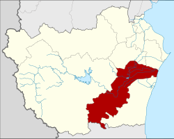 District location in Phetchaburi province | |
| Coordinates: 12°58′24″N99°53′16″E / 12.97333°N 99.88778°E / 12.97333; 99.88778 | |
| Country | Thailand |
| Province | Phetchaburi |
| Area | |
• Total | 736.7 km2 (284.4 sq mi) |
| Population (2000) | |
• Total | 80,794 |
| • Density | 109.7/km2 (284/sq mi) |
| Time zone | UTC+7 (ICT) |
| Postal code | 76130 |
| Geocode | 7605 |
Tha Yang (Thai: ท่ายาง, pronounced[tʰâːjāːŋ]) is a district (amphoe) in the southern part of Phetchaburi province, western Thailand.
Etymology
In 1910, the western part of the district (which now is Kaeng Krachan district) was covered by dense forest. The main trees are Makha (Monkey Pod wood, Afzelia xylocarpa), Takhian (Ironwood, Hopea odorata) and Yang (Dipterocarpus alatus). Thus when the government established the district, they named it Tha Yang (literally, 'Yang tree pier').
History
The district was originally named Yang Yong, and was renamed Tha Yang in 1939.[1]
Geography
Neighboring districts are (from the north clockwise) Mueang Phetchaburi, Ban Lat, Kaeng Krachan of Phetchaburi Province, Hua Hin of Prachuap Khiri Khan province, Cha-am of Phetchaburi Province and the Gulf of Thailand.
Administration
The district is divided into 12 sub-districts (tambons), which are further subdivided into 119 villages (mubans). Tha Yang and Nong Chok are two townships (thesaban tambon): Tha Yang covers the whole tambon Tha Yang and parts of Tha Khoi, while Nong Chok covers parts of the same-named tambon. There are a further 12 tambon administrative organizations (TAO).
| 1. | Tha Yang | ท่ายาง | |
| 2. | Tha Khoi | ท่าคอย | |
| 3. | Yang Yong | ยางหย่อง | |
| 4. | Nong Chok | หนองจอก | |
| 5. | Map Pla Khao | มาบปลาเค้า | |
| 6. | Tha Mai Ruak | ท่าไม้รวก | |
| 7. | Wang Khrai | วังไคร้ | |
| 8. | Klat Luang | กลัดหลวง | |
| 9. | Puek Tian | ปึกเตียน | |
| 10. | Khao Krapuk | เขากระปุก | |
| 11. | Tha Laeng | ท่าแลง | |
| 12. | Ban Nai Dong | บ้านในดง |
เลขที่บ้านที่หายไปเป็นของตำบลซึ่งปัจจุบันอยู่ในเขตอำเภอแก่งกระจาน
ลิงก์ภายนอก
- amphoe.com
 | บทความเกี่ยวกับจังหวัดเพชรบุรีนี้ ยัง ไม่สมบูรณ์คุณสามารถช่วยวิกิพีเดียได้โดยการเพิ่มข้อมูลที่ขาดหายไป |