
Virginia State Route 153
 State Route 153 | ||||
|---|---|---|---|---|
 | ||||
| Route information | ||||
| Maintained by VDOT | ||||
| Length | 17.15 mi[1] (27.60 km) | |||
| Existed | 1933–present | |||
| Major junctions | ||||
| South end |  US 460 near Blackstone US 460 near Blackstone | |||
  SR 38 / SR 602 at Scotts Fork SR 38 / SR 602 at Scotts Fork | ||||
| North end |  US 360 near Winterham US 360 near Winterham | |||
| Location | ||||
| Country | United States | |||
| State | Virginia | |||
| Counties | Nottoway, Amelia | |||
| Highway system | ||||
| ||||


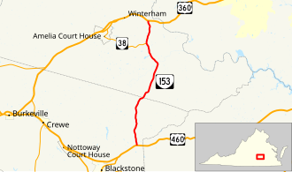
State Route 153 (SR 153) is a primary state highway in the U.S. state of Virginia. The state highway runs 17.15 miles (27.60 km) from U.S. Route 460 (US 460) near Blackstone north to US 360 near Winterham. SR 153 is the primary north–south highway of eastern Amelia County. The state highway also provides a connection between Blackstone and Richmond in conjunction with US 360.
Route description

SR 153 begins at an intersection with US 460 (Colonial Trail Highway) at the eastern edge of Nottoway County northeast of Blackstone. The state highway heads north as Rocky Hill Road. SR 153 becomes Military Road when entering Amelia County. The state highway then passes through the hamlets of Earls and Wilsons Corner. After crossing Deep Creek, a tributary of the Appomattox River, SR 153 meets the eastern end of SR 38 (Five Forks Road), which heads west to Amelia Court House, at Scotts Fork. The state highway has its northern terminus at US 360 (Patrick Henry Highway) east of Winterham.[1][2]
Major intersections
| County | Location | mi[1] | km | Destinations | Notes |
|---|---|---|---|---|---|
| Nottoway | | 0.00 | 0.00 | US 460 (Colonial Trail Highway) | Southern terminus |
| Amelia | | 11.2 | 18.0 |  SR 708 (Cralles Road) – Mannboro, Sutherland SR 708 (Cralles Road) – Mannboro, Sutherland | former SR 38 east |
| Scotts Fork | 14.23 | 22.90 |  SR 38 west (Five Forks Road) / SR 602 (Bevils Bridge Road) – Amelia SR 38 west (Five Forks Road) / SR 602 (Bevils Bridge Road) – Amelia | former planned SR 153 north | |
| | 17.15 | 27.60 | US 360 (Patrick Henry Highway) – Amelia, Danville, Richmond | Northern terminus | |
| 1.000 mi = 1.609 km; 1.000 km = 0.621 mi | |||||
ลิงก์ภายนอก

- โครงการทางหลวงเวอร์จิเนีย: VA 153