
ทางหลวงรัฐวอชิงตันหมายเลข 116
 ทางหลวงรัฐหมายเลข 116 | ||||
|---|---|---|---|---|
 SR 116 ที่ไฮไลต์ด้วยสีแดง | ||||
| ข้อมูลเส้นทาง | ||||
| เส้นทางเสริมของทางหลวงหมายเลข 101 ของ สหรัฐอเมริกา | ||||
| ดูแลรักษาโดยWSDOT | ||||
| ความยาว | 9.83 ไมล์[ 1 ] (15.82 กม.) | |||
| มีอยู่ | 1991 [ 2 ] –ปัจจุบัน | |||
| จุดเชื่อมต่อหลัก | ||||
| ฝั่งตะวันตก |  SR 19ในพอร์ตแฮดล็อค-ไอรอนเดล SR 19ในพอร์ตแฮดล็อค-ไอรอนเดล | |||
| ฝั่งตะวันออก | อุทยานแห่งรัฐฟอร์ตแฟลกเลอร์ | |||
| ที่ตั้ง | ||||
| ประเทศ | สหรัฐอเมริกา | |||
| สถานะ | วอชิงตัน | |||
| เขตปกครอง | เจฟเฟอร์สัน | |||
| ระบบทางหลวง | ||||
| ||||


ทางหลวงรัฐหมายเลข 116 ( SR 116 ) เป็นทางหลวงของรัฐที่มีความยาว 9.83 ไมล์ (15.82 กิโลเมตร)ในรัฐวอชิงตันของ สหรัฐอเมริกา ซึ่งเชื่อมต่อ เกาะ อินเดียนและ เกาะ มาร์โรว์สโตนในเทศมณฑลเจฟเฟอร์สัน ทางหลวงสองเลนนี้วิ่งไปทางทิศตะวันออกจาก ทางหลวง รัฐหมายเลข19ในพอร์ตแฮดล็อก-ไอรอนเดลข้ามคลองพอร์เทจไปยังเกาะอินเดียนและเกาะมาร์โรว์สโตน จากนั้นเลี้ยวไปทางทิศเหนือและสิ้นสุดที่ทางเข้าอุทยานแห่งรัฐฟอร์ตแฟลกเลอร์ ทางหลวงรัฐหมายเลข116 สร้างขึ้นในปี 1991 และใช้เส้นทางเดียวกับถนนแฟลกเลอร์ ซึ่งสร้างและลาดยางในช่วงทศวรรษ 1960
คำอธิบายเส้นทาง

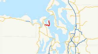
SR 116 เริ่มต้นที่ทางแยกกับSR 19ในPort Hadlock-Irondaleซึ่งตั้งอยู่ระหว่างPort LudlowและPort Townsendทางหลวงสายนี้วิ่งไปทางทิศตะวันออกในชื่อ Nees' Corner Road ข้ามChimacum Creekและผ่านชุมชน Port Hadlock ก่อนที่จะข้ามคลองPortageไปยังเกาะ Indian Island SR 116 ยังคงวิ่งไปทางทิศตะวันออกบนเกาะ Indian Island ในชื่อ Flagler Road เลียบชายฝั่ง Oak Bay และเลี้ยวไปทางทิศเหนือเลียบ Scow Bay ไปยังเกาะ Marrowstoneเข้าสู่พื้นที่ป่า ทางหลวงยังคงวิ่งไปทางทิศเหนือผ่านใจกลางเกาะ Marrowstone และผ่านอุทยานแห่งรัฐ Mystery Bayก่อนที่จะสิ้นสุดที่ทางเข้าอุทยานแห่งรัฐ Fort Flagler [ 3 ] [ 4 ] [ 5 ]
Every year, the Washington State Department of Transportation (WSDOT) conducts a series of surveys on its highways in the state to measure traffic volume. This is expressed in terms of annual average daily traffic (AADT), which is a measure of traffic volume for any average day of the year. In 2011, WSDOT calculated that the busiest section of the highway was its western terminus at SR 19, carrying 6,500 vehicles, while the least busiest section was the eastern terminus at Fort Flagler State Park, carrying 440 vehicles.[6] SR 116 is designated as a part of the National Highway System between SR 19 and Indian Island.[7]
History
A road connecting Fort Flagler State Park and Marrowstone Island with Indian Island and Port Hadlock-Irondale on the Olympic Peninsula has existed and been paved since the late 1960s.[8] The roadway was codified in 1991 as SR 116, traveling east from newly created SR 19 and was formally added to the state highway system on April 1, 1992.[2][9] The bridge over the Port Townsend Ship Canal, also known as the Portage Canal, was retrofitted by WSDOT in late 2007 and early 2008 to add safer railings for pedestrians.[10]
Major intersections
The entire highway is in Jefferson County.
| Location | mi[1] | km | Destinations | Notes | |
|---|---|---|---|---|---|
| Port Hadlock-Irondale | 0.00 | 0.00 | SR 19 – Chimacum, Port Townsend | Western terminus | |
| Fort Flagler State Park | 9.83 | 15.82 | Park entrance | Eastern terminus, continues as Flager Road | |
| 1.000 mi = 1.609 km; 1.000 km = 0.621 mi | |||||
ลิงก์ภายนอก
- ทางหลวงของรัฐวอชิงตัน