
ทางหลวงรัฐวอชิงตันหมายเลข 433

 ทางหลวงรัฐหมายเลข 433 | ||||
|---|---|---|---|---|
| โอเรกอนเวย์ | ||||
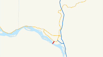 SR 433 ที่ไฮไลต์ด้วยสีแดง | ||||
| ข้อมูลเส้นทาง | ||||
| ดูแลรักษาโดยWSDOT | ||||
| ความยาว | 0.94 ไมล์[ 1 ] (1,510 เมตร) | |||
| มีอยู่ | ปี 1964–ปัจจุบัน | |||
| จุดเชื่อมต่อหลัก | ||||
| ปลายด้านใต้ |   ไปยัง ทางหลวง หมายเลข 30 ของสหรัฐฯ ในเมืองเรนเนียร์ รัฐโอเรกอน ไปยัง ทางหลวง หมายเลข 30 ของสหรัฐฯ ในเมืองเรนเนียร์ รัฐโอเรกอน | |||
| ฝั่งเหนือ |  SR 432ในลองวิว SR 432ในลองวิว | |||
| ที่ตั้ง | ||||
| ประเทศ | สหรัฐอเมริกา | |||
| สถานะ | วอชิงตัน | |||
| เขตปกครอง | คาวลิทซ์ | |||
| ระบบทางหลวง | ||||
| ||||

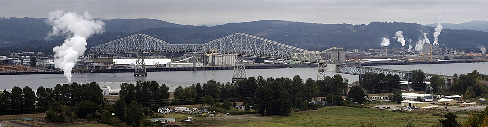
ทางหลวงรัฐหมายเลข 433 ( SR 433 ) เป็นทางหลวงรัฐที่มีความยาว0.94 ไมล์ (1.51 กิโลเมตร)ตั้งอยู่ในเขตเคาว์ลิทซ์ รัฐวอชิงตันสหรัฐอเมริกาทางหลวงสายนี้เริ่มต้นจากกลางแม่น้ำโคลัมเบียบนสะพานลูอิสและคลาร์กซึ่งได้รับการขึ้นทะเบียนเป็นสถานที่ทางประวัติศาสตร์แห่งชาติและทอดยาวไปทางเหนือจนถึงทางหลวงรัฐหมายเลข 432ในลองวิวก่อนการเปลี่ยนหมายเลขทางหลวงรัฐในปี 1964ทางหลวงสายนี้เป็นส่วนหนึ่งของทางหลวงรัฐสายหลักหมายเลข 12ระหว่างปี 1964 ถึง 1972 การกำหนดหมายเลขทางหลวงได้เปลี่ยนจากทางหลวงรัฐหมายเลข 833 เป็นทางหลวงรัฐหมายเลข 433 ในปัจจุบัน
คำอธิบายเส้นทาง
ทางหลวงหมายเลข 433 (SR 433) เข้าสู่เขตวอชิงตันและเคาน์ตีคาวลิทซ์ บนสะพานลูอิสและคลาร์กที่ขึ้นทะเบียนเป็นสถานที่ทางประวัติศาสตร์แห่งชาติ ข้ามแม่น้ำโคลัมเบีย ทางหลวงวิ่งไปทางตะวันออกเฉียงเหนือตามสะพานเป็นระยะทาง0.54 ไมล์ (0.87 กิโลเมตร)ก่อนที่จะลงไปยังเมืองและท่าเรือลองวิว โดยตัดกับถนนทางเข้าท่าเรือ พอร์ตเวย์ ทางหลวงยังคงมุ่งหน้าไปทางเหนือ ขนานไปกับรางรถไฟของทางรถไฟโคลัมเบียและคาวลิทซ์ [ 2 ] ตัดกับพอร์ตเวย์อีกครั้ง และเพิ่มเลนอีกหนึ่งเลนในแต่ละทิศทาง รวมเป็นสี่เลน ก่อนที่ทางหลวงจะสิ้นสุดที่ทางแยกกับทางหลวงหมายเลข432 (SR 432) และอินดัสเทรียลเว ย์ [ 3 ]ทางหลวงมีป้ายจำกัดความเร็ว35 ไมล์ต่อชั่วโมง (56 กิโลเมตรต่อชั่วโมง)ตลอดเส้นทาง[ 1 ]โอเรกอนเวย์ยังคงดำเนินต่อไปหลังจากสิ้นสุดทางหลวงหมายเลข433 เข้าสู่ใจกลางเมืองลองวิวและ ทางหลวงหมายเลข 4 (SR 4 ) [ 3 ]
Every year the Washington State Department of Transportation (WSDOT) conducts a series of surveys on its highways in the state to measure traffic volume. This is expressed in terms of annual average daily traffic (AADT), which is a measure of traffic volume for any average day of the year. In 2009, WSDOT calculated 20,000 vehicles use the highway, with 12 percent of that traffic being trucks.[4] The entire highway is listed on both the WSDOT List of Highways of Statewide Significance,[5] which marks this portion of the highway as critical to connecting major communities in the state, and the National Highway System, a system of roads that are important to the nation's economy, defense and mobility.[6]
SR 433 and the Lewis and Clark Bridge form part of the Seattle to Portland Bicycle Classic, serving as the link between Washington and Oregon on the 202 mi (325 km) long bicycle race held annually.[7]
History
Before the 1964 state highway renumbering the highway was part of Primary State Highway 12.[8] Sometime between the renumbering and 1972 the highway was renumbered from SR 833, a branch of U.S. Route 830 (US 830), to the current SR 433,[9] a branch of SR 4, which replaced US 830 through the area. SR 433 originally terminated at Tennant Way,[10] but was truncated to Industrial Way in 1991 as part of the relocation of SR 432.[11]
Major intersections
The entire highway is in Cowlitz County.
| Location | mi[1] | km | Destinations | Notes | |
|---|---|---|---|---|---|
| Columbia River | 0.00–0.54 | 0.00–0.87 | Lewis and Clark BridgeWashington–Oregon state line | ||
| Longview | 0.94 | 1.51 | SR 432 (Industrial Way) | To I-5 via SR 432 | |
| 1.000 mi = 1.609 km; 1.000 km = 0.621 mi | |||||
ลิงก์ภายนอก
- ทางหลวงของรัฐวอชิงตัน
- กล้องจราจร WSDOT