
Wat Bot district
Wat Bot วัดโบสถ์ | |
|---|---|
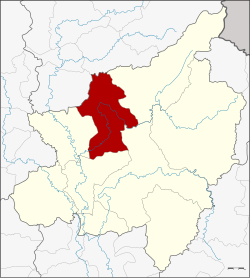 District location in Phitsanulok province | |
| Coordinates: 16°58′49″N100°20′0″E / 16.98028°N 100.33333°E / 16.98028; 100.33333 | |
| Country | Thailand |
| Province | Phitsanulok |
| Area | |
• Total | 1,326.2 km2 (512.0 sq mi) |
| Population (2025) | |
• Total | 36,633 |
| • Density | 27/km2 (70/sq mi) |
| Time zone | UTC+7 (ICT) |
| Postcode | 65160 |
| Calling code | 055 |
| ISO 3166 code | TH-6507 |
| LAO code | 02650700 |
Wat Bot (Thai: วัดโบสถ์, pronounced[wátbòːt]) is a district (amphoe) in the northern part of Phitsanulok province, lower northern region of Thailand.
History
Tambon Wat Bot was separated from the Phrom Phiram district and created as a minor district (king amphoe) on 1 January 1948. It was upgraded to a full district on 6 June 1956. The present district office was opened on 4 July 1991.
Geography
Neighboring districts are (from the east clockwise), Chat Trakan, Wang Thong, Mueang Phitsanulok, and Phrom Phiram of Phitsanulok Province; Phichai and Thong Saen Khan of Uttaradit province.
Wat Bot lies within the Nan Basin, which is part of the Chao Phraya Watershed. The Khwae Noi River flows through Wat Bot District.
Portions of Wat Bot are part of the Khwae Noi National Reserved Forest, which was recently made part of Kaeng Chet Khwae National Park.[1]
Administration
Provincial government
The district is divided into six subdistricts (tambons), which are further subdivided into 61 villages (mubans), as of 2025: 36,633 people of 16,103 families.[2]
| No | Subdistrict | Population | Villages |
|---|---|---|---|
| 1 | Wat Bot | 7,639 | 10 |
| 2 | Tha Ngam | 6,264 | 13 |
| 3 | Thothae | 6,352 | 8 |
| 4 | Ban Yang | 6,280 | 11 |
| 5 | Hin Lat | 4,545 | 9 |
| 6 | Khan Chong | 5,553 | 10 |
| Total population | 36,633 | 61 |
Local government
There is one subdistrict municipality (thesaban tambon}. Wat Bot municipality covers parts of villages 1 - 4, 7, 8 of Wat Bot, parts of villages 3, 4, 11, 12 of Tha Ngam, parts of 2 - 4 of Thothae subdistricts.
| Wat Bot subdistrict municipality | Population |
|---|---|
| Wat Bot subdistrict | 5,086 |
| Thothae subdistrict | 1,683 |
| Tha Ngam subdistrict | 998 |
| Total Population | 7,767 |
Further there are six subdistrict administrative organizations (SAO). Wat Bot, Thothae and Tha Ngam SAO's cover the remaining areas of Wat Bot, Thothae and Tha Ngam subdistricts. So the other three SAO's cover the whole same-named subdistrict.[3]
Temples
There are 34 active Buddhist temples in Wat Bo District.[4]
Transportation
The main roadway from Wat Bot to the rest of the province is Phitsanulok-Wat Bot Road.
Khwae Noi Dam project
Construction of the new dam was to have been completed in 2007 on the 60th anniversary of the king's accession to the throne. Among the areas to be irrigated by the dam's reservoir are Tambon Thap Yai Chiang of Phrom Phiram district, and the Thothae and Tha Ngam Subdistricts of Wat Bot. Construction of the dam was completed in 2008.
Economy
Wat Bot is a district on the outskirts of Phitsanulok province, most of the area is in the reserved forest.
Therefore, Wat Bot and two neighboring districts, Nakhon Thai and Chart Trakan, have the lowest prosperity index in Phitsanulok, lowest household income and highest household debt.[5]
External links
- amphoe.com (Thai)