
วินสตัน รัฐโอเรกอน
วินสตัน รัฐโอเรกอน | |
|---|---|
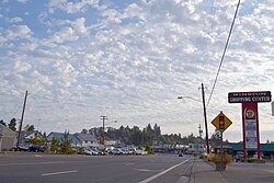 | |
| ภาษิต: "บ้านแห่งการท่องเที่ยวซาฟารีชมสัตว์ป่า" | |
 ตั้งอยู่ในรัฐโอเรกอน | |
| พิกัด: 43°07′21″N 123°25′48″W / 43.12250°N 123.43000°W / 43.12250; -123.43000 | |
| ประเทศ | สหรัฐอเมริกา |
| สถานะ | โอเรกอน |
| เขต | ดักลาส |
| บริษัทจำกัด | 1955 ( 1955 ) |
| รัฐบาล | |
| • นายกเทศมนตรี | คริสตี้ เกล็น คนุตสัน[ 1 ] |
| พื้นที่ | |
• ทั้งหมด | 2.76 ตารางไมล์ (7.15 ตารางกิโลเมตร ) |
| • ที่ดิน | 2.76 ตารางไมล์ (7.15 ตารางกิโลเมตร ) |
| • น้ำ | 0 ตารางไมล์ (0.00 ตารางกิโลเมตร ) |
| ระดับความสูง | 528 ฟุต (161 เมตร) |
| ประชากร | |
• ทั้งหมด | 5,625 |
| • ความหนาแน่น | 2,037.4/ตร.ไมล์ (786.66/ ตร.กม. ) |
| เขตเวลา | เวลา 8.00 น. ตามเวลาภาคแปซิฟิก |
| • ฤดูร้อน ( เวลาออมแสง ) | เวลา 7.00 น. ตามเวลาภาคตะวันออกของสหรัฐอเมริกา (แปซิฟิก) |
| รหัสไปรษณีย์ | 97496 |
| รหัสพื้นที่ | 541 |
| รหัส FIPS | 41-83400 [ 5 ] |
| รหัสคุณลักษณะGNIS | 2412287 [ 3 ] |
| เว็บไซต์ | winstoncity.org |
วินสตันเป็นเมืองในเคาน์ตีดูลาสรัฐโอเรกอนสหรัฐอเมริกา ตั้งอยู่ห่างจากโรสเบิร์ก ไปทางตะวันตกเฉียงใต้ 7 ไมล์ [ 6 ]ประชากรมีจำนวน 5,379 คน ตามสำมะโนประชากรของสหรัฐอเมริกาในปี 2010วินสตันเป็นที่รู้จักกันดีในฐานะที่ตั้งของสวนสัตว์ซาฟารี
ประวัติศาสตร์
ในปี ค.ศ. 1920 ทางหลวงหมายเลข 99 ของรัฐโอเรกอนได้สร้างเสร็จสมบูรณ์ ซึ่งเชื่อมต่อเมืองวินสตันกับชุมชนดิลลาร์ด ที่อยู่ใกล้เคียงโดยตรง ซึ่งก่อนหน้านี้ถูกแยกออกจากกันด้วยแม่น้ำอัมป์ควา
ในปี 1953 เมืองนี้ได้รับการจัดตั้งขึ้นอย่างเป็นทางการภายใต้ชื่อ "Coos Junction" โดยมีการว่าจ้างนายทะเบียนเมืองคนแรก (Gene Geyer) ปีต่อมา Paul Bender ได้รับแต่งตั้งเป็นนายกเทศมนตรีของ Coos Junction และในปี 1955 กฎบัตรเมืองฉบับใหม่ได้รับการอนุมัติ และเมืองนี้ได้รับการเปลี่ยนชื่ออย่างเป็นทางการเป็น Winston
สวนสัตว์ซาฟารีเปิดให้บริการในปี 1972 ในปี 1986 ได้มีการสร้างรูปปั้นทองสัมฤทธิ์ขึ้นที่ทางแยกรูปสามเหลี่ยมใจกลางเมือง เพื่อรำลึกถึงคายัม เสือชีตาห์จากสวนสัตว์ซาฟารีที่เสียชีวิตด้วยภาวะไตวาย
ภูมิศาสตร์
ตามข้อมูลจากสำนักงานสำมะโนประชากรของสหรัฐอเมริกาเมืองนี้มีพื้นที่ทั้งหมด 2.65 ตารางไมล์ (6.86 ตารางกิโลเมตร)ซึ่งเป็นพื้นที่ดินทั้งหมด[ 7 ]
ภูมิอากาศ
เมืองวินสตันมีสภาพภูมิอากาศแบบเมดิเตอร์เรเนียน ทั่วไปของรัฐโอเรกอนตะวันตก ( Köppen Csb ) ซึ่งมีลักษณะเป็นฤดูร้อนแห้งแล้ง มีอากาศเย็นในตอนเช้าและร้อนในตอนบ่าย และฤดูหนาวที่หนาวเย็นและมีฝนตก
| ข้อมูลสภาพอากาศสำหรับเมืองวินสตัน รัฐโอเรกอน | |||||||||||||
|---|---|---|---|---|---|---|---|---|---|---|---|---|---|
| เดือน | ม.ค | กุมภาพันธ์ | มีนาคม | เมษายน | อาจ | จุน | กรกฎาคม | ส.ค. | กันยายน | ตุลาคม | พฤศจิกายน | ธันวาคม | ปี |
| บันทึกอุณหภูมิสูงสุด °F (°C) | 72 (22) | 78 (26) | 85 (29) | 95 (35) | 107 (42) | 110 (43) | 111 (44) | 110 (43) | 106 (41) | 101 (38) | 79 (26) | 73 (23) | 111 (44) |
| อุณหภูมิสูงสุดเฉลี่ยรายวัน °F (°C) | 49.6 (9.8) | 53.8 (12.1) | 58.7 (14.8) | 63.2 (17.3) | 70.4 (21.3) | 76.4 (24.7) | 84.7 (29.3) | 85.1 (29.5) | 79.4 (26.3) | 67.2 (19.6) | 54.1 (12.3) | 47.9 (8.8) | 65.9 (18.8) |
| อุณหภูมิต่ำสุดเฉลี่ยรายวัน °F (°C) | 36.0 (2.2) | 36.5 (2.5) | 38.5 (3.6) | 41.3 (5.2) | 46.3 (7.9) | 51.3 (10.7) | 55.6 (13.1) | 54.8 (12.7) | 50.0 (10.0) | 44.0 (6.7) | 40.0 (4.4) | 36.0 (2.2) | 44.2 (6.8) |
| บันทึกอุณหภูมิต่ำสุด °F (°C) | 9 (−13) | 3 (−16) | 25 (−4) | 26 (−3) | 29 (−2) | 36 (2) | 41 (5) | 41 (5) | 34 (1) | 21 (−6) | 12 (−11) | 3 (−16) | 3 (−16) |
| ปริมาณ น้ำฝนเฉลี่ย(มม.) | 5.02 (128) | 4.32 (110) | 3.86 (98) | 2.76 (70) | 1.92 (49) | 1.11 (28) | 0.42 (11) | 0.61 (15) | 1.21 (31) | 2.42 (61) | 6.10 (155) | 6.17 (157) | 35.92 (913) |
| ปริมาณหิมะเฉลี่ย (นิ้ว/ซม.) | 0 (0) | 0.3 (0.76) | 0 (0) | 0 (0) | 0 (0) | 0 (0) | 0 (0) | 0 (0) | 0 (0) | 0 (0) | 0 (0) | 0.2 (0.51) | 0.5 (1.3) |
| แหล่งที่มา: [ 8 ] [ 9 ] | |||||||||||||
ข้อมูลประชากร
| สำมะโนประชากร | โผล่. | บันทึก | %± |
|---|---|---|---|
| 1960 | 2,395 | — | |
| 1970 | 2,468 | 3.0% | |
| 1980 | 3,359 | 36.1% | |
| 1990 | 3,773 | 12.3% | |
| 2000 | 4,613 | 22.3% | |
| 2010 | 5,379 | 16.6% | |
| 2020 | 5,625 | 4.6% | |
| ปี 2021 (โดยประมาณ) | 5,665 | [ 10 ] | 0.7% |
| สำมะโนประชากรทุกสิบปีของสหรัฐอเมริกา[ 11 ] [ 4 ] | |||
สำมะโนประชากรปี 2020
As of the 2020 census, Winston had a population of 5,625. The median age was 41.1 years. 22.3% of residents were under the age of 18 and 20.9% of residents were 65 years of age or older. For every 100 females there were 96.0 males, and for every 100 females age 18 and over there were 92.9 males age 18 and over.[12][13]
98.2% of residents lived in urban areas, while 1.8% lived in rural areas.[14]
There were 2,280 households in Winston, of which 29.3% had children under the age of 18 living in them. Of all households, 43.5% were married-couple households, 18.0% were households with a male householder and no spouse or partner present, and 28.6% were households with a female householder and no spouse or partner present. About 25.7% of all households were made up of individuals and 12.7% had someone living alone who was 65 years of age or older.[12]
There were 2,384 housing units, of which 4.4% were vacant. Among occupied housing units, 64.9% were owner-occupied and 35.1% were renter-occupied. The homeowner vacancy rate was 1.1% and the rental vacancy rate was 3.6%.[12]
| Race | Number | Percent |
|---|---|---|
| White | 4,848 | 86.2% |
| Black or African American | 31 | 0.6% |
| American Indian and Alaska Native | 113 | 2.0% |
| Asian | 70 | 1.2% |
| Native Hawaiian and Other Pacific Islander | 1 | <0.1% |
| Some other race | 120 | 2.1% |
| Two or more races | 442 | 7.9% |
| Hispanic or Latino (of any race) | 313 | 5.6% |
2010 census
As of the 2010 census, there were 5,379 people, 2,140 households, and 1,483 families living in the city. The population density was 2,029.8 inhabitants per square mile (783.7/km2). There were 2,316 housing units at an average density of 874.0 per square mile (337.5/km2). The racial makeup of the city was 92.5% White, 0.3% African American, 1.6% Native American, 0.9% Asian, 0.1% Pacific Islander, 1.1% from other races, and 3.5% from two or more races. Hispanic or Latino of any race were 4.5% of the population.[5]
There were 2,140 households, of which 33.8% had children under the age of 18 living with them, 48.2% were married couples living together, 14.3% had a female householder with no husband present, 6.8% had a male householder with no wife present, and 30.7% were non-families. 24.0% of all households were made up of individuals, and 10.5% had someone living alone who was 65 years of age or older. The average household size was 2.50 and the average family size was 2.87.[5]
The median age in the city was 38.9 years. 24.5% of residents were under the age of 18; 8.1% were between the ages of 18 and 24; 24% were from 25 to 44; 26.2% were from 45 to 64; and 17% were 65 years of age or older. The gender makeup of the city was 48.6% male and 51.4% female.[5]
2000 census
As of the 2000 census, there were 4,613 people, 1,753 households, and 1,269 families living in the city. The population density was 2,152.5 inhabitants per square mile (831.1/km2). There were 1,892 housing units at an average density of 882.8 per square mile (340.9/km2). The racial makeup of the city was 94.58% White, 0.15% African American, 1.37% Native American, 0.52% Asian, 0.07% Pacific Islander, 1.24% from other races, and 2.08% from two or more races. Hispanic or Latino of any race were 2.84% of the population.[5]
There were 1,753 households, out of which 37.6% had children under the age of 18 living with them, 52.6% were married couples living together, 15.2% had a female householder with no husband present, and 27.6% were non-families. 21.8% of all households were made up of individuals, and 9.8% had someone living alone who was 65 years of age or older. The average household size was 2.61 and the average family size was 2.99.[5]
In the city, the population was spread out, with 28.8% under the age of 18, 9.9% from 18 to 24, 26.6% from 25 to 44, 20.5% from 45 to 64, and 14.2% who were 65 years of age or older. The median age was 34 years. For every 100 females, there were 93.2 males. For every 100 females age 18 and over, there were 87.3 males.[5]
The median income for a household in the city was $28,939, and the median income for a family was $36,006. Males had a median income of $30,909 versus $18,555 for females. The per capita income for the city was $13,299. About 13.7% of families and 16.9% of the population were below the poverty line, including 24.8% of those under age 18 and 11.8% of those age 65 or over.[5]
Education
เมืองวินสตันเป็นที่ตั้งของเขตการศึกษา Winston-Dillard ซึ่งประกอบด้วยโรงเรียนมัธยม Douglas High School , โรงเรียนมัธยมต้น Winston Middle School, โรงเรียนประถม Brockway Elementary, โรงเรียนประถม McGovern Elementary และโรงเรียนประถม Lookingglass Elementary นอกจากนี้ วินสตันยังเป็นที่ตั้งของโรงเรียนเอกชนระดับอนุบาลถึงมัธยมปลาย Umpqua Valley Christian School อีกด้วย
บุคคลสำคัญ
- จอช บิดเวลล์นักฟุตบอลอาชีพ เล่นให้กับทีมกรีนเบย์ แพ็กเกอร์ส และแทมปาเบย์ บัคคาเนียร์ส
- ทรอย โพลามาลูนักฟุตบอลอาชีพของทีมพิตต์สเบิร์ก สตีลเลอร์ส
เมืองพี่น้อง
เมืองวินสตันมีเมืองพี่น้องสองเมือง :
 โทโคโรอาประเทศนิวซีแลนด์
 หาดโรซาริโตประเทศเม็กซิโก
ลิงก์ภายนอก

- เว็บไซต์อย่างเป็นทางการ
- ข้อมูลเกี่ยวกับเมืองวินสตันในหนังสือบลูบุ๊คของรัฐโอเรกอน