
Zinder Region
Zinder | |
|---|---|
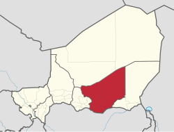 Location within Niger | |
| Coordinates: 13°42′N9°12′E / 13.700°N 9.200°E | |
| Country |  Niger Niger |
| Capital | Zinder |
| Government | |
| • Governor | Issa Moussa |
| Area | |
• Total | 145,430 km2 (56,150 sq mi) |
| Population (2020[1]) | |
• Total | 4,873,900 |
| • Density | 33.514/km2 (86.800/sq mi) |
| Time zone | UTC+1 (West Africa Time) |
| HDI (2021) | 0.384[2]low · 6th of 7 |
Zinder Region is one of the seven regions of Niger; the capital of the region is Zinder. The region covers 145,430 km². It is the most populous province of Niger.
History
Numerous Palaeolithic and Neolithic remains, as well as cave paintings, have been found in the Termit Massif.[3]
Zinder was the centre of the Sultanate of Damagaram, a powerful sultanate which dominated much of the surrounding region from the mid-18th century until the French conquest in the 1890s.[4] Zinder was initially the capital of the Niger territory. However, this was moved to Niamey in 1926 and thereafter Zinder declined in importance, though it remains an important regional centre.[3]
Geography
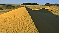
Zinder Region is located in the southeast of Niger and covers 145,430 km². It borders Agadez Region to the north, Diffa Region to the east, Nigeria to the south (specifically, the states of Yobe, Jigawa and Katsina), and Maradi Region to the west. The landscape is primarily Sahelian in the south, merging into the Sahara desert in the north of the region. The terrain is predominantly flat, except for the Koutous Hills, which lie north of Kelle, and the Termit Massif in the far north of the region.[3]
Settlements
ซินเดอร์เป็นเมืองหลวงของภูมิภาค การตั้งถิ่นฐานหลักอื่นๆ ได้แก่Alakoss , Albarkaram , Bande , Boune , Dakoussa , Dan-Barto , Dantchiao , Daouche , Dogo-Dogo , Falenko , Gaffati , Gamou , Garagoumsa , Gouchi , Gouna , Goure , Guidiguir , Hamdara , Ichirnawa , Kantche , Kelle , Kolleram , คูร์นี , กวายา , มากาเรีย , มาลาวา , มาตาเมเย , มิเรียห์ , โมอา , โอลเลวา , ซัสซูมโบรุม , ทา นูต์ , เทนห์ยา , เทสเกอร์ , ซาอูนี , ยาอูรีและเยโคอา[ 5 ]
หน่วยงานย่อยทางการปกครอง
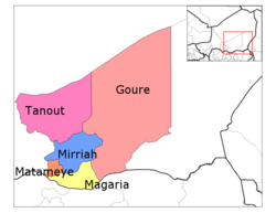
บริษัท Zinder แบ่งออกเป็น 5 แผนก :
จากสถานีบริหาร (postes administratifs) จำนวน 27 แห่งของประเทศไนเจอร์ ซึ่งกำหนดไว้ในกฎหมายลงวันที่ 1 สิงหาคม 2554 ให้เป็นแผนก และการแต่งตั้งผู้ว่าการเมื่อวันที่ 29 กุมภาพันธ์ 2555 ได้ทำให้การเปลี่ยนแปลงเสร็จสมบูรณ์ สถานีต่อไปนี้ 5 แห่งอยู่ในภูมิภาคซินเดอร์[ 6 ]
ดังนั้น ปัจจุบันซินเดอร์มี 10 แผนกและเมืองซินเดอร์[ 7 ]
ข้อมูลประชากร
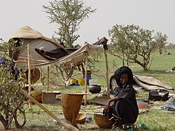
ณ ปี 2012 ประชากรของภูมิภาคมีจำนวน 3,539,764 คน[ 1 ]กลุ่มชาติพันธุ์และภาษาหลัก ได้แก่กลุ่มชาวอาหรับ ต่างๆ ชาวฟูลานี ชาวเฮาซาชาวคานูริ ชาวดาซากาตูบูและ ชาว ตูอาเร็กเช่นชาวตายาร์ต ทามาเจก [ 8 ] นอกจาก นี้ยังมีการพูด ภาษาตากดาลซึ่งเชื่อว่าเป็นภาษาผสมระหว่างภาษาซองฮายและ ภาษาตูอาเร็ก [ 8 ]
| ปี | โผล่. | ±% |
|---|---|---|
| พ.ศ. 2520 | 1,002,222 | — |
| พ.ศ. 2528 | 1,411,061 | +40.8% |
| 2001 | 2,080,250 | +47.4% |
| 2012 | 3,539,764 | +70.2% |
| แหล่งที่มา: [ 9 ] | ||
เศรษฐกิจ
ภูมิภาคนี้เป็นภูมิภาคที่ยากจนที่สุดในไนเจอร์และมีอัตราการเกิดความยากจนขั้นรุนแรง สูงที่สุด (ร้อยละ 60 ของประชากร) ตามข้อมูลของธนาคารโลก ในปี 2018 [ 10 ]ภูมิภาคนี้ยังได้รับผลกระทบอย่างหนักจากวิกฤตอาหารไนเจอร์ในปี 2005–2006 อีก ด้วย
ผู้ว่าการรัฐ
ดูเพิ่มเติม
ลิงก์ภายนอก

 คู่มือการเดินทางไป ยังเมืองซินเดอร์จาก Wikivoyage
 | บทความเกี่ยวกับสถานที่ตั้งในประเทศไนเจอร์นี้ ยัง ไม่สมบูรณ์คุณสามารถช่วยวิกิพีเดียได้โดยการเพิ่มข้อมูลที่ขาดหายไป |