
ระบบพิกัดแนวนอน
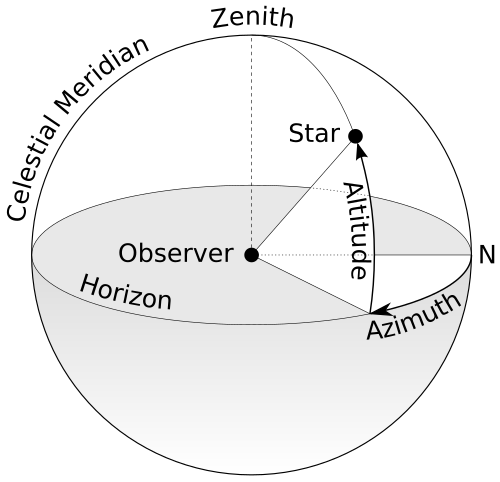
ระบบพิกัดแนวนอนเป็นระบบพิกัดท้องฟ้า ที่ใช้ ขอบฟ้าท้องถิ่นของผู้สังเกตการณ์เป็นระนาบพื้นฐานในการกำหนดมุมสองมุมของระบบพิกัดทรงกลมได้แก่มุมเงยและมุมอะซิมุธดังนั้น ระบบพิกัดแนวนอนจึงบางครั้งเรียกว่าระบบ az/el [ 1 ]ระบบalt/azหรือระบบalt-azimuthเป็นต้น ในฐานยึดแบบ altazimuthของกล้องโทรทรรศน์แกนทั้งสองของเครื่องมือจะตามมุมเงยและมุมอะซิมุธ[ 2 ]
คำนิยาม
ระบบพิกัดท้องฟ้านี้แบ่งท้องฟ้าออกเป็นสองซีกโลก : ซีกโลกบน ซึ่งมีวัตถุอยู่เหนือเส้นขอบฟ้าและมองเห็นได้ และซีกโลกล่าง ซึ่งมีวัตถุอยู่ใต้เส้นขอบฟ้าและมองไม่เห็น เนื่องจากโลกบดบังทัศนวิสัย[ a ]วงกลมใหญ่ที่แบ่งซีกโลกทั้งสองคือเส้นขอบฟ้าซึ่งกำหนดเป็นวงกลมใหญ่บนทรงกลมท้องฟ้าที่มีระนาบตั้งฉากกับเวกเตอร์แรงโน้มถ่วง เฉพาะที่ ( ทิศทางแนวตั้ง ) [ 3 ] [ a ]ในทางปฏิบัติ เส้นขอบฟ้าสามารถกำหนดได้ว่าเป็นระนาบที่สัมผัสกับพื้นผิวของเหลวที่นิ่ง เช่น สระน้ำปรอทหรือโดยใช้ระดับน้ำแบบวงกลม[ 4 ] ขั้วของซีกโลกบนเรียกว่าจุดสูงสุด (zenith)และขั้วของซีกโลกล่างเรียกว่าจุดต่ำสุด (nadir ) [ 5 ]
ต่อไปนี้เป็นพิกัดเชิงมุมแนว นอนอิสระสองพิกัด :
- ระดับความสูง (alt. หรือ มุมระดับความสูง[ b ] ) บางครั้งเรียกว่าระดับความสูง (el. หรือมุมระดับความสูง [ c ] ) หรือapparent height, is the angle between the object and the observer's local horizon. For visible objects, it is an angle between 0° and 90°.[d]
- Azimuth (az.) is the angle of the object around the horizon, usually measured from true north and increasing eastward. Exceptions are, for example, ESO's FITS convention where it is measured from the south and increasing westward, or the FITS convention of the Sloan Digital Sky Survey where it is measured from the south and increasing eastward.
A horizontal coordinate system should not be confused with a topocentric coordinate system. Horizontal coordinates define the observer's orientation, but not location of the origin, while topocentric coordinates define the origin location, on the Earth's surface, in contrast to a geocentric celestial system.
General features
The horizontal coordinate system is fixed to a location on Earth, not the stars. Therefore, the altitude and azimuth of an object in the sky changes with time, as the object appears to drift across the sky with Earth's rotation. In addition, since the horizontal system is defined by the observer's local horizon,[a] the same object viewed from different locations on Earth at the same time will have different values of altitude and azimuth.
The cardinal points on the horizon have specific values of azimuth that are helpful references.
| Cardinal point | Azimuth |
|---|---|
| North | 0° |
| East | 90° |
| South | 180° |
| West | 270° |
Horizontal coordinates are very useful for determining the rise and set times of an object in the sky. When an object's altitude is 0°, it is on the horizon.[a] If at that moment its altitude is increasing, it is rising, but if its altitude is decreasing, it is setting. However, all objects on the celestial sphere are subject to diurnal motion, which always appears to be westward.
A northern observer can determine whether altitude is increasing or decreasing by instead considering the azimuth of the celestial object:
- If the azimuth is between 0° and 180° (north–east–south), the object is rising.
- If the azimuth is between 180° and 360° (south–west–north), the object is setting.
There are the following special cases:[a]
- เมื่อมองจากขั้วโลกเหนือ ทุกทิศจะเป็นทิศใต้ และเมื่อมองจากขั้วโลกใต้ ทุกทิศจะเป็นทิศเหนือ ดังนั้นค่ามุมอะซิมุธจึงไม่แน่นอนในทั้งสองตำแหน่ง เมื่อมองจากขั้วโลกใดขั้วโลกหนึ่ง ดาวฤกษ์ (หรือวัตถุใดๆ ที่มีพิกัดเส้นศูนย์สูตร คงที่ ) จะมีระดับความสูงคงที่และจึงไม่ขึ้นหรือตก ส่วนดวงอาทิตย์ ดวงจันทร์และดาวเคราะห์ต่างๆสามารถขึ้นหรือตกได้ตลอดทั้งปีเมื่อมองจากขั้วโลก เนื่องจากค่าเดคลิเนชัน ของพวกมัน เปลี่ยนแปลงอยู่ตลอดเวลา
- เมื่อมองจากเส้นศูนย์สูตรวัตถุที่อยู่บริเวณขั้วฟ้าจะคงอยู่ที่จุดคงที่บนเส้นขอบฟ้า
ดูเพิ่มเติม
เชิงอรรถ
- 1 2 3 4 5โปรดทราบว่าเงื่อนไขพิเศษที่อธิบายไว้นั้นเป็นจริงเฉพาะในส่วนของ ขอบฟ้า ทางเรขาคณิตเท่านั้น กล่าวคือ ขอบฟ้าที่ ผู้สังเกตการณ์บนโลกที่เรียบสนิทปราศจากชั้นบรรยากาศ จะเห็น สำหรับผู้สังเกตการณ์ที่ระดับน้ำทะเลในทางปฏิบัติ ขอบฟ้า ที่ปรากฏจะมีระดับความสูงติดลบเล็กน้อยเนื่องจากความโค้งของโลก ซึ่งค่าจะติดลบมากขึ้นเมื่อผู้สังเกตการณ์ขึ้นไปสูงขึ้นเหนือระดับน้ำทะเลนอกจากนี้การหักเหของแสงในชั้นบรรยากาศ ทำให้วัตถุบนท้องฟ้าที่อยู่ใกล้ขอบฟ้ามากปรากฏ สูง กว่าปกติ ประมาณครึ่งองศาหากไม่มีชั้นบรรยากาศ
- ↑อย่าสับสนกับความสูง เชิงเส้น ซึ่งมีหน่วยเป็นความยาว
- ↑อย่าสับสนกับระดับความสูง เชิงเส้น ซึ่งมีหน่วยเป็นความยาว
- ↑อีกทางเลือกหนึ่งคือ สามารถใช้ มุมเงยแทนมุมเงยได้ เนื่องจากเป็นมุมเสริมกัน (ผลรวมของมุมเงยและมุมเงยคือ 90°)
- ↑ "(ระบบพิกัด Az,El)" หอดูดาว WM Keck มหาวิทยาลัยฮาวาย สืบค้นเมื่อ 18 พฤษภาคม 2021
- ↑ "ระบบเส้นขอบฟ้า" . สารานุกรมบริแทนนิกา .
- ↑ Clarke, D.; Roy, AE (2003). ดาราศาสตร์: หลักการและการปฏิบัติ (PDF) ( ฉบับที่ 4). บริสตอล สหราชอาณาจักร: สำนักพิมพ์สถาบันฟิสิกส์ หน้า59. ISBN 9780750309172เก็บถาวร(PDF)จากต้นฉบับเมื่อวันที่ 10 กรกฎาคม 2018 เรียกดูเมื่อวันที่ 9 กรกฎาคม 2018
- ↑ Young, Andrew T.; Kattawar, George W.; Parviainen, Pekka (1997). "วิทยาศาสตร์พระอาทิตย์ตก. I. ภาพลวงตา". Applied Optics . 36 (12): 2689– 2700. Bibcode : 1997ApOpt..36.2689Y . doi : 10.1364/ao.36.002689 . PMID 18253261 .
- ↑ Schombert, James. "ระบบพิกัดโลก"ภาควิชาฟิสิกส์มหาวิทยาลัยโอเรกอนสืบค้นเมื่อ 19 มีนาคม 2011
ลิงก์ภายนอก
- คำอธิบายเกี่ยวกับระบบพิกัดแนวนอน (วิดีโอ) เก็บถาวรจากต้นฉบับเมื่อวันที่ 12 พฤษภาคม 2558 –ผ่านทาง YouTube