
เทือกเขาชิลโคติน
| เทือกเขาชิลโคติน | |
|---|---|
 เทือกเขาชิลโคตินมีสีสันสดใสเนื่องจากมีแร่ธาตุอยู่มาก | |
| มิติ | |
| พื้นที่ | 9,616 ตาราง กิโลเมตร(3,713 ตารางไมล์) |
| ภูมิศาสตร์ | |
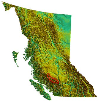 เทือกเขาชิลโคติน ตามที่กำหนดไว้ในหนังสือ " ลักษณะภูมิประเทศของเซาท์ฮอลแลนด์" ประจำรัฐบริติชโคลัมเบีย | |
ประเทศ | แคนาดา |
| บริติชโคลัมเบีย | |
พิกัดช่วง | 51°10′0″N 123°15′0″W / 51.16667°N 123.25000°W / 51.16667; -123.25000 [1] |
| ช่วงสำหรับผู้ปกครอง | เทือกเขาแปซิฟิก |
| ชายแดนติดกับ | ที่ราบชิลโคติน เทือกเขาแวดดิงตัน |
เทือกเขาชิลโคตินเป็นส่วนหนึ่งของเทือกเขาแปซิฟิกในเทือกเขาชายฝั่ง (ในบางการจัดประเภทถือเป็นส่วนย่อยแยกต่างหาก) ตั้งอยู่บนที่ราบลุ่มด้านในของเทือกเขาแปซิฟิกติดกับที่ราบสูงภายในของบริติชโคลัมเบียปลายด้านตะวันตกเฉียงเหนืออยู่ใกล้ต้นน้ำของแม่น้ำคลินาคลิ นี และปลายด้านตะวันออกเฉียงใต้คือแม่น้ำเฟรเซอร์ทางเหนือของเมืองลิลลูเอต ด้านเหนือของเทือกเขา ติดกับขอบที่ราบสูงในขณะที่ด้านใต้ติดกับฝั่งเหนือของแม่น้ำบริดจ์ในบางการนับ เทือกเขาไม่ได้ทอดยาวไปจนถึงแม่น้ำเฟรเซอร์แต่สิ้นสุดที่แม่น้ำยาลาคอม ซึ่งเป็นสาขาเหนือของแม่น้ำบริดจ์
ไม่ใช่ช่วงเดียว แต่เป็นกลุ่มของช่วงต่างๆ ซึ่งมักแตกต่างกันอย่างชัดเจน มีช่วงย่อยหลักๆ สามช่วง:
- ดิกสันเรนจ์
- เทือกเขาชูลัปส์
- เทือกเขาคาเมลส์ฟุต (ซึ่งบางนิยามจัดอยู่ในที่ราบสูงตอนใน )
ทางทิศตะวันตกของปลายด้านตะวันตกของเทือกเขาชิลโคติน และซึ่งบางคนถือว่าเป็นส่วนหนึ่งของกลุ่มเทือกเขานี้ ได้แก่:
ทางทิศใต้ของบริเวณนั้นคือเทือกเขาแวดดิงตันและทุ่งน้ำแข็งโฮมาทโก
อุทยานประจำจังหวัด
ในช่วงไม่กี่ปีที่ผ่านมา มีการจัดตั้งอุทยานแห่งชาติและพื้นที่คุ้มครองขนาดใหญ่หลายแห่งในส่วนกลางและตะวันออกของเทือกเขาชิลโคติน ได้แก่อุทยานแห่งชาติบิ๊กครีกอุทยานแห่งชาติทซิลอส ( โดยที่เครื่องหมาย '?' คือเสียงหยุดในลำคอ) และอุทยานแห่งชาติบิ๊กครีกรวมถึงพื้นที่คุ้มครองทะเลสาบ สปรูซ และพื้นที่คุ้มครองลำธารเชิร์น
ประวัติความเป็นมาของพื้นที่คุ้มครองทะเลสาบสปรูซ
ภูมิภาคนี้เป็นที่รู้จักกันทั่วไป (แต่ไม่ถูกต้อง) ในชื่อ "เซาท์ชิลโคติน" และเป็นเป้าหมายของการโต้เถียงกันอย่างยาวนานระหว่างขบวนการอนุรักษ์และข้อเสนอการขุดทรัพยากรมาตั้งแต่ทศวรรษ 1930 อุทยานแห่งชาติถูกจัดตั้งขึ้นในทศวรรษ 1990 แต่ถูกลดระดับลงในปี 2007 เป็นพื้นที่คุ้มครองทะเลสาบสปรูซสถานะทางการเมืองของพื้นที่ไม่แน่นอน และพื้นที่อนุรักษ์ลดลงอย่างมากจากข้อเสนอเดิมในการปกป้อง ซึ่งเริ่มต้นในทศวรรษ 1930 ในช่วงยุคเฟื่องฟูของ เมืองเหมือง ทองบริดจ์ริเวอร์ทางตอนใต้
ในอดีต บริเวณนี้เป็นเขตล่าสัตว์ของหัวหน้าเผ่าฮันเตอร์ แจ็ค แห่งทะเลสาบลิลลูเอตซึ่งธุรกิจล่าสัตว์ใหญ่ของเขาใช้พื้นที่ร่วมกับนักล่าจาก ชนเผ่าทซิ ล ห์คอต อิน การใช้พื้นที่ร่วมกันทางเหนือของแม่น้ำบริดจ์และลำธารกันครีกเป็นส่วนหนึ่งของการประนีประนอมเพื่อสันติภาพในช่วงต้นศตวรรษที่ 19 ซึ่งยุติสงครามอันยาวนานและนองเลือดระหว่างชนเผ่าของฮันเตอร์ แจ็คกับชนเผ่า ทซิ ลห์คอตอินเส้นทางจากบริเวณแม่น้ำบริดจ์ทอดผ่านเทือกเขาหลายแห่งในภูมิภาคไปยังทะเลสาบทาเซโกและทะเลสาบชิลโกในเขตชิลโคตินและยังทอดไปทางตะวันออกข้ามเทือกเขาคาเมลส์ฟุตไปยังแม่น้ำเฟรเซอร์ใกล้กับบิ๊กบาร์อีกด้วย
Though no mines have ever been found in the proposed protected area, other than a few marginal ones in the vicinity of Eldorado Mountain, the south flank of Big Dog Mountain at the northwest end of the Shulaps Range was the site of a major gold excitement in 1941, connected with the interests who then owned the Bralorne-Pioneer Mine mines nearby. Physically daunting efforts to reach the alpine-elevation mine site over the Shulaps Range in order to preserve rights to the claim in the allotted time period almost destroyed the large pack-train, but the papers got filed. Those claims were shuffled aside during World War II but remained on the map and are currently under exploitation as the Blue Creek Mine. Other large mine prospects in the area include copper diggings covering the slopes of Red Mountain, the highest in the Camelsfoot Range just north of the Blue Creek Mine.
The area's unique and distinct landscape and ecology, so different even from the rest of the Chilcotin Ranges or the rest of the Bridge River Country, is what made it stand out amid a region already wild and extremely beautiful and why it's a long-term candidate for protection. The neighbouring Dickson, Shulaps and Bendor Ranges are all unprotected and have been or are being heavily logged, except for special preserves in alpine areas of the Shulaps and in its neighbour to the east, the Camelsfoot Range.
Many on the environmentalist side hope that the creation of Tsʼilʔos and Big Creek Provincial Park will help shore up the protection of the Spruce Lake Protected Area. Hunting guide Ted (Chilco) Choate of Gaspard Lake, on the Chilcotin Plateau just northeast of the Spruce Lake Protected Area has joined in the call to combine all these three parks, plus the Churn Creek Protected Area to their northeast, plus some of the surrounding country and the deep, much higher heart of the Pacific Ranges into a National Park. Industry and government remain committed to shared use and sustainable planning.
Resource Interests
Mining interests in the area are few, although the area is rich in copper and there are rumours of pitchblende (which contains uranium), but in over 100 years of exploration no profitable deposits of anything have been found and no major mines established. In recent years, however, clearcut logging has penetrated the flanks of the area and pushed the boundaries of the park from south and east, feeding mills at Lillooet, British Columbia, and beyond in the Thompson-Okanagan. This has generated protests on both sides of the environment vs. resource quarrel, but also instigated a stakeholder committee known as an Integrated Resource Management Process Unit which has had varying degrees of success at resolving disputes and planning land-use in the region.
External links
- "Chilcotin Ranges". BC Geographical Names. Government of British Columbia – B.C. Geographical Names Office (BCGNO).
- Chilcotin Ranges in the Canadian Mountain Encyclopedia (contains descriptions of unnamed and unofficially named ranges and areas within the region)