
Coldwater Spring
| Coldwater Spring | |
|---|---|
| Mní Ówe Sní | |
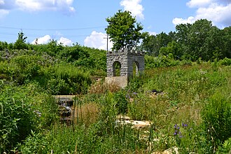 Coldwater Spring in July 2014 | |
 | |
| Location | Fort Snelling unorganized territory in the U.S. state of Minnesota |
| Nearest city | Minneapolis |
| Coordinates | 44°53.96′N93°11.77′W / 44.89933°เหนือ 93.19617°ตะวันตก |
| Governing body | U.S. National Park Service |
| Website | Coldwater Spring |
Mni Owe Sni - Coldwater Spring | |
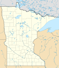  | |
| Location | Address Restricted, St. Paul, Minnesota |
| Area | 65.7 acres (26.6 ha) |
| NRHP reference No. | 100009497[1] |
| Added to NRHP | November 3, 2023 |
Coldwater Spring (Dakota: Mní Ówe Sní) is a spring in the Fort Snelling unorganized territory of the U.S. state of Minnesota, that is considered a sacred site by the Dakota people, and was also the site of the U.S. Army's Camp Coldwater for troops that constructed Fort Snelling. Coldwater Spring is located on the west bluffs of the Mississippi River directly south of Minnehaha Park and adjacent to Fort Snelling State Park. Waters from the naturally occurring spring flow continuously year round and remain unfrozen in winter months. The spring and surrounding area is managed as a protected historic site and natural park by the National Park Service as part of the Mississippi National River and Recreation Area.
History
First people
For thousands of years, Dakota people have considered the spring and area around it to be a place of spiritual importance.[2] The confluence of the Mississippi and Minnesota rivers was a neutral and sacred place where the Ojibwe, Dakota, Sauk, Meskwaki and Potowatamie tribes moved freely.[3]
Camp Coldwater
The spring area was explored by early European-American settlers who were interested in expanding the fur trade. In September 1805, the area was part of a 100,000-acre (400 km2) land purchased from the Mdewakanton SiouxIndians by Zebulon Pike.[4] The land was designated as a military reservation.
เมื่อวันที่ 5 พฤษภาคม ค.ศ. 1820 พันโทเฮนรี เลเวนเวิร์ธได้เคลื่อนย้ายกองทหารของเขาไปยังบริเวณบ่อน้ำพุ เนื่องจากค่ายเดิมของพวกเขาที่ริมแม่น้ำมินนิโซตาทำให้เกิดสภาพแวดล้อมที่ไม่ถูกสุขลักษณะ เลเวนเวิร์ธถูกแทนที่โดยพันเอกโจไซอาห์ สเนลลิงในเดือนสิงหาคมของปีเดียวกันนั้น ทหารอาศัยอยู่ในเต็นท์และกระท่อมในบริเวณนั้นเป็นเวลาสามฤดูร้อน ขณะที่พวกเขาสร้างป้อมปราการหินถาวรทางทิศใต้ของสถานที่ ซึ่งแล้วเสร็จในปี ค.ศ. 1825 และตั้งชื่อว่าป้อมสเนลลิงบ่อน้ำพุยังคงส่งน้ำไปยังป้อมอย่างต่อเนื่อง โดยเริ่มแรกผ่านทางรถบรรทุกน้ำ จากนั้นผ่านทางหอเก็บน้ำหินและท่อใต้ดิน
ผู้ตั้งถิ่นฐานที่ออกจากอาณานิคมแม่น้ำแดงได้มาตั้งรกรากใกล้กับแหล่งน้ำพุในปี พ.ศ. 2364 แต่ถูกบังคับให้ย้ายออกไปในปี พ.ศ. 2383 พวกเขาย้ายลงไปตามแม่น้ำมิสซิสซิปปีและตั้งรกรากในบริเวณที่ต่อมากลายเป็นเมืองเซนต์พอล รัฐมินนิโซตาบริเวณโคลด์วอเตอร์เคยมีร้านตีเหล็ก โรงเลี้ยงม้า สถานีการค้า โรงแรม และท่าเทียบเรือกลไฟ แต่อาคารเกือบทั้งหมดเหล่านั้นหายไปแล้วในช่วงสงครามกลางเมืองอเมริกา[ 5 ]
เมื่อป้อมสเนลลิงเปิดทำการอีกครั้งในช่วงสงครามกลางเมือง บ่อน้ำโคลด์วอเตอร์ก็ถูกนำมาใช้เพื่อจัดหาน้ำให้กับป้อมอีกครั้ง ในช่วงทศวรรษ 1880 กองทัพได้สร้างระบบประปาอย่างเป็นทางการ ณ สถานที่ดังกล่าว ซึ่งรวมถึงโรงเก็บน้ำพุและอ่างเก็บน้ำที่ยังคงอยู่[ 6 ]
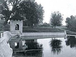
ศูนย์วิจัยเหมืองแร่
หลังจากการปิดป้อมสเนลลิงหลังสงครามโลกครั้งที่สองพื้นที่ดังกล่าวถูกส่งมอบให้กับสำนักงานเหมืองแร่แห่งสหรัฐอเมริกาเพื่อใช้เป็นศูนย์วิจัยทวินซิตี้ ซึ่งมีการดำเนินการวิจัยด้านเหมืองแร่เป็นเวลากว่า 40 ปี อาคารหลายหลังถูกสร้างขึ้นในช่วงทศวรรษ 1960 สำหรับคนงานกว่า 200 คน นักวิจัยในสถานที่แห่งนี้ได้รับการยกย่องว่าได้พัฒนาระบบกรองอากาศเพื่อกำจัดโรคปอดดำในหมู่คนงานเหมืองถ่านหินและสร้างอุปกรณ์ส่งเสียงเตือนเมื่อรถบรรทุกขนาดใหญ่กำลังถอยหลัง[ 7 ]ศูนย์วิจัยทวินซิตี้ปิดตัวลงในปี 1996 และอาคารหลายหลังถูกทิ้งร้าง[ 8 ]
การก่อสร้างทางหลวง
For many years, efforts to protect the spring delayed planned freeway construction in the area.[7] The Minnesota Department of Transportation set a national precedent in 2003 by welding 28,000 square yards of eight-layer synthetic liner, covering approximately six acres to protect the water flow to the spring. The liner isolated the interchange of Minnesota highways 55 and 62, allowing it to sit below the water table and remain dry, while also letting the water flow beneath the interchange to the spring.[9][10][11][7]
Ownership transition
The National Park Service led an environmental impact statement process in 2006 to consider potential future uses of the site that had been largely abandoned for the past ten years. If disposing of the site, the federal government was required by law to sell the land to a state or local government, American Indian tribe, or an academic institution. Some of the vacant mine research buildings may have been eligible for National Register for Historic Places status, but would have required expensive repairs. Hennepin County officials wanted to convert the site to a suburban business park. Conservationists argued that the spring area should be repurposed as a publicly accessible natural park.[7]
Coldwater Spring park
The property was transferred to the National Park Service in 2010, and made a unit of the Mississippi National River and Recreation Area. Plans to restore the native landscape led to discussion about Dakota history and ownership of the area.[2] The community at the Lower Sioux Indian Reservation designated Coldwater as a traditional cultural property, making an official statement that the area "has been used for traditional, spiritual, religious and cultural ceremonies by the MN. Mdewakanton and their hereditary descendents [sic] for thousands of years" and that "the water of Coldwater Spring has been traditionally utilized for healing of Dakota people and others."[12] The National Park Service held the view that while there were Dakota villages along the lower Minnesota River, there is little evidence the spring itself was a ceremonial site.[13]
National Park Service crews at Coldwater Spring repaired the springhouse structure, restored the creek and wetlands, removed invasive species like buckthorn, and removed several abandoned buildings. The result was a savanna landscape said to resemble pre-settlement by European-American people.[14] The National Park Service opened Coldwater Spring park to the public in 2012.[15]
Geology and hydrology
Coldwater Spring emanates from Platteville limestone bedrock near the river gorge that was formed over 10,000 years ago by glacier melt at the end of the most recent ice age. Water flows at 144,000 gallons per day at 47 °F (8 °C), remaining ice free in the winter with ducks present. Waters exit the spring into a reservoir before tumbling into a wetlands waterfall and eventually reaching the Mississippi River.[16] Water from Coldwater Spring is not considered drinkable.[17]
Landscape
The site was extensively re-landscaped in 2012 with native grasses and wildflowers in an attempt to restore the original oak savanna landscape.[18] Prairie restoration efforts had the similar aim as those at Bruce Vento Nature Sanctuary in Saint Paul a few years prior. Much of the restored landscape is maintained by NPS biological staff in partnership with biweekly volunteer crews.[15]
Recreation
The main features of Coldwater Spring park are walking paths through a tallgrass prairie, the naturally occurring spring, and the historic springhouse and reservoir.[19] There is a .25-mile (0.40 km) crushed limestone path from the entrance that winds through the restored savanna to the historic springhouse structure. Beyond the springhouse, a 1-mile (1.6 km) hiking trail crosses the creek into the nearby woodlands and connects with the multi-use Minnehaha Trail, leading northward to Minnehaha Park or southward to Fort Snelling State Park. Bird watching and wildlife viewing are popular activities for visitors. The park has limited parking and there is no visitor center or restroom facility.[20]
Quotes
Early in the Spring [of 1820] Col. Leavenworth discovered the fountain of water where the troops now are, & to which they moved as soon as the ice would permit. It is a healthy situation, about 200 feet above the river, and the water gushing out of a lime stone rock is excellent. It is called "Camp Cold Water".
— เจมส์ ดูแอน โดตี , แคมป์โคลด์วอเตอร์, 31 กรกฎาคม ค.ศ. 1820
[นี่คือ] สถานการณ์ที่เอื้อต่อสุขภาพเป็นอย่างยิ่ง และพวกเขาจะอยู่ที่นั่นต่อไปจนกว่าสิ่งก่อสร้างถาวร [ป้อมเซนต์แอนโทนี ซึ่งต่อมาคือป้อมสเนลลิง ] จะสร้างเสร็จบนหน้าผาตรงจุดบรรจบของแม่น้ำทั้งสองสาย
— เฮนรี สคูลคราฟต์ , 29 กรกฎาคม ค.ศ. 1820
เมื่อมาถึงที่นี่ ผมค่อนข้างประหลาดใจที่พบว่าไม่มีสถานที่ที่เรียกว่าเซนต์ปีเตอร์สอย่างแท้จริง ป้อมสเนลลิง นิวโฮป และแคมป์โคลด์วอเตอร์ รวมกันเป็นชุมชนทั้งหมดที่นี่ และดูเหมือนว่าชื่อเซนต์ปีเตอร์สจะถูกใช้โดยทั่วไปเพื่อเรียกชุมชนทั้งหมดรอบปากแม่น้ำเซนต์ปีเตอร์ส (แม่น้ำมินนิโซตา) ซึ่งไหลลงสู่แม่น้ำมิสซิสซิปปีที่นี่ ห่างจากน้ำตกเซนต์แอนโทนีไป ทางใต้เจ็ดไมล์
— เบนจามิน ที. คาวานอห์ 5 พฤศจิกายน 1839
เมื่อมองจากป้อมสเนลลิงจะเห็นเนินเขาที่สวยงามชื่อมอร์แกนส์บลัฟฟ์ ชาวอินเดียนแดงเรียกที่นี่ว่า 'บ้านของพระเจ้า' พวกเขามีประเพณีว่าที่นี่เป็นที่พำนักของเทพเจ้าแห่งน้ำของพวกเขา ซึ่งพวกเขาเรียกว่า อุนก์-ตา-เฮ[ 21 ]
— แมรี เฮนเดอร์สัน อีสต์แมน,หน้า 2, 1849
แกลเลอรี่
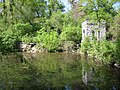 โรงเรือนน้ำพุและสระน้ำ พฤษภาคม 2550
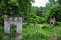 ภาพถ่ายศาลาพักแรมและภูมิทัศน์ในเดือนมิถุนายน ปี 2010 ก่อนที่กรมอุทยานแห่งชาติจะดำเนินการปรับปรุงภูมิทัศน์ในพื้นที่
 ประตูทางเข้าโคลด์วอเตอร์สปริงในวันที่สวนสาธารณะที่ได้รับการปรับปรุงภูมิทัศน์ใหม่เปิดให้ประชาชนเข้าชม เดือนกันยายน 2555
 บ่อน้ำโคลด์วอเตอร์ในวันที่สวนสาธารณะที่ได้รับการปรับปรุงภูมิทัศน์ใหม่เปิดให้ประชาชนเข้าชม เดือนกันยายน ปี 2012
 โรงเรือนน้ำพุและอ่างเก็บน้ำขนาดเล็กตั้งอยู่บริเวณปากน้ำพุโคลด์วอเตอร์ ในเดือนเมษายน 2559
ลิงก์ภายนอก

- แผนที่สวนสาธารณะโคลด์วอเตอร์สปริง