
ฟราโน, กิลกิต-บัลติสถาน
FranoหรือFranu [หมายเหตุ 1 ] ( ภาษาอูร์ ดู : فرانو , โรมันไนซ์ : frāno ) เป็นหมู่บ้านชายแดนและสภาตำบลที่ตั้งอยู่ในหุบเขา Chorbatในเขต Ghanche จังหวัด Gilgit -Baltistan [ 1 ] หมู่บ้านตั้งอยู่ริมฝั่งแม่น้ำ Shyokถือเป็นหมู่บ้านสุดท้ายของปากีสถาน โดยมีเส้นควบคุมชายแดน (LOC)อยู่ห่างออกไป 2.5 กิโลเมตร[ 2 ]
ฟราโนยังได้รับการกล่าวถึงในสื่อการท่องเที่ยวว่าเป็นหนึ่งในหมู่บ้านที่อยู่ทางตะวันออกสุดของปากีสถานในภูมิภาคบัลติสถาน และเป็นจุดชมวิวที่สามารถมองเห็นหมู่บ้านต่างๆ ที่อยู่ภายใต้การปกครองของอินเดียในหุบเขาชย็อค ได้
ประวัติศาสตร์


\", \"description\": \"Point on the Line of Control ([https://geohack.toolforge.org/geohack.php?params=34.75416;76.61777_dim:2000 34.75416,76.61777])\", \"marker-symbol\": \"-number-F11161\", \"marker-size\": \"medium\", \"marker-color\": \"#DB3123\" }, \"geometry\": {\"type\": \"Point\", \"coordinates\": [76.61777,34.75416] } }, { \"type\": \"Feature\", \"properties\": { \"title\": \"Hassanabad Chorbat
\", \"description\": \"Baltistan ([https://geohack.toolforge.org/geohack.php?params=34.97316;76.54094_dim:2000 34.97316,76.54094])\", \"marker-symbol\": \"-number-F11161\", \"marker-size\": \"medium\", \"marker-color\": \"#DB3123\" }, \"geometry\": {\"type\": \"Point\", \"coordinates\": [76.54094,34.97316] } }, { \"type\": \"Feature\", \"properties\": { \"title\": \"Siksa
\", \"description\": \"Principal village of Chorbat ([https://geohack.toolforge.org/geohack.php?params=34.931;76.616_dim:2000 34.931,76.616])\", \"marker-symbol\": \"-number-F11161\", \"marker-size\": \"medium\", \"marker-color\": \"#DB3123\" }, \"geometry\": {\"type\": \"Point\", \"coordinates\": [76.616,34.931] } }, { \"type\": \"Feature\", \"properties\": { \"title\": \"Dawou
\", \"description\": \"Western end of Chorbat ([https://geohack.toolforge.org/geohack.php?params=35.1083;76.4708_dim:2000 35.1083,76.4708])\", \"marker-symbol\": \"-number-F11161\", \"marker-size\": \"medium\", \"marker-color\": \"#DB3123\" }, \"geometry\": {\"type\": \"Point\", \"coordinates\": [76.4708,35.1083] } }, { \"type\": \"Feature\", \"properties\": { \"title\": \"Turtuk
\", \"description\": \"Nubra, Ladakh ([https://geohack.toolforge.org/geohack.php?params=34.847;76.827_dim:2000 34.847,76.827])\", \"marker-symbol\": \"-number-F11161\", \"marker-size\": \"medium\", \"marker-color\": \"#DB3123\" }, \"geometry\": {\"type\": \"Point\", \"coordinates\": [76.827,34.847] } }, { \"type\": \"Feature\", \"properties\": { \"title\": \"Chalunka
\", \"description\": \"Eastern end of Chorbat, 1949 ceasefire line ([https://geohack.toolforge.org/geohack.php?params=34.824;76.935_dim:2000 34.824,76.935])\", \"marker-symbol\": \"-number-F11161\", \"marker-size\": \"medium\", \"marker-color\": \"#DB3123\" }, \"geometry\": {\"type\": \"Point\", \"coordinates\": [76.935,34.824] } }, { \"type\": \"Feature\", \"properties\": { \"title\": \"Khaplu
\", \"description\": \"District headquarters ([https://geohack.toolforge.org/geohack.php?params=35.167;76.333_dim:2000 35.167,76.333])\", \"marker-symbol\": \"-number-F11161\", \"marker-size\": \"medium\", \"marker-color\": \"#DB3123\" }, \"geometry\": {\"type\": \"Point\", \"coordinates\": [76.333,35.167] } }, { \"type\": \"Feature\", \"properties\": { \"title\": \"Batalik
\", \"description\": \" ([https://geohack.toolforge.org/geohack.php?params=34.65629;76.33991_dim:2000 34.65629,76.33991])\", \"marker-symbol\": \"-number-F11161\", \"marker-size\": \"medium\", \"marker-color\": \"#DB3123\" }, \"geometry\": {\"type\": \"Point\", \"coordinates\": [76.33991,34.65629] } }, { \"type\": \"Feature\", \"properties\": { \"title\": \"Shyok River
\", \"description\": \" ([https://geohack.toolforge.org/geohack.php?params=34.9284;76.7201_dim:2000 34.9284,76.7201])\", \"marker-symbol\": \"-number-F11161\", \"marker-size\": \"medium\", \"marker-color\": \"#DB3123\" }, \"geometry\": {\"type\": \"Point\", \"coordinates\": [76.7201,34.9284] } }, { \"type\": \"Feature\", \"properties\": { \"title\": \"Hanu stream
\", \"description\": \"Tributary of the Indus river ([https://geohack.toolforge.org/geohack.php?params=34.6961;76.6446_dim:2000 34.6961,76.6446])\", \"marker-symbol\": \"-number-F11161\", \"marker-size\": \"medium\", \"marker-color\": \"#DB3123\" }, \"geometry\": {\"type\": \"Point\", \"coordinates\": [76.6446,34.6961] } }, { \"type\": \"Feature\", \"properties\": { \"title\": \"Chorbat Longpa
\", \"description\": \"Tributary of the Shyok river ([https://geohack.toolforge.org/geohack.php?params=34.8857;76.5629_dim:2000 34.8857,76.5629])\", \"marker-symbol\": \"-number-F11161\", \"marker-size\": \"medium\", \"marker-color\": \"#DB3123\" }, \"geometry\": {\"type\": \"Point\", \"coordinates\": [76.5629,34.8857] } }, { \"type\": \"Feature\", \"properties\": { \"title\": \"Frano
\", \"description\": \"village of Frano ([https://geohack.toolforge.org/geohack.php?params=34.93484;76.73156_dim:2000 34.93484,76.73156])\", \"marker-symbol\": \"-number-F11161\", \"marker-size\": \"medium\", \"marker-color\": \"#DB3123\" }, \"geometry\": {\"type\": \"Point\", \"coordinates\": [76.73156,34.93484] } } ] } ]"}}">
สถานที่ท่องเที่ยว
ฟราโนมีก้อนหินขนาดใหญ่ที่โดดเด่นซึ่งปกคลุมไปด้วยภาพแกะสลักหินโบราณ เชื่อกันว่าภาพแกะสลักและจารึกเหล่านี้เป็นร่องรอยของวัฒนธรรมพุทธศาสนาแบบทิเบต ในหุบเขา ซึ่งมีอายุย้อนไปถึงศตวรรษที่ 13 และประกอบด้วยรูปทรงต่างๆ เช่น วงกลม สี่เหลี่ยม และสัญลักษณ์อวัยวะเพศชาย
สะพานอัปโป อาลี ชาห์ ถือเป็นสะพานคานยื่นแห่งแรกที่สร้างขึ้นในภูมิภาคบัลติสถานสร้างโดยอาลี ชาห์ เกษตรกรท้องถิ่นในปี พ.ศ. 2479 โดยใช้ต้นไม้และไม้ท้องถิ่น[ 1 ]
สงครามปากีสถาน-อินโด
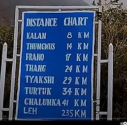
หมู่บ้าน Frano ในBaltistanและThang ใน Ladakhเป็นหมู่บ้านแฝดที่มีครอบครัวถือครองทรัพย์สินและบ้านเรือนทั้งสองฝั่ง หลังจากสงครามอินโด-ปากีสถานในปี 1971หมู่บ้านทั้งสองถูกตัดขาดจากกัน[ 3 ]
ภูมิศาสตร์
ในด้านการบริหาร ฟราโนเป็นหนึ่งในสองสภาสหภาพที่ดูแลหมู่บ้านหรือชุมชนเพิ่มเติมในหุบเขาชย็อคอีกแห่งหนึ่งคือซิกซาชุมชนที่อยู่ภายใต้สภาสหภาพ ฟราโน ได้แก่:
- มาร์ชา
- ปาร์ตุค
- เซียรี
- ทองมุส
การศึกษาและสุขภาพ
หมู่บ้านนี้มีโรงเรียนประถมศึกษาที่ดำเนินการโดยรัฐ 2 แห่ง และโรงเรียนมัธยม 1 แห่ง[ 4 ]โรงเรียนแห่งแรกก่อตั้งขึ้นในปี 1953 ตามมาด้วยโรงเรียนประถมศึกษาอีกแห่งในปี 1995 และในปี 2011 ก็มีการก่อตั้งโรงเรียนประถมศึกษาสำหรับเด็กหญิงขึ้นด้วย[ 5 ]
ฟราโนมีสถานีอนามัย ท้องถิ่น ในขณะที่โรงพยาบาล ที่ใกล้ที่สุด ตั้งอยู่ในซิกซา[ 5 ] [ 6 ]
ดูเพิ่มเติม
หมายเหตุ
- ↑หมู่บ้านนี้เป็นที่รู้จักกันทั่วไปในชื่อ " Pharnu " หรือ " Prahnu " ข้ามแนวชายแดน ซึ่งเป็นการเพี้ยนมาจากการถอดเสียงหรือการออกเสียงภาษาอูร์ดู