
Moose Falls
Coordinates: 44°09′08″N110°40′20″W / 44.15222°N 110.67222°W / 44.15222; -110.67222 (Moose Falls)
Moose Falls (height 30 feet (9.1 m)) is a plunge type waterfall on Crawfish Creek in Yellowstone National Park. The waterfall was named in 1885 by members of the Arnold Hague Geologic Survey for the plentiful moose found in the southern sections of the park.[2] The falls are just 75 yards (69 m) west of south entrance road via an easy trail that begins 1.2 miles (1.9 km) north of the south entrance station.
Climate
There is climate data for the nearby Snake River Station. Moose Falls has a subarctic climate (KöppenDfc).
| Climate data for Snake River, Wyoming, 1991–2020 normals, 1905–2020 extremes: 6882ft (2098m) | |||||||||||||
|---|---|---|---|---|---|---|---|---|---|---|---|---|---|
| Month | Jan | Feb | Mar | Apr | May | Jun | Jul | Aug | Sep | Oct | Nov | Dec | Year |
| Record high °F (°C) | 51(11) | 57(14) | 62(17) | 74(23) | 83(28) | 92(33) | 97(36) | 94(34) | 90(32) | 83(28) | 64(18) | 51(11) | 97(36) |
| Mean maximum °F (°C) | 38.9(3.8) | 43.9(6.6) | 53.4(11.9) | 62.2(16.8) | 72.5(22.5) | 81.2(27.3) | 86.6(30.3) | 86.2(30.1) | 81.0(27.2) | 69.4(20.8) | 51.9(11.1) | 39.4(4.1) | 87.7(30.9) |
| Mean daily maximum °F (°C) | 26.0(−3.3) | 30.1(−1.1) | 38.8(3.8) | 45.5(7.5) | 56.4(13.6) | 66.4(19.1) | 76.9(24.9) | 76.3(24.6) | 66.0(18.9) | 50.7(10.4) | 35.3(1.8) | 25.4(−3.7) | 49.5(9.7) |
| Daily mean °F (°C) | 13.3(−10.4) | 16.4(−8.7) | 24.9(−3.9) | 32.9(0.5) | 42.2(5.7) | 50.3(10.2) | 57.4(14.1) | 55.7(13.2) | 47.0(8.3) | 35.8(2.1) | 23.1(−4.9) | 13.5(−10.3) | 34.4(1.3) |
| Mean daily minimum °F (°C) | 0.6(−17.4) | 2.7(−16.3) | 11.0(−11.7) | 20.4(−6.4) | 28.0 (−2.2) | 34.2 (1.2) | 37.9 (3.3) | 35.1 (1.7) | 28.0 (−2.2) | 20.8 (−6.2) | 10.8 (−11.8) | 1.6 (−16.9) | 19.3 (−7.1) |
| ค่าเฉลี่ยต่ำสุด °F (°C) | −25.9 (−32.2) | −23.5 (−30.8) | −14.7 (−25.9) | 3.6 (−15.8) | 15.3 (−9.3) | 24.8 (−4.0) | 28.5 (−1.9) | 25.3 (−3.7) | 17.7 (−7.9) | 6.0 (−14.4) | −12.2 (−24.6) | −25.1 (−31.7) | −30.5 (−34.7) |
| บันทึกอุณหภูมิต่ำสุด °F (°C) | −47 (−44) | −56 (−49) | −50 (−46) | −22 (−30) | 0 (−18) | 16 (−9) | 20 (−7) | 12 (−11) | 2 (−17) | −22 (−30) | −38 (−39) | −47 (−44) | −56 (−49) |
| ปริมาณ น้ำฝนเฉลี่ย(มม.) | 3.88 (99) | 3.07 (78) | 3.02 (77) | 2.81 (71) | 2.78 (71) | 2.44 (62) | 1.41 (36) | 1.60 (41) | 1.87 (47) | 2.27 (58) | 3.46 (88) | 4.21 (107) | 32.82 (835) |
| ปริมาณหิมะเฉลี่ย (นิ้ว/ซม.) | 65.00 (165.1) | 50.20 (127.5) | 31.00 (78.7) | 25.90 (65.8) | 5.00 (12.7) | 0.30 (0.76) | 0.00 (0.00) | 0.00 (0.00) | 0.20 (0.51) | 8.90 (22.6) | 42.40 (107.7) | 64.70 (164.3) | 293.6 (745.67) |
| ความลึกของหิมะสูงสุดโดยเฉลี่ย (นิ้ว/ซม.) | 52.9 (134) | 60.9 (155) | 62.4 (158) | 50.5 (128) | 22.8 (58) | 0.9 (2.3) | 0.0 (0.0) | 0.0 (0.0) | 0.1 (0.25) | 5.7 (14) | 15.9 (40) | 39.1 (99) | 65.2 (166) |
| จำนวนวันที่มีฝนตกโดยเฉลี่ย(≥ 0.01 นิ้ว) | 18.0 | 16.0 | 14.8 | 14.8 | 12.5 | 12.7 | 9.0 | 9.2 | 8.7 | 10.2 | 14.9 | 19.6 | 160.4 |
| จำนวนวันที่มีหิมะตกโดยเฉลี่ย(≥ 0.1 นิ้ว) | 17.6 | 15.7 | 12.5 | 8.6 | 3.0 | 0.3 | 0.0 | 0.0 | 0.4 | 4.3 | 11.5 | 18.2 | 92.1 |
| แหล่งที่มา 1: NOAA [ 3 ] | |||||||||||||
| แหล่งที่มา 2: XMACIS2 (บันทึก, อุณหภูมิสูงสุด/ต่ำสุดรายเดือนและความลึกของหิมะ ตั้งแต่ปี 1991-2020) [ 4 ] | |||||||||||||
แกลเลอรี่
ภาพถ่ายเมืองมูสฟอลส์
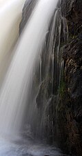 ภาพระยะใกล้ของน้ำตกมูสฟอลส์
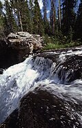 บริงค์, 1977
ดูเพิ่มเติม
หมายเหตุ
- ↑ "น้ำตกมูส"ระบบข้อมูลชื่อทางภูมิศาสตร์สำนักงานสำรวจทางธรณีวิทยาแห่งสหรัฐอเมริกา กระทรวง มหาดไทยแห่งสหรัฐอเมริกา
- ↑ Whittlesey, Lee (1996). Yellowstone Place Names . Gardiner, MT: Wonderland Publishing Company. หน้า174. ISBN 1-59971-716-6.
- ↑ "Snake RVR, Wyoming 1991-2020 ค่าเฉลี่ยรายเดือน" สืบค้นเมื่อ 14 ตุลาคม 2023
- ↑ "xmACIS" . สำนักงานบริหารมหาสมุทรและบรรยากาศแห่งชาติ. สืบค้นเมื่อ19 กุมภาพันธ์ 2024 .