
นิวเกต เชสเตอร์


[[Bonewaldesthorne's Tower]]
[[File:Bonewaldesthorne's Tower.jpg|250px]]\", \"description\": \" ([https://geohack.toolforge.org/geohack.php?params=53.19267;-2.89892_dim:2000 53.19267,-2.89892])\", \"marker-symbol\": \"-number-F502948\", \"marker-size\": \"medium\", \"marker-color\": \"#1c559e\" }, \"geometry\": {\"type\": \"Point\", \"coordinates\": [-2.89892,53.19267] } }, { \"type\": \"Feature\", \"properties\": { \"title\": \"2
Spur Wall and [[Water Tower, Chester|Water Tower]]
[[File:Chester Water Tower 2.jpg|250px]]\", \"description\": \"The Water Tower is outside the northwest corner of the walls, and is joined to Bonewaldesthorne's Tower by a spur wall. ([https://geohack.toolforge.org/geohack.php?params=53.19257;-2.89957_dim:2000 53.19257,-2.89957])\", \"marker-symbol\": \"-number-F502948\", \"marker-size\": \"medium\", \"marker-color\": \"#1c559e\" }, \"geometry\": {\"type\": \"Point\", \"coordinates\": [-2.89957,53.19257] } }, { \"type\": \"Feature\", \"properties\": { \"title\": \"3
Wall between Bonewaldesthorne's Tower and Pemberton's Parlour
[[File:The city walls over the railway - geograph.org.uk - 632785.jpg|250px]]\", \"description\": \" ([https://geohack.toolforge.org/geohack.php?params=53.19288;-2.8978_dim:2000 53.19288,-2.8978])\", \"marker-symbol\": \"-number-F502948\", \"marker-size\": \"medium\", \"marker-color\": \"#1c559e\" }, \"geometry\": {\"type\": \"Point\", \"coordinates\": [-2.8978,53.19288] } }, { \"type\": \"Feature\", \"properties\": { \"title\": \"4
[[Pemberton's Parlour]]
[[File:Goblin Tower on the City Walls - geograph.org.uk - 562240.jpg|250px]]\", \"description\": \" ([https://geohack.toolforge.org/geohack.php?params=53.193;-2.89723_dim:2000 53.193,-2.89723])\", \"marker-symbol\": \"-number-F502948\", \"marker-size\": \"medium\", \"marker-color\": \"#1c559e\" }, \"geometry\": {\"type\": \"Point\", \"coordinates\": [-2.89723,53.193] } }, { \"type\": \"Feature\", \"properties\": { \"title\": \"5
Wall between Pemberton's Parlour and St Martin's Gate
[[File:Chester City Walls on the appropriately named City Wall Street (geograph 4875174).jpg|250px]]\", \"description\": \" ([https://geohack.toolforge.org/geohack.php?params=53.19307;-2.89684_dim:2000 53.19307,-2.89684])\", \"marker-symbol\": \"-number-F502948\", \"marker-size\": \"medium\", \"marker-color\": \"#1c559e\" }, \"geometry\": {\"type\": \"Point\", \"coordinates\": [-2.89684,53.19307] } }, { \"type\": \"Feature\", \"properties\": { \"title\": \"6
St Martin's Gate
[[File:St Martin's Gate, Chester (geograph 4381912).jpg|250px]]\", \"description\": \" ([https://geohack.toolforge.org/geohack.php?params=53.19319;-2.89633_dim:2000 53.19319,-2.89633])\", \"marker-symbol\": \"-number-F502948\", \"marker-size\": \"medium\", \"marker-color\": \"#1c559e\" }, \"geometry\": {\"type\": \"Point\", \"coordinates\": [-2.89633,53.19319] } }, { \"type\": \"Feature\", \"properties\": { \"title\": \"7
Wall between St Martin's Gate and Morgan's Mount
[[File:Water Tower Street and a bench mark (geograph 4699846).jpg|250px]]\", \"description\": \" ([https://geohack.toolforge.org/geohack.php?params=53.19319;-2.89603_dim:2000 53.19319,-2.89603])\", \"marker-symbol\": \"-number-F502948\", \"marker-size\": \"medium\", \"marker-color\": \"#1c559e\" }, \"geometry\": {\"type\": \"Point\", \"coordinates\": [-2.89603,53.19319] } }, { \"type\": \"Feature\", \"properties\": { \"title\": \"8
[[Morgan's Mount]]
[[File:Morgan's Mount on the city walls - geograph.org.uk - 694425.jpg|250px]]\", \"description\": \" ([https://geohack.toolforge.org/geohack.php?params=53.19328;-2.89588_dim:2000 53.19328,-2.89588])\", \"marker-symbol\": \"-number-F502948\", \"marker-size\": \"medium\", \"marker-color\": \"#1c559e\" }, \"geometry\": {\"type\": \"Point\", \"coordinates\": [-2.89588,53.19328] } }, { \"type\": \"Feature\", \"properties\": { \"title\": \"9
Wall between Morgan's Mount and Northgate
[[File:Chester City Walls (geograph 4382189).jpg|250px]]\", \"description\": \" ([https://geohack.toolforge.org/geohack.php?params=53.19351;-2.89474_dim:2000 53.19351,-2.89474])\", \"marker-symbol\": \"-number-F502948\", \"marker-size\": \"medium\", \"marker-color\": \"#1c559e\" }, \"geometry\": {\"type\": \"Point\", \"coordinates\": [-2.89474,53.19351] } }, { \"type\": \"Feature\", \"properties\": { \"title\": \"10
[[Northgate, Chester|Northgate]]
[[File:Northgate, Chester.jpg|250px]]\", \"description\": \" ([https://geohack.toolforge.org/geohack.php?params=53.1938;-2.89333_dim:2000 53.1938,-2.89333])\", \"marker-symbol\": \"-number-F502948\", \"marker-size\": \"medium\", \"marker-color\": \"#1c559e\" }, \"geometry\": {\"type\": \"Point\", \"coordinates\": [-2.89333,53.1938] } }, { \"type\": \"Feature\", \"properties\": { \"title\": \"11
Wall between Northgate and Phoenix Tower
[[File:Chester city wall and Shropshire Union Canal - geograph.org.uk - 1128122.jpg|250px]]\", \"description\": \" ([https://geohack.toolforge.org/geohack.php?params=53.1941;-2.89153_dim:2000 53.1941,-2.89153])\", \"marker-symbol\": \"-number-F502948\", \"marker-size\": \"medium\", \"marker-color\": \"#1c559e\" }, \"geometry\": {\"type\": \"Point\", \"coordinates\": [-2.89153,53.1941] } }, { \"type\": \"Feature\", \"properties\": { \"title\": \"12
[[Phoenix Tower, Chester|Phoenix Tower]]
[[File:King Charles Tower, City Walls, Chester - geograph.org.uk - 9695.jpg|250px]]\", \"description\": \" ([https://geohack.toolforge.org/geohack.php?params=53.19416;-2.89041_dim:2000 53.19416,-2.89041])\", \"marker-symbol\": \"-number-F502948\", \"marker-size\": \"medium\", \"marker-color\": \"#1c559e\" }, \"geometry\": {\"type\": \"Point\", \"coordinates\": [-2.89041,53.19416] } }, { \"type\": \"Feature\", \"properties\": { \"title\": \"13
Wall between Phoenix Tower and Kaleyard Gate
[[File:Chester City Wall (geograph 3656923).jpg|250px]]\", \"description\": \" ([https://geohack.toolforge.org/geohack.php?params=53.19363;-2.89014_dim:2000 53.19363,-2.89014])\", \"marker-symbol\": \"-number-F502948\", \"marker-size\": \"medium\", \"marker-color\": \"#1c559e\" }, \"geometry\": {\"type\": \"Point\", \"coordinates\": [-2.89014,53.19363] } }, { \"type\": \"Feature\", \"properties\": { \"title\": \"14
[[Kaleyard Gate, Chester|Kaleyard Gate]]
[[File:Kaleyard Gate 1.jpg|250px]]\", \"description\": \" ([https://geohack.toolforge.org/geohack.php?params=53.1926;-2.88963_dim:2000 53.1926,-2.88963])\", \"marker-symbol\": \"-number-F502948\", \"marker-size\": \"medium\", \"marker-color\": \"#1c559e\" }, \"geometry\": {\"type\": \"Point\", \"coordinates\": [-2.88963,53.1926] } }, { \"type\": \"Feature\", \"properties\": { \"title\": \"15
Wall between Kaleyard Gate and Eastgate
[[File:City walls and blocked doorway - geograph.org.uk - 667897.jpg|250px]]\", \"description\": \" ([https://geohack.toolforge.org/geohack.php?params=53.1914;-2.88907_dim:2000 53.1914,-2.88907])\", \"marker-symbol\": \"-number-F502948\", \"marker-size\": \"medium\", \"marker-color\": \"#1c559e\" }, \"geometry\": {\"type\": \"Point\", \"coordinates\": [-2.88907,53.1914] } }, { \"type\": \"Feature\", \"properties\": { \"title\": \"16
[[Eastgate, Chester|Eastgate]]
[[File:Eastgate.jpg|250px]]\", \"description\": \" ([https://geohack.toolforge.org/geohack.php?params=53.19087;-2.8888_dim:2000 53.19087,-2.8888])\", \"marker-symbol\": \"-number-F502948\", \"marker-size\": \"medium\", \"marker-color\": \"#1c559e\" }, \"geometry\": {\"type\": \"Point\", \"coordinates\": [-2.8888,53.19087] } }, { \"type\": \"Feature\", \"properties\": { \"title\": \"17
Wall between Eastgate and Thimbleby's Tower
[[File:A view along Chester's Walls - geograph.org.uk - 12054.jpg|250px]]\", \"description\": \" ([https://geohack.toolforge.org/geohack.php?params=53.18998;-2.88845_dim:2000 53.18998,-2.88845])\", \"marker-symbol\": \"-number-F502948\", \"marker-size\": \"medium\", \"marker-color\": \"#1c559e\" }, \"geometry\": {\"type\": \"Point\", \"coordinates\": [-2.88845,53.18998] } }, { \"type\": \"Feature\", \"properties\": { \"title\": \"18
[[Thimbleby's Tower]]
[[File:Thimbleby's Tower.jpg|250px]]\", \"description\": \" ([https://geohack.toolforge.org/geohack.php?params=53.1894;-2.88816_dim:2000 53.1894,-2.88816])\", \"marker-symbol\": \"-number-F502948\", \"marker-size\": \"medium\", \"marker-color\": \"#1c559e\" }, \"geometry\": {\"type\": \"Point\", \"coordinates\": [-2.88816,53.1894] } }, { \"type\": \"Feature\", \"properties\": { \"title\": \"19
Wall between Thimbleby's Tower and Old Newgate
[[File:Chester City Walls - geograph.org.uk - 1152340.jpg|250px]]\", \"description\": \" ([https://geohack.toolforge.org/geohack.php?params=53.18927;-2.88822_dim:2000 53.18927,-2.88822])\", \"marker-symbol\": \"-number-F502948\", \"marker-size\": \"medium\", \"marker-color\": \"#1c559e\" }, \"geometry\": {\"type\": \"Point\", \"coordinates\": [-2.88822,53.18927] } }, { \"type\": \"Feature\", \"properties\": { \"title\": \"20
Old Newgate
[[File:Old Newgate, Chester.jpg|250px]]\", \"description\": \" ([https://geohack.toolforge.org/geohack.php?params=53.18918;-2.88831_dim:2000 53.18918,-2.88831])\", \"marker-symbol\": \"-number-F502948\", \"marker-size\": \"medium\", \"marker-color\": \"#1c559e\" }, \"geometry\": {\"type\": \"Point\", \"coordinates\": [-2.88831,53.18918] } }, { \"type\": \"Feature\", \"properties\": { \"title\": \"21
[[Newgate, Chester|Newgate]]
[[File:Newgate, Chester.jpg|250px]]\", \"description\": \" ([https://geohack.toolforge.org/geohack.php?params=53.18902;-2.88819_dim:2000 53.18902,-2.88819])\", \"marker-symbol\": \"-number-F502948\", \"marker-size\": \"medium\", \"marker-color\": \"#1c559e\" }, \"geometry\": {\"type\": \"Point\", \"coordinates\": [-2.88819,53.18902] } }, { \"type\": \"Feature\", \"properties\": { \"title\": \"22
Wall between Newgate and Barnaby's Tower
[[File:Chester's City Walls - Bridgegate to Eastgate ^10 - geograph.org.uk - 375008.jpg|250px]]\", \"description\": \" ([https://geohack.toolforge.org/geohack.php?params=53.1886;-2.88797_dim:2000 53.1886,-2.88797])\", \"marker-symbol\": \"-number-F502948\", \"marker-size\": \"medium\", \"marker-color\": \"#1c559e\" }, \"geometry\": {\"type\": \"Point\", \"coordinates\": [-2.88797,53.1886] } }, { \"type\": \"Feature\", \"properties\": { \"title\": \"23
[[Barnaby's Tower]]
[[File:BarnabysTower.JPG|250px]]\", \"description\": \" ([https://geohack.toolforge.org/geohack.php?params=53.18763;-2.8875_dim:2000 53.18763,-2.8875])\", \"marker-symbol\": \"-number-F502948\", \"marker-size\": \"medium\", \"marker-color\": \"#1c559e\" }, \"geometry\": {\"type\": \"Point\", \"coordinates\": [-2.8875,53.18763] } }, { \"type\": \"Feature\", \"properties\": { \"title\": \"24
Wall between Barnaby's Tower and the Drum Tower
[[File:The walls, Chester - geograph.org.uk - 215859.jpg|250px]]\", \"description\": \" ([https://geohack.toolforge.org/geohack.php?params=53.18712;-2.88781_dim:2000 53.18712,-2.88781])\", \"marker-symbol\": \"-number-F502948\", \"marker-size\": \"medium\", \"marker-color\": \"#1c559e\" }, \"geometry\": {\"type\": \"Point\", \"coordinates\": [-2.88781,53.18712] } }, { \"type\": \"Feature\", \"properties\": { \"title\": \"25
[[Recorder's Steps]]
[[File:Recorder's Steps.jpg|250px]]\", \"description\": \" ([https://geohack.toolforge.org/geohack.php?params=53.18733;-2.88746_dim:2000 53.18733,-2.88746])\", \"marker-symbol\": \"-number-F502948\", \"marker-size\": \"medium\", \"marker-color\": \"#1c559e\" }, \"geometry\": {\"type\": \"Point\", \"coordinates\": [-2.88746,53.18733] } }, { \"type\": \"Feature\", \"properties\": { \"title\": \"26
Drum Tower
[[File:Drum Tower (cropped).jpg|250px]]\", \"description\": \" ([https://geohack.toolforge.org/geohack.php?params=53.18637;-2.88869_dim:2000 53.18637,-2.88869])\", \"marker-symbol\": \"-number-F502948\", \"marker-size\": \"medium\", \"marker-color\": \"#1c559e\" }, \"geometry\": {\"type\": \"Point\", \"coordinates\": [-2.88869,53.18637] } }, { \"type\": \"Feature\", \"properties\": { \"title\": \"27
Wall between the Drum Tower and Bridgegate
[[File:River Dee and City Wall, Chester - geograph.org.uk - 3227693.jpg|250px]]\", \"description\": \" ([https://geohack.toolforge.org/geohack.php?params=53.18629;-2.88896_dim:2000 53.18629,-2.88896])\", \"marker-symbol\": \"-number-F502948\", \"marker-size\": \"medium\", \"marker-color\": \"#1c559e\" }, \"geometry\": {\"type\": \"Point\", \"coordinates\": [-2.88896,53.18629] } }, { \"type\": \"Feature\", \"properties\": { \"title\": \"28
[[Bridgegate, Chester|Bridgegate]]
[[File:Bridgegate.jpg|250px]]\", \"description\": \" ([https://geohack.toolforge.org/geohack.php?params=53.18621;-2.88928_dim:2000 53.18621,-2.88928])\", \"marker-symbol\": \"-number-F502948\", \"marker-size\": \"medium\", \"marker-color\": \"#1c559e\" }, \"geometry\": {\"type\": \"Point\", \"coordinates\": [-2.88928,53.18621] } }, { \"type\": \"Feature\", \"properties\": { \"title\": \"29
Wall between Bridgegate and the former County Hall
[[File:Chester's City Walls - Grosvenor Road to Bridgegate ^13 - geograph.org.uk - 370045.jpg|250px]]\", \"description\": \" ([https://geohack.toolforge.org/geohack.php?params=53.18606;-2.8897_dim:2000 53.18606,-2.8897])\", \"marker-symbol\": \"-number-F502948\", \"marker-size\": \"medium\", \"marker-color\": \"#1c559e\" }, \"geometry\": {\"type\": \"Point\", \"coordinates\": [-2.8897,53.18606] } }, { \"type\": \"Feature\", \"properties\": { \"title\": \"30
Wall between former County Hall and Grosvenor Road
[[File:Chester's City Walls - Grosvenor Road to Bridgegate ^5 - geograph.org.uk - 368978.jpg|250px]]\", \"description\": \" ([https://geohack.toolforge.org/geohack.php?params=53.18496;-2.89345_dim:2000 53.18496,-2.89345])\", \"marker-symbol\": \"-number-F502948\", \"marker-size\": \"medium\", \"marker-color\": \"#1c559e\" }, \"geometry\": {\"type\": \"Point\", \"coordinates\": [-2.89345,53.18496] } }, { \"type\": \"Feature\", \"properties\": { \"title\": \"31
Wall between Grosvenor Road and Watergate
[[File:Chester racecourse - geograph.org.uk - 641229.jpg|250px]]\", \"description\": \" ([https://geohack.toolforge.org/geohack.php?params=53.18714;-2.89599_dim:2000 53.18714,-2.89599])\", \"marker-symbol\": \"-number-F502948\", \"marker-size\": \"medium\", \"marker-color\": \"#1c559e\" }, \"geometry\": {\"type\": \"Point\", \"coordinates\": [-2.89599,53.18714] } }, { \"type\": \"Feature\", \"properties\": { \"title\": \"32
[[Watergate, Chester|Watergate]]
[[File:Watergate, Chester.jpg|250px]]\", \"description\": \" ([https://geohack.toolforge.org/geohack.php?params=53.18936;-2.89739_dim:2000 53.18936,-2.89739])\", \"marker-symbol\": \"-number-F502948\", \"marker-size\": \"medium\", \"marker-color\": \"#1c559e\" }, \"geometry\": {\"type\": \"Point\", \"coordinates\": [-2.89739,53.18936] } }, { \"type\": \"Feature\", \"properties\": { \"title\": \"33
Wall between Watergate and Bonewaldesthorne's Tower
[[File:Chester City Walls from City Walls Road - geograph.org.uk - 450410.jpg|250px]]\", \"description\": \" ([https://geohack.toolforge.org/geohack.php?params=53.19086;-2.89793_dim:2000 53.19086,-2.89793])\", \"marker-symbol\": \"-number-F502948\", \"marker-size\": \"medium\", \"marker-color\": \"#1c559e\" }, \"geometry\": {\"type\": \"Point\", \"coordinates\": [-2.89793,53.19086] } }, { \"type\": \"Feature\", \"properties\": { \"title\": \"[[Chester Amphitheatre]]
\", \"description\": \" ([https://geohack.toolforge.org/geohack.php?params=53.1892;-2.887_dim:2000 53.1892,-2.887])\", \"marker-symbol\": \"-number-F502948\", \"marker-size\": \"medium\", \"marker-color\": \"#444433\" }, \"geometry\": {\"type\": \"Point\", \"coordinates\": [-2.887,53.1892] } }, { \"type\": \"Feature\", \"properties\": { \"title\": \"[[Chester Castle]]
[[File:Chester Castle - geograph.org.uk - 7346747.jpg|250px]]\", \"description\": \" ([https://geohack.toolforge.org/geohack.php?params=53.18529;-2.89261_dim:2000 53.18529,-2.89261])\", \"marker-symbol\": \"-number-F502948\", \"marker-size\": \"medium\", \"marker-color\": \"#777755\" }, \"geometry\": {\"type\": \"Point\", \"coordinates\": [-2.89261,53.18529] } }, { \"type\": \"Feature\", \"properties\": { \"title\": \"[[Chester Cathedral]]
[[File:Chester Cathedral ext Hamilton 005.JPG|250px]]\", \"description\": \" ([https://geohack.toolforge.org/geohack.php?params=53.1919;-2.8905_dim:2000 53.1919,-2.8905])\", \"marker-symbol\": \"-number-F502948\", \"marker-size\": \"medium\", \"marker-color\": \"#777755\" }, \"geometry\": {\"type\": \"Point\", \"coordinates\": [-2.8905,53.1919] } }, { \"type\": \"Feature\", \"properties\": { \"title\": \"\", \"description\": \" ([https://geohack.toolforge.org/geohack.php?params=1;1_dim:2000 1,1])\", \"marker-symbol\": \"-number-F502948\", \"marker-size\": \"medium\", \"marker-color\": \"#444433\" }, \"geometry\": {\"type\": \"Point\", \"coordinates\": [1,1] } } ] } ]"}}">
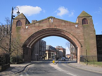
สะพานนิวเกตเป็นสะพานโค้งที่รองรับทางเดินของกำแพงเมืองเหนือถนนเปปเปอร์ในเชสเตอร์เชสเชอร์ประเทศอังกฤษ ได้รับการขึ้นทะเบียนในรายชื่อมรดกแห่งชาติของอังกฤษ ในฐานะ อาคารอนุรักษ์ระดับ2 [ 2 ] สะพาน นี้สร้างขึ้นในปี 1937–38 เพื่อบรรเทาปัญหาการจราจรติดขัดในเมือง โดยเฉพาะที่เชสเตอร์ครอสซึ่งเกี่ยวข้องกับการเจาะช่องใหม่ในกำแพงเมือง[ 3 ]
สะพานสร้างด้วยหินทราย สีแดง ออกแบบโดยเซอร์วอลเตอร์ แทปเปอร์และไมเคิล บุตรชายของเขา ด้านข้างสะพานแต่ละด้านมีหอคอยที่มีช่องหน้าต่างจำลอง (หน้าต่างแคบๆ ที่ไม่มีกระจก) และมีหลังคาทรงปั้นหยาบันไดหลายขั้นอยู่ด้านข้างแต่ละด้านนำไปสู่หอคอยและทางเดินบนยอดสะพาน โครงสร้างตกแต่งด้วยโล่แกะสลักและดอกกุหลาบทิวดอร์ [ 2 ] นัก ประวัติศาสตร์ไซมอน วอร์ด แสดงความคิดเห็นว่า "การออกแบบสอดคล้องกับ ความรู้สึก แบบยุคกลาง โดยทั่วไป ของกำแพง" [ 3 ]