
อีสต์เกต เชสเตอร์

ประตูอีสต์เกตเป็นประตูที่เปิดตลอดเวลาซึ่งเป็นส่วน หนึ่งของ กำแพงเมืองเชสเตอร์ตั้งอยู่บนพื้นที่ซึ่งเคยเป็นทางเข้าป้อมปราการโรมันเดวา วิคทริกซ์ใน เมือง เชสเตอร์ มณฑลเชสเชอร์ประเทศอังกฤษ ประตูแห่งนี้เป็นแลนด์มาร์คที่โดดเด่นของเมืองเชสเตอร์ และนาฬิกาอีสต์เกตที่อยู่ด้านบนนั้นว่ากันว่าเป็นนาฬิกาที่ถูกถ่ายรูปมากที่สุดในอังกฤษรองจากบิ๊กเบน
ประตูเดิมมีหอคอยไม้คอยเฝ้า ซึ่งต่อมาถูกแทนที่ด้วยหอคอยหินในศตวรรษที่ 2 และหอคอยหินนี้ก็ถูกแทนที่อีกครั้งในศตวรรษที่ 14 ประตูเมืองปัจจุบันสร้างขึ้นในปี 1768 เป็น โครงสร้าง หินทราย สามโค้ง ซึ่งเป็นส่วนหนึ่งของกำแพงเมืองเชสเตอร์ในปี 1899 ได้มีการเพิ่มนาฬิกาไว้ด้านบนของประตูเมืองเพื่อเฉลิมฉลองวาระครบรอบ 60 ปีแห่งการครองราชย์ของสมเด็จพระราชินีนาถวิกตอเรียเมื่อสองปีก่อนหน้านั้น นาฬิกาตั้งอยู่บน เสาเหล็ก ฉลุลายมีหน้าปัดนาฬิกาอยู่ทั้งสี่ด้าน และมีโดม ทองแดงรูปทรง โค้ง นาฬิกาได้รับการออกแบบโดยจอห์น ดักลาส สถาปนิกของเชสเตอร์ โครงสร้างทั้งหมด ทั้งประตูเมืองและนาฬิกา ได้รับการขึ้นทะเบียนเป็นอาคารอนุรักษ์ ระดับ 1 เมื่อวันที่ 28 กรกฎาคม 1955 [ 1 ]
อีสต์เกต
ประวัติศาสตร์


[[Bonewaldesthorne's Tower]]
[[File:Bonewaldesthorne's Tower.jpg|250px]]\", \"description\": \" ([https://geohack.toolforge.org/geohack.php?params=53.19267;-2.89892_dim:2000 53.19267,-2.89892])\", \"marker-symbol\": \"-number-F502948\", \"marker-size\": \"medium\", \"marker-color\": \"#1c559e\" }, \"geometry\": {\"type\": \"Point\", \"coordinates\": [-2.89892,53.19267] } }, { \"type\": \"Feature\", \"properties\": { \"title\": \"2
Spur Wall and [[Water Tower, Chester|Water Tower]]
[[File:Chester Water Tower 2.jpg|250px]]\", \"description\": \"The Water Tower is outside the northwest corner of the walls, and is joined to Bonewaldesthorne's Tower by a spur wall. ([https://geohack.toolforge.org/geohack.php?params=53.19257;-2.89957_dim:2000 53.19257,-2.89957])\", \"marker-symbol\": \"-number-F502948\", \"marker-size\": \"medium\", \"marker-color\": \"#1c559e\" }, \"geometry\": {\"type\": \"Point\", \"coordinates\": [-2.89957,53.19257] } }, { \"type\": \"Feature\", \"properties\": { \"title\": \"3
Wall between Bonewaldesthorne's Tower and Pemberton's Parlour
[[File:The city walls over the railway - geograph.org.uk - 632785.jpg|250px]]\", \"description\": \" ([https://geohack.toolforge.org/geohack.php?params=53.19288;-2.8978_dim:2000 53.19288,-2.8978])\", \"marker-symbol\": \"-number-F502948\", \"marker-size\": \"medium\", \"marker-color\": \"#1c559e\" }, \"geometry\": {\"type\": \"Point\", \"coordinates\": [-2.8978,53.19288] } }, { \"type\": \"Feature\", \"properties\": { \"title\": \"4
[[Pemberton's Parlour]]
[[File:Goblin Tower on the City Walls - geograph.org.uk - 562240.jpg|250px]]\", \"description\": \" ([https://geohack.toolforge.org/geohack.php?params=53.193;-2.89723_dim:2000 53.193,-2.89723])\", \"marker-symbol\": \"-number-F502948\", \"marker-size\": \"medium\", \"marker-color\": \"#1c559e\" }, \"geometry\": {\"type\": \"Point\", \"coordinates\": [-2.89723,53.193] } }, { \"type\": \"Feature\", \"properties\": { \"title\": \"5
Wall between Pemberton's Parlour and St Martin's Gate
[[File:Chester City Walls on the appropriately named City Wall Street (geograph 4875174).jpg|250px]]\", \"description\": \" ([https://geohack.toolforge.org/geohack.php?params=53.19307;-2.89684_dim:2000 53.19307,-2.89684])\", \"marker-symbol\": \"-number-F502948\", \"marker-size\": \"medium\", \"marker-color\": \"#1c559e\" }, \"geometry\": {\"type\": \"Point\", \"coordinates\": [-2.89684,53.19307] } }, { \"type\": \"Feature\", \"properties\": { \"title\": \"6
St Martin's Gate
[[File:St Martin's Gate, Chester (geograph 4381912).jpg|250px]]\", \"description\": \" ([https://geohack.toolforge.org/geohack.php?params=53.19319;-2.89633_dim:2000 53.19319,-2.89633])\", \"marker-symbol\": \"-number-F502948\", \"marker-size\": \"medium\", \"marker-color\": \"#1c559e\" }, \"geometry\": {\"type\": \"Point\", \"coordinates\": [-2.89633,53.19319] } }, { \"type\": \"Feature\", \"properties\": { \"title\": \"7
Wall between St Martin's Gate and Morgan's Mount
[[File:Water Tower Street and a bench mark (geograph 4699846).jpg|250px]]\", \"description\": \" ([https://geohack.toolforge.org/geohack.php?params=53.19319;-2.89603_dim:2000 53.19319,-2.89603])\", \"marker-symbol\": \"-number-F502948\", \"marker-size\": \"medium\", \"marker-color\": \"#1c559e\" }, \"geometry\": {\"type\": \"Point\", \"coordinates\": [-2.89603,53.19319] } }, { \"type\": \"Feature\", \"properties\": { \"title\": \"8
[[Morgan's Mount]]
[[File:Morgan's Mount on the city walls - geograph.org.uk - 694425.jpg|250px]]\", \"description\": \" ([https://geohack.toolforge.org/geohack.php?params=53.19328;-2.89588_dim:2000 53.19328,-2.89588])\", \"marker-symbol\": \"-number-F502948\", \"marker-size\": \"medium\", \"marker-color\": \"#1c559e\" }, \"geometry\": {\"type\": \"Point\", \"coordinates\": [-2.89588,53.19328] } }, { \"type\": \"Feature\", \"properties\": { \"title\": \"9
Wall between Morgan's Mount and Northgate
[[File:Chester City Walls (geograph 4382189).jpg|250px]]\", \"description\": \" ([https://geohack.toolforge.org/geohack.php?params=53.19351;-2.89474_dim:2000 53.19351,-2.89474])\", \"marker-symbol\": \"-number-F502948\", \"marker-size\": \"medium\", \"marker-color\": \"#1c559e\" }, \"geometry\": {\"type\": \"Point\", \"coordinates\": [-2.89474,53.19351] } }, { \"type\": \"Feature\", \"properties\": { \"title\": \"10
[[Northgate, Chester|Northgate]]
[[File:Northgate, Chester.jpg|250px]]\", \"description\": \" ([https://geohack.toolforge.org/geohack.php?params=53.1938;-2.89333_dim:2000 53.1938,-2.89333])\", \"marker-symbol\": \"-number-F502948\", \"marker-size\": \"medium\", \"marker-color\": \"#1c559e\" }, \"geometry\": {\"type\": \"Point\", \"coordinates\": [-2.89333,53.1938] } }, { \"type\": \"Feature\", \"properties\": { \"title\": \"11
Wall between Northgate and Phoenix Tower
[[File:Chester city wall and Shropshire Union Canal - geograph.org.uk - 1128122.jpg|250px]]\", \"description\": \" ([https://geohack.toolforge.org/geohack.php?params=53.1941;-2.89153_dim:2000 53.1941,-2.89153])\", \"marker-symbol\": \"-number-F502948\", \"marker-size\": \"medium\", \"marker-color\": \"#1c559e\" }, \"geometry\": {\"type\": \"Point\", \"coordinates\": [-2.89153,53.1941] } }, { \"type\": \"Feature\", \"properties\": { \"title\": \"12
[[Phoenix Tower, Chester|Phoenix Tower]]
[[File:King Charles Tower, City Walls, Chester - geograph.org.uk - 9695.jpg|250px]]\", \"description\": \" ([https://geohack.toolforge.org/geohack.php?params=53.19416;-2.89041_dim:2000 53.19416,-2.89041])\", \"marker-symbol\": \"-number-F502948\", \"marker-size\": \"medium\", \"marker-color\": \"#1c559e\" }, \"geometry\": {\"type\": \"Point\", \"coordinates\": [-2.89041,53.19416] } }, { \"type\": \"Feature\", \"properties\": { \"title\": \"13
Wall between Phoenix Tower and Kaleyard Gate
[[File:Chester City Wall (geograph 3656923).jpg|250px]]\", \"description\": \" ([https://geohack.toolforge.org/geohack.php?params=53.19363;-2.89014_dim:2000 53.19363,-2.89014])\", \"marker-symbol\": \"-number-F502948\", \"marker-size\": \"medium\", \"marker-color\": \"#1c559e\" }, \"geometry\": {\"type\": \"Point\", \"coordinates\": [-2.89014,53.19363] } }, { \"type\": \"Feature\", \"properties\": { \"title\": \"14
[[Kaleyard Gate, Chester|Kaleyard Gate]]
[[File:Kaleyard Gate 1.jpg|250px]]\", \"description\": \" ([https://geohack.toolforge.org/geohack.php?params=53.1926;-2.88963_dim:2000 53.1926,-2.88963])\", \"marker-symbol\": \"-number-F502948\", \"marker-size\": \"medium\", \"marker-color\": \"#1c559e\" }, \"geometry\": {\"type\": \"Point\", \"coordinates\": [-2.88963,53.1926] } }, { \"type\": \"Feature\", \"properties\": { \"title\": \"15
Wall between Kaleyard Gate and Eastgate
[[File:City walls and blocked doorway - geograph.org.uk - 667897.jpg|250px]]\", \"description\": \" ([https://geohack.toolforge.org/geohack.php?params=53.1914;-2.88907_dim:2000 53.1914,-2.88907])\", \"marker-symbol\": \"-number-F502948\", \"marker-size\": \"medium\", \"marker-color\": \"#1c559e\" }, \"geometry\": {\"type\": \"Point\", \"coordinates\": [-2.88907,53.1914] } }, { \"type\": \"Feature\", \"properties\": { \"title\": \"16
[[Eastgate, Chester|Eastgate]]
[[File:Eastgate.jpg|250px]]\", \"description\": \" ([https://geohack.toolforge.org/geohack.php?params=53.19087;-2.8888_dim:2000 53.19087,-2.8888])\", \"marker-symbol\": \"-number-F502948\", \"marker-size\": \"medium\", \"marker-color\": \"#1c559e\" }, \"geometry\": {\"type\": \"Point\", \"coordinates\": [-2.8888,53.19087] } }, { \"type\": \"Feature\", \"properties\": { \"title\": \"17
Wall between Eastgate and Thimbleby's Tower
[[File:A view along Chester's Walls - geograph.org.uk - 12054.jpg|250px]]\", \"description\": \" ([https://geohack.toolforge.org/geohack.php?params=53.18998;-2.88845_dim:2000 53.18998,-2.88845])\", \"marker-symbol\": \"-number-F502948\", \"marker-size\": \"medium\", \"marker-color\": \"#1c559e\" }, \"geometry\": {\"type\": \"Point\", \"coordinates\": [-2.88845,53.18998] } }, { \"type\": \"Feature\", \"properties\": { \"title\": \"18
[[Thimbleby's Tower]]
[[File:Thimbleby's Tower.jpg|250px]]\", \"description\": \" ([https://geohack.toolforge.org/geohack.php?params=53.1894;-2.88816_dim:2000 53.1894,-2.88816])\", \"marker-symbol\": \"-number-F502948\", \"marker-size\": \"medium\", \"marker-color\": \"#1c559e\" }, \"geometry\": {\"type\": \"Point\", \"coordinates\": [-2.88816,53.1894] } }, { \"type\": \"Feature\", \"properties\": { \"title\": \"19
Wall between Thimbleby's Tower and Old Newgate
[[File:Chester City Walls - geograph.org.uk - 1152340.jpg|250px]]\", \"description\": \" ([https://geohack.toolforge.org/geohack.php?params=53.18927;-2.88822_dim:2000 53.18927,-2.88822])\", \"marker-symbol\": \"-number-F502948\", \"marker-size\": \"medium\", \"marker-color\": \"#1c559e\" }, \"geometry\": {\"type\": \"Point\", \"coordinates\": [-2.88822,53.18927] } }, { \"type\": \"Feature\", \"properties\": { \"title\": \"20
Old Newgate
[[File:Old Newgate, Chester.jpg|250px]]\", \"description\": \" ([https://geohack.toolforge.org/geohack.php?params=53.18918;-2.88831_dim:2000 53.18918,-2.88831])\", \"marker-symbol\": \"-number-F502948\", \"marker-size\": \"medium\", \"marker-color\": \"#1c559e\" }, \"geometry\": {\"type\": \"Point\", \"coordinates\": [-2.88831,53.18918] } }, { \"type\": \"Feature\", \"properties\": { \"title\": \"21
[[Newgate, Chester|Newgate]]
[[File:Newgate, Chester.jpg|250px]]\", \"description\": \" ([https://geohack.toolforge.org/geohack.php?params=53.18902;-2.88819_dim:2000 53.18902,-2.88819])\", \"marker-symbol\": \"-number-F502948\", \"marker-size\": \"medium\", \"marker-color\": \"#1c559e\" }, \"geometry\": {\"type\": \"Point\", \"coordinates\": [-2.88819,53.18902] } }, { \"type\": \"Feature\", \"properties\": { \"title\": \"22
Wall between Newgate and Barnaby's Tower
[[File:Chester's City Walls - Bridgegate to Eastgate ^10 - geograph.org.uk - 375008.jpg|250px]]\", \"description\": \" ([https://geohack.toolforge.org/geohack.php?params=53.1886;-2.88797_dim:2000 53.1886,-2.88797])\", \"marker-symbol\": \"-number-F502948\", \"marker-size\": \"medium\", \"marker-color\": \"#1c559e\" }, \"geometry\": {\"type\": \"Point\", \"coordinates\": [-2.88797,53.1886] } }, { \"type\": \"Feature\", \"properties\": { \"title\": \"23
[[Barnaby's Tower]]
[[File:BarnabysTower.JPG|250px]]\", \"description\": \" ([https://geohack.toolforge.org/geohack.php?params=53.18763;-2.8875_dim:2000 53.18763,-2.8875])\", \"marker-symbol\": \"-number-F502948\", \"marker-size\": \"medium\", \"marker-color\": \"#1c559e\" }, \"geometry\": {\"type\": \"Point\", \"coordinates\": [-2.8875,53.18763] } }, { \"type\": \"Feature\", \"properties\": { \"title\": \"24
Wall between Barnaby's Tower and the Drum Tower
[[File:The walls, Chester - geograph.org.uk - 215859.jpg|250px]]\", \"description\": \" ([https://geohack.toolforge.org/geohack.php?params=53.18712;-2.88781_dim:2000 53.18712,-2.88781])\", \"marker-symbol\": \"-number-F502948\", \"marker-size\": \"medium\", \"marker-color\": \"#1c559e\" }, \"geometry\": {\"type\": \"Point\", \"coordinates\": [-2.88781,53.18712] } }, { \"type\": \"Feature\", \"properties\": { \"title\": \"25
[[Recorder's Steps]]
[[File:Recorder's Steps.jpg|250px]]\", \"description\": \" ([https://geohack.toolforge.org/geohack.php?params=53.18733;-2.88746_dim:2000 53.18733,-2.88746])\", \"marker-symbol\": \"-number-F502948\", \"marker-size\": \"medium\", \"marker-color\": \"#1c559e\" }, \"geometry\": {\"type\": \"Point\", \"coordinates\": [-2.88746,53.18733] } }, { \"type\": \"Feature\", \"properties\": { \"title\": \"26
Drum Tower
[[File:Drum Tower (cropped).jpg|250px]]\", \"description\": \" ([https://geohack.toolforge.org/geohack.php?params=53.18637;-2.88869_dim:2000 53.18637,-2.88869])\", \"marker-symbol\": \"-number-F502948\", \"marker-size\": \"medium\", \"marker-color\": \"#1c559e\" }, \"geometry\": {\"type\": \"Point\", \"coordinates\": [-2.88869,53.18637] } }, { \"type\": \"Feature\", \"properties\": { \"title\": \"27
Wall between the Drum Tower and Bridgegate
[[File:River Dee and City Wall, Chester - geograph.org.uk - 3227693.jpg|250px]]\", \"description\": \" ([https://geohack.toolforge.org/geohack.php?params=53.18629;-2.88896_dim:2000 53.18629,-2.88896])\", \"marker-symbol\": \"-number-F502948\", \"marker-size\": \"medium\", \"marker-color\": \"#1c559e\" }, \"geometry\": {\"type\": \"Point\", \"coordinates\": [-2.88896,53.18629] } }, { \"type\": \"Feature\", \"properties\": { \"title\": \"28
[[Bridgegate, Chester|Bridgegate]]
[[File:Bridgegate.jpg|250px]]\", \"description\": \" ([https://geohack.toolforge.org/geohack.php?params=53.18621;-2.88928_dim:2000 53.18621,-2.88928])\", \"marker-symbol\": \"-number-F502948\", \"marker-size\": \"medium\", \"marker-color\": \"#1c559e\" }, \"geometry\": {\"type\": \"Point\", \"coordinates\": [-2.88928,53.18621] } }, { \"type\": \"Feature\", \"properties\": { \"title\": \"29
Wall between Bridgegate and the former County Hall
[[File:Chester's City Walls - Grosvenor Road to Bridgegate ^13 - geograph.org.uk - 370045.jpg|250px]]\", \"description\": \" ([https://geohack.toolforge.org/geohack.php?params=53.18606;-2.8897_dim:2000 53.18606,-2.8897])\", \"marker-symbol\": \"-number-F502948\", \"marker-size\": \"medium\", \"marker-color\": \"#1c559e\" }, \"geometry\": {\"type\": \"Point\", \"coordinates\": [-2.8897,53.18606] } }, { \"type\": \"Feature\", \"properties\": { \"title\": \"30
Wall between former County Hall and Grosvenor Road
[[File:Chester's City Walls - Grosvenor Road to Bridgegate ^5 - geograph.org.uk - 368978.jpg|250px]]\", \"description\": \" ([https://geohack.toolforge.org/geohack.php?params=53.18496;-2.89345_dim:2000 53.18496,-2.89345])\", \"marker-symbol\": \"-number-F502948\", \"marker-size\": \"medium\", \"marker-color\": \"#1c559e\" }, \"geometry\": {\"type\": \"Point\", \"coordinates\": [-2.89345,53.18496] } }, { \"type\": \"Feature\", \"properties\": { \"title\": \"31
Wall between Grosvenor Road and Watergate
[[File:Chester racecourse - geograph.org.uk - 641229.jpg|250px]]\", \"description\": \" ([https://geohack.toolforge.org/geohack.php?params=53.18714;-2.89599_dim:2000 53.18714,-2.89599])\", \"marker-symbol\": \"-number-F502948\", \"marker-size\": \"medium\", \"marker-color\": \"#1c559e\" }, \"geometry\": {\"type\": \"Point\", \"coordinates\": [-2.89599,53.18714] } }, { \"type\": \"Feature\", \"properties\": { \"title\": \"32
[[Watergate, Chester|Watergate]]
[[File:Watergate, Chester.jpg|250px]]\", \"description\": \" ([https://geohack.toolforge.org/geohack.php?params=53.18936;-2.89739_dim:2000 53.18936,-2.89739])\", \"marker-symbol\": \"-number-F502948\", \"marker-size\": \"medium\", \"marker-color\": \"#1c559e\" }, \"geometry\": {\"type\": \"Point\", \"coordinates\": [-2.89739,53.18936] } }, { \"type\": \"Feature\", \"properties\": { \"title\": \"33
Wall between Watergate and Bonewaldesthorne's Tower
[[File:Chester City Walls from City Walls Road - geograph.org.uk - 450410.jpg|250px]]\", \"description\": \" ([https://geohack.toolforge.org/geohack.php?params=53.19086;-2.89793_dim:2000 53.19086,-2.89793])\", \"marker-symbol\": \"-number-F502948\", \"marker-size\": \"medium\", \"marker-color\": \"#1c559e\" }, \"geometry\": {\"type\": \"Point\", \"coordinates\": [-2.89793,53.19086] } }, { \"type\": \"Feature\", \"properties\": { \"title\": \"[[Chester Amphitheatre]]
\", \"description\": \" ([https://geohack.toolforge.org/geohack.php?params=53.1892;-2.887_dim:2000 53.1892,-2.887])\", \"marker-symbol\": \"-number-F502948\", \"marker-size\": \"medium\", \"marker-color\": \"#444433\" }, \"geometry\": {\"type\": \"Point\", \"coordinates\": [-2.887,53.1892] } }, { \"type\": \"Feature\", \"properties\": { \"title\": \"[[Chester Castle]]
[[File:Chester Castle - geograph.org.uk - 7346747.jpg|250px]]\", \"description\": \" ([https://geohack.toolforge.org/geohack.php?params=53.18529;-2.89261_dim:2000 53.18529,-2.89261])\", \"marker-symbol\": \"-number-F502948\", \"marker-size\": \"medium\", \"marker-color\": \"#777755\" }, \"geometry\": {\"type\": \"Point\", \"coordinates\": [-2.89261,53.18529] } }, { \"type\": \"Feature\", \"properties\": { \"title\": \"[[Chester Cathedral]]
[[File:Chester Cathedral ext Hamilton 005.JPG|250px]]\", \"description\": \" ([https://geohack.toolforge.org/geohack.php?params=53.1919;-2.8905_dim:2000 53.1919,-2.8905])\", \"marker-symbol\": \"-number-F502948\", \"marker-size\": \"medium\", \"marker-color\": \"#777755\" }, \"geometry\": {\"type\": \"Point\", \"coordinates\": [-2.8905,53.1919] } }, { \"type\": \"Feature\", \"properties\": { \"title\": \"\", \"description\": \" ([https://geohack.toolforge.org/geohack.php?params=1;1_dim:2000 1,1])\", \"marker-symbol\": \"-number-F502948\", \"marker-size\": \"medium\", \"marker-color\": \"#444433\" }, \"geometry\": {\"type\": \"Point\", \"coordinates\": [1,1] } } ] } ]"}}">
เชสเตอร์ก่อตั้งขึ้นครั้งแรกในฐานะป้อมปราการและเมืองโรมัน ซึ่งรู้จักกันในชื่อ Deva Victrixในราวปี ค.ศ. 74 หรือ 75 ป้อมปราการมีรูปทรงสี่เหลี่ยมผืนผ้าที่มีมุมโค้งมน ป้อมปราการนี้ได้รับการป้องกันด้วยกำแพงดินและหญ้าซึ่งมีรั้ว ไม้ และด้านนอกมีคูน้ำรูปตัววี ประตูแต่ละด้านตั้งอยู่ ประตูทางด้านตะวันออกยังคงหลงเหลืออยู่เป็นประตูตะวันออก (Eastgate) ประตูนี้ได้รับการป้องกันด้วยหอคอยไม้ ถนนที่วิ่งผ่านประตูนำไปสู่แมนเชสเตอร์จากนั้นข้ามเทือกเขาเพนไนน์ไปยังยอร์กเชื่อกันว่าด้านนอกป้อมปราการ ถนนสายนี้เรียงรายไปด้วยอาคารไม้ที่ใช้เป็นร้านค้าหรือสำหรับกิจกรรมเชิงพาณิชย์ประเภทอื่นๆ ด้านนอกประตูทางทิศเหนือเป็นพื้นที่โล่งขนาดใหญ่ที่ใช้เป็นลานสวนสนาม[ 3 ] ตั้งแต่ราวปี ค.ศ. 100 การป้องกันของป้อมปราการได้รับการเสริมความแข็งแกร่งด้วย กำแพง หินทรายและในเวลานั้นประตูและหอคอยได้รับการสร้างใหม่ด้วยหิน[ 4 ]
ในปี ค.ศ. 907 กษัตริย์ แซกซอนแห่งเวสเซ็กซ์ได้ก่อตั้งเมืองเชสเตอร์ขึ้นใหม่เป็นเมืองป้อมปราการ เป็นไปได้ว่าในเวลานั้นประตูตะวันออกของโรมันยังคงตั้งอยู่[ 5 ] ใน ช่วง ยุคกลางประตูตะวันออกเป็นทางเข้าที่สำคัญที่สุดของเมือง ประตูตะวันออกของโรมันได้รับการสร้างใหม่ แต่ไม่ทราบวันที่สร้างใหม่ การออกแบบอาจได้รับอิทธิพลจากปราสาทคาร์นาร์วอนซึ่งทำให้ช่วงต้นศตวรรษที่ 14 เป็นช่วงเวลาที่เป็นไปได้มากที่สุดสำหรับการก่อสร้าง ประกอบด้วยหอคอยสี่เหลี่ยมผืนผ้าสูงที่มีป้อมปืน แปดเหลี่ยมที่มุม ด้านข้างมีหอคอยที่ต่ำกว่าซึ่งมีป้อมปืนแปดเหลี่ยมเช่นกัน ในระหว่างการขุดค้นในปี ค.ศ. 1971 พบส่วนหนึ่งของป้อมปืนด้านข้างทางทิศเหนือ ซึ่งประกอบด้วยหินทรายสีครีม (ตรงข้ามกับหินทรายสีแดงที่ใช้กันทั่วไปในเชสเตอร์) [ 6 ]
จากการขุดค้นนอกประตูตะวันออกในปี 1991 พบว่ามีคูน้ำสามแห่ง คูน้ำที่สร้างขึ้นในสมัยแซกซอนนั้นกว้างแต่ตื้น โดยมีความลึกเพียงเล็กน้อยกว่า3 ฟุต (1 เมตร) เท่านั้น คูน้ำนี้ถูกถมด้วยเศษหินและวัสดุก่อสร้าง คูน้ำถัดไปมีความลึกกว่า คือ7.5 ฟุต (2 เมตร)และอาจสร้างขึ้นเมื่อมีการสร้างประตูตะวันออกใหม่ ซึ่งน่าจะอยู่ในช่วงศตวรรษที่ 14 คูน้ำที่สามสร้างขึ้นในช่วงปลายยุคกลาง อาจเพื่อช่วยในการระบายน้ำ คูน้ำสองแห่งหลังนี้ถูกใช้สำหรับทิ้งขยะและมีน้ำขัง ทำให้มีสารอินทรีย์ที่ไม่สามารถคงสภาพอยู่ได้ดีในเชสเตอร์[ 7 ]
เมื่อถึงศตวรรษที่ 18 กำแพงเมืองไม่จำเป็นสำหรับการป้องกันอีกต่อไป ดังนั้นแทนที่จะรื้อถอน กำแพงเมืองจึงถูกดัดแปลงเป็นทางเดิน ประตูเมืองในยุคกลางกีดขวางการจราจรเข้าเมือง จึงถูกแทนที่ด้วยประตูโค้งที่กว้างขึ้นพร้อมราวระเบียงประตู เมืองแรกที่ถูกแทนที่คือประตูอีสต์เกตในปี 1768 ซึ่งถูกสร้างขึ้นใหม่เป็น "ซุ้มโค้งที่สง่างาม" [ 8 ] สร้างขึ้นโดยได้รับทุนจากริชาร์ด โกรสเวเนอร์ เอิร์ลโกรสเวเนอร์ที่ 1และออกแบบโดยมิสเตอร์เฮย์เดน (หรือเฮย์เดน) ผู้สำรวจอาคารของเอิร์ล[ 1 ]
สถาปัตยกรรม
ประตูอีสต์เกตสร้างด้วยหินทรายสีแดง ประกอบด้วยซุ้มประตูโค้งกว้างตรงกลาง มีเสาและหินโค้งที่ตกแต่งแบบหยาบๆ และซุ้มประตูคนเดินขนาดเล็กอยู่ด้านข้างแต่ละด้าน บนหินหลัก ด้านใน มีตราประจำตระกูลของขุนนางประจำมณฑลดาบแห่งความยุติธรรม และรวงข้าว สามรวง ด้านนี้ของประตูมี แถบ ประดับพร้อมจารึกว่า "ประตูนี้เริ่มต้นในปี ค.ศ. 1963 โดยจอห์น เคลซาล นายกเทศมนตรี สร้างเสร็จในปี ค.ศ. 1969 โดยชาร์ลส์ บอสเวลล์ นายกเทศมนตรี" หินหลักด้านนอกมีตราประจำตระกูลของริชาร์ด โกรสเวเนอร์ พร้อมคำขวัญว่า "คุณธรรมอันสูงส่งไม่ใช่สายเลือด" จารึกบนแถบประดับอ่านว่า "สร้างขึ้นโดยเงินของริชาร์ด ลอร์ด โกรสเวเนอร์ ค.ศ. 1969" [ 1 ] ทางเดินที่เป็นส่วนหนึ่งของวงรอบกำแพงเมืองตัดผ่านด้านบนของอีสต์เกต[ 9 ]ซึ่งมีนาฬิกาสมัยวิคตอเรียน ตั้งอยู่ด้านบน
นาฬิกาอีสต์เกต
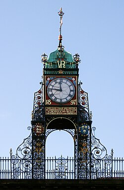
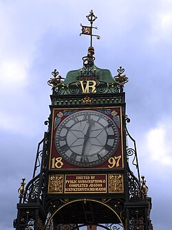
ประวัติศาสตร์
โครงการแรกในการปรับปรุงอีสต์เกตเกิดขึ้นหลังจากการเสด็จเยือนเมือง ของ เจ้าชายแห่งเวลส์ ในปี 1869 ในปี 1872 ฮิวจ์ โกรสเวเนอร์ซึ่งในขณะนั้นดำรงตำแหน่งมาร์ควิสแห่งเวสต์มินสเตอร์คนที่ 3 ได้ขอให้จอห์น ดักลาส สถาปนิกท้องถิ่น เตรียมแบบร่างหลายแบบ มาร์ควิสเสนอที่จะจ่ายครึ่งหนึ่งของค่าใช้จ่ายของโครงการ แต่คณะกรรมการปรับปรุงเชสเตอร์ไม่อนุญาตให้ใช้เงินทุนของสภาสำหรับโครงการนี้ และโครงการก็ล้มเหลว แนวคิดนี้ได้รับการฟื้นฟูขึ้นอีกครั้งเพื่อเฉลิมฉลองวาระครบ รอบ 60 ปี แห่ง การครองราชย์ของ สมเด็จพระราชินีนาถวิกตอเรียในปี 1896 ในเวลานั้นดยุคแห่งเวสต์มินสเตอร์คนที่ 1เสนอแนะว่าเมืองควรสนับสนุนสถาบันพยาบาลครบรอบการครองราชย์ของสมเด็จพระราชินีนาถวิกตอเรียแนวคิดอื่นๆ ที่เสนอในเวลานั้น ได้แก่ รูปปั้นของสมเด็จพระราชินีนาถวิกตอเรียในจัตุรัสศาลากลาง หรือนาฬิกาในหอคอยศาลากลาง[ 10 ]
มีการจัดตั้งคณะกรรมการขึ้น และถึงแม้จะได้รับการสนับสนุนในช่วงแรกสำหรับสถาบันควีนส์และงานเฉลิมฉลองทั่วไป แต่ในที่สุดก็ตัดสินใจที่จะสร้างหออนุสรณ์และนาฬิกาบนถนนอีสต์เกต จอห์น ดักลาสได้รับเชิญอีกครั้งให้เตรียมแบบร่าง แบบร่างแรกของเขาคือโครงสร้างหินที่มีราคา 1,000 ปอนด์ ( เทียบเท่ากับ 112,000 ปอนด์ในปี 2025 ) [ 11 ] อย่างไรก็ตาม แบบจำลองไม้แสดงให้เห็นว่าโครงสร้างนี้จะจำกัดแสงแดดสำหรับบ้านเรือนใกล้เคียง ในเดือนตุลาคม พ.ศ. 2440 การประชุมของผู้บริจาคเงินทุน (ซึ่งในขณะนั้นได้ระดมทุนได้เกือบ 651 ปอนด์ ( เทียบเท่ากับ 73,000 ปอนด์ในปี 2025 ) [ 11 ]ได้มีมติให้สร้างโครงสร้างเหล็กน้ำหนักเบาที่มีนาฬิกา จอห์น ดักลาสได้เตรียมแบบใหม่ ซึ่งได้รับการอนุมัติในเดือนมีนาคม พ.ศ. 2441 [ 10 ]
หน้าปัดและกลไกของนาฬิกาได้รับเงินสนับสนุนจากเอ็ดเวิร์ด อีแวนส์-ลอยด์ ทนายความท้องถิ่นและพลเมืองของเมืองในขณะที่ค่าใช้จ่ายในการสร้างหอคอยได้รับการสนับสนุนจากเงินบริจาคจากประชาชน และเทศบาลเมืองจะเป็นผู้รับผิดชอบค่าใช้จ่ายในการบำรุงรักษาในภายหลัง กลไกนาฬิกาถูกสร้างขึ้นในปี 1897 โดยบริษัทJB Joyce & Companyแห่งWhitchurch, Shropshireซึ่งจนถึงปี 1974 ได้ส่งช่างเทคนิคเดินทางมายังเชสเตอร์ทุกสัปดาห์เพื่อไขลานนาฬิกา จารึก เหล็กหล่อบนนาฬิกาทำโดยบริษัท Coalbrookdale Iron Company งานเหล็กสำหรับหอคอยทำโดยบริษัท James Swindley แห่งHandbridgeซึ่ง James Swindley เป็นลูกพี่ลูกน้องของ John Douglas พิธีเปิดนาฬิกาอย่างเป็นทางการจัดขึ้นในวันที่ 27 พฤษภาคม 1899 ซึ่งตรงกับวันคล้ายวันเกิดครบ 80 ปีของสมเด็จพระราชินีนาถวิกตอเรีย[ 10 ]
หลังจากที่นักล่าของที่ระลึกขโมยเข็มนาฬิกาไป สภาเมืองจึงได้เคลือบหน้าปัดนาฬิกาด้วยกระจกในปี 1988 ในปี 1992 กลไกไฟฟ้าได้เข้ามาแทนที่กลไกไขลานแบบเดิม ในปี 1996 หน้าปัดนาฬิกาได้รับการบูรณะด้วยสีดั้งเดิม กล่าวกันว่าเป็นนาฬิกาที่ถูกถ่ายรูปมากที่สุดในอังกฤษรองจากบิ๊กเบน[ 10 ]
สถาปัตยกรรม

นาฬิกาเรือนนี้มีหน้าปัดอยู่ทั้งสี่ด้าน และตั้งอยู่บน ฐาน เหล็กดัด ฉลุลาย ที่มีเสาโค้งมนอยู่ด้านข้างแต่ละด้านฐาน ของ นาฬิกามีจารึกอยู่บนแต่ละด้าน จารึกด้านตะวันออกอ่านว่า "หอนาฬิกาแห่งนี้สร้างขึ้นเพื่อเป็นอนุสรณ์ในวาระครบรอบ 60 ปีแห่งการครองราชย์ของพระราชินีวิกตอเรีย" ด้านตะวันตกอ่านว่า "ANTIQUI COLANT ANTIQUUM DIERUM: BC ROBERTS, นายกเทศมนตรี 1897; JC HOLMES, นายกเทศมนตรี 1898" ด้านใต้อ่านว่า "นาฬิกาเรือนนี้สร้างขึ้นโดย EDWARD EVANS-LLOYD พลเมืองและผู้มีเกียรติ 1897" และด้านเหนืออ่านว่า "สร้างขึ้นโดยการบริจาคจากประชาชนและแล้วเสร็จ ค.ศ. 1899 H. STOLTEFORTH นายกเทศมนตรี" ใต้หน้าปัดนาฬิกาแต่ละอันที่เคลือบทองจะมีวันที่ 1897 และเหนือหน้าปัดแต่ละอันจะมีอักษรย่อ "VR" ที่เคลือบทองเช่นกัน เหนือนาฬิกามีโดม ทองแดงรูปทรง โค้ง มน ซึ่งมีกังหันลมรูปสิงโตยืนสองขาบนพื้นหลังสีแดงอยู่ด้านบน[ 1 ]
ดูเพิ่มเติม
ลิงก์ภายนอก

- Eastgate กับ 'Chester: a Virtual Stroll Around the Walls'
- เจบี จอยซ์ - ช่างทำนาฬิกาคนแรกของ "นาฬิกาอีสต์เกต"
- ภาพ 360° จาก Google StreetView ของนาฬิกาอีสต์เกต
53°11′27″N 2°53′20″W / 53.19088°N 2.8888246°W / 53.19088; -2.8888246