
Pont-Audemer
Pont-Audemer | |
|---|---|
 Pont-Audemer: Rue de la République | |
 Coat of arms | |
 Location of Pont-Audemer | |
  Pont-Audemer  Pont-Audemer | |
| Coordinates: 49°21′23″N00°30′56″E / 49.35639°N 0.51556°E / 49.35639; 0.51556 | |
| Country | France |
| Region | Normandy |
| Department | Eure |
| Arrondissement | Bernay |
| Canton | Pont-Audemer |
| Intercommunality | Pont-Audemer / Val de Risle |
| Government | |
| • Mayor (2022–2026) | Alexis Darmois[1] |
Area 1 | 14.66 km2 (5.66 sq mi) |
| Population (2023)[2] | 10,023 |
| • Density | 683.7/km2 (1,771/sq mi) |
| Time zone | UTC+01:00 (CET) |
| • Summer (DST) | UTC+02:00 (CEST) |
| INSEE/Postal code | 27467 /27500 |
| Elevation | 2–115 m (6.6–377.3 ft) (avg. 9 m or 30 ft) |
| 1 French Land Register data, which excludes lakes, ponds, glaciers > 1 km2 (0.386 sq mi or 247 acres) and river estuaries. | |
Pont-Audemer (French pronunciation:[pɔ̃.t‿odmɛʁ]) is a commune in the Euredepartment in the Normandyregion in northern France.[3] On 1 January 2018, the former commune of Saint-Germain-Village was merged into Pont-Audemer.[4]
Geography
The commune is situated on the river Risle, 13 km upstream from its outflow into the Seine. It lies on the border between the regions Roumois and Lieuvin.
The commune along with another 69 communes shares part of a 4,747 hectare, Natura 2000 conservation area, called Risle, Guiel, Charentonne.[5]
Population
The population data in the table below refer to the commune of Pont-Audemer proper, in its geography at the given years. The commune of Pont-Audemer absorbed part of the former commune of Saint-Aignan in 1835, Saint-Paul-sur-Risle in 1963 and Saint-Germain-Village in 2018.[6][4]
ประชากรในอดีต | ||||||||||||||||||||||||||||||||||||||||||||||||||||||||||||||||||||||||||||||||||||||||||||||||||||||||||||||||||||||
|
| |||||||||||||||||||||||||||||||||||||||||||||||||||||||||||||||||||||||||||||||||||||||||||||||||||||||||||||||||||||
| แหล่งที่มา: EHESS [ 6 ]และ INSEE (2007-2023) [ 7 ] [ 8 ] [ 9 ] | ||||||||||||||||||||||||||||||||||||||||||||||||||||||||||||||||||||||||||||||||||||||||||||||||||||||||||||||||||||||
สถานที่ท่องเที่ยว
ชุมชนแห่งนี้รอดพ้นจากความเสียหายอย่างหนักต่ออาคารเก่าแก่ในระหว่างยุทธการนอร์มังดีปัจจุบัน อาคาร ไม้ครึ่งหลังและคลองที่ไหลผ่านระหว่างอาคารเหล่านั้นกลายเป็นแหล่งท่องเที่ยว โบสถ์แซงต์-โอวองมีชื่อเสียงในด้านกระจกสีสมัยเรเนซองส์
บุคลิกภาพ
- ลาเอทิเทีย คาสตาซูเปอร์โมเดลชื่อดัง เกิดที่นั่นในปี 1978
- Delphine Philippe-Lemaîtreนักประวัติศาสตร์และนักโบราณคดีในศตวรรษที่ 19
- แอร์เว โมแร็งนักการเมืองและอดีตรัฐมนตรีว่าการกระทรวงกลาโหมของฝรั่งเศส เกิดที่นั่นในปี 1961
- อเล็กซิส วาสทีนนักมวย เกิดที่นั่นในปี 1986
ขนส่ง
ปงต์-โอเดอแมร์มีสถานีรถไฟชื่อGare de Pont-Audemerแต่ได้ยุติการให้บริการรถไฟโดยสารในปี 1969 ปัจจุบันสถานีนี้ให้บริการโดยรถโดยสารประจำทางTER Haute-NormandieสมาคมรถไฟโบราณPontAuRail เคยให้บริการ รถไฟดีเซลแบบหลายตู้ ( X4500และX2400 ) สองขบวนจากปงต์-โอเดอแมร์ไปยังฮอนเฟลอร์ระหว่างปี 1995 ถึง 2006
การบริหาร
จนถึงปี 1926 เมืองปงต์-โอเดอแมร์เป็นเมืองรองของจังหวัดเออเร
สื่อ
เมืองนี้ถูกกล่าวถึงในบทกวีของปอล แวร์แลนชื่อ "อพอลโลแห่งปงต์-โอเดอแมร์" และยังถูกกล่าวถึงในหนังสือของเท็ด ฟาห์เรนวาลด์ เรื่อง "Bailout Over Normandy: A Flyboy's Adventures" ในฐานะสถานที่ที่เขาได้พบกับริริ คนรักของเขา
เมืองคู่แฝดและเมืองพี่น้อง
เมืองปงต์-โอเดอแมร์มีเมืองคู่แฝดกับ:


แกลเลอรี่
 สถานที่ของหลุยส์ กิลเลน
 อนุสรณ์สถานสงคราม
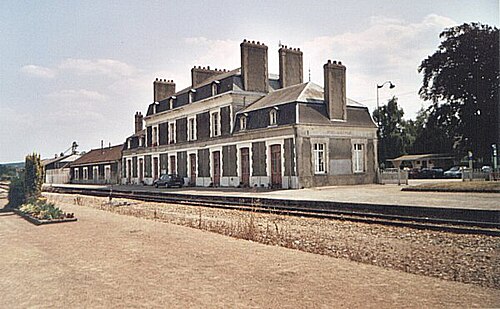 สถานีรถไฟ
 รถเมล์สาย X2426 ที่สถานี Pont-Audemer