อ่าน 3 นาที
Purathur
Purathur is a sandy coastal village and a Grama Panchayat in Tirur Taluk , Malappuram district in the state of Kerala , India.
Purathur
Purathur | |
|---|---|
Village | |
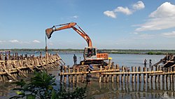 Padinjarekara Azhimukham at Purathur where the river Bharathappuzha and Tirur River merge together and empties into Arabian Sea (Opposite side is Ponnani port) | |
 Purathur Location in Kerala, India | |
| Coordinates: 10°48′08″N75°55′21″E / 10.80222°N 75.92250°E | |
| Country | |
| State | Kerala |
| District | Malappuram |
| Established | December - 1964 |
| Government | |
| • Body | Panchayath |
| Area | |
• Total | 19.15 km2 (7.39 sq mi) |
| Population (2011) | |
• Total | 31,915 |
| • Density | 1,667/km2 (4,316/sq mi) |
| Languages | |
| • Official | Malayalam, English |
| Time zone | UTC+5:30 (IST) |
| PIN | 676102 & 676561 |
| Telephone code | 0494-256 |
| Vehicle registration | KL-55 |
Purathur is a sandy coastal village and a Grama Panchayat in Tirur Taluk, Malappuram district in the state of Kerala, India.[1]Bharathappuzha river and Tirur River merges together in Purathur and join with the Arabian Sea at Padinjarekara Azhimukham, which is also the southernmost tip of Purathur Gram panchayat. Opposite to Padinjarekara Azhimukham is Ponnani port.[2] The village is located at the southernmost tip of Tirur Taluk and is bordered by historically important Ponnani port in Ponnani Municipality of Ponnani taluk to south (Opposite to Padinjarekara Azhimukham).[2]
Geography
Purathur Grama Panchayat is bounded by waterbodies.[2] It is bounded by Arabian Sea to west, and Bharathappuzha River to southeast and south.[2] On north, it is bounded by Mangalam Grama panchayat, and on the east by Triprangode Grama panchayat.[2] The Tirur River, which passes through middle of village, separates the village into two parts - a coastal area and an inland area. Mangroves are widely seen in the coastal area.[2] Migratory Birds also arrive here.[2] A bird sanctuary at Purathur was proposed in 2010.[3]
Demographics
As of 2011 India census, Purathur village had a population of 31,915, of whom 15,062 were males while 16,853 were females. The population of children aged 0–6 was 4,290, which made up 13.44% of the total population of the village. The average sex ratio of Purathur village was 1,119, higher than the Kerala state average of 1,084. The child sex ratio for Purathur was 1,008, higher than the Kerala average of 964.[4]
Wards

Purathur Grama Panchayat is composed of the following 20 wards:[5]
| Ward no. | Name | Ward no. | Name |
|---|---|---|---|
| 1 | Pandazhi | 2 | Muttannur |
| 3 | Muttannur East | 4 | Chirakkal |
| 5 | Maravantha | 6 | Athanipadi |
| 7 | Puthuppalli | 8 | Kuttikkad |
| 9 | Thrithaloor South | 10 | Ezhipadam |
| 11 | Kaloor | 12 | Munambam |
| 13 | Purathur | 14 | Kavilakkad South |
| 15 | Kavilakkad | 16 | Thrithallur |
| 17 | Edakkanad | 18 | Azhimukham |
| 19 | Padinjarekkara | 20 | Pandazhi |
Border local bodies
- East - Triprangode Panchayath, Bharathappuzha (Ponnani Municipality)[2]
- West - Arabian Sea[2]
- South - Bharatha puzha (Ponnani Municipality)[2]
- North - Mangalam and Thripangode panchayaths[2]
Transportation
Purathur village connects to other parts of India through Kuttippuram town and Chamravattam. National highway No. 66 passes through Edappal and the northern stretch connects to Goa and Mumbai. The southern stretch connects to Cochin and Trivandrum. National Highway No. 966 connects to Palakkad and Coimbatore. Another connection point is Chamravattom, 4 km away from Purathur.
KSRTC buses run between Ernakulam-Malappuram, Tirur-Ponnani, Calicut-Guruvayur, Calicut-Ernakulam, Calicut-Alleppey, Calicut-Thiruvananthapuram, and Ponnani-Bangalore. A large number of KSRTC buses including super fast passenger, super fast, town-to-town, limited stop and ordinary buses run through Chamravattam.
The nearest airport is at Karippur (Kozhikode).
The nearest major railway station is located at Tirur.
Temples

The HinduBhayankavu Bhagavathi Temple is the major temple in Purathur village. It is a sacred Bhagavathi temple on the Alathiyoor Pallikadavu Road in Edakkanad, about 14 km from Tirur town.
วัดแห่งนี้สร้างขึ้นเพื่ออุทิศแด่เทพีภควตี มีเทศกาลสำคัญสามเทศกาลที่จัดขึ้นในภยันกาวู เทศกาลแรกคือวันที่ 1 ธูลัม (กลางเดือนตุลาคม) เทศกาลที่สองคือเทศกาลมาการาโชววา (วันอังคารที่สองของเดือนมาการัมในปฏิทินมาลายาลัม) และพิธีกรรมทาลัปโปลีประจำปีที่จัดขึ้นในวัดตามปฏิทินมาลายาลัมในเดือนกุมภัม
การท่องเที่ยว
ถนน ติรุร์- กูตายีสิ้นสุดที่ปาดินจาเรการา (ปุราธุร) หรือที่รู้จักกันดีในชื่อ ปาดินจาเรการา อะซีมูฆัม ซึ่ง เป็นจุดที่แม่น้ำ ภารตะปุซาและแม่น้ำติรุร์มาบรรจบกันก่อนไหลลงสู่ทะเล สถานที่แห่งนี้ขึ้นชื่อเรื่องนกอพยพที่มารวมตัวกันเป็นพันๆ ตัวในช่วงเดือนกุมภาพันธ์ถึงเมษายน ชายหาดแห่งนี้อยู่ใกล้กับติรุร์และขึ้นชื่อเรื่องทิวทัศน์ที่สวยงาม ชายหาดแห่งนี้เป็นจุดหมายปลายทางของนักท่องเที่ยวทั้งในและต่างประเทศ รวมถึงผู้รักธรรมชาติมาอย่างยาวนาน
ดูเพิ่มเติม
สรุปเนื้อหา
ข้อมูลสำคัญจากบทความ
ข้อมูลสำคัญเกี่ยวกับ Purathur
Purathur is a sandy coastal village and a Grama Panchayat in Tirur Taluk , Malappuram district in the state of Kerala , India.
Geography
Purathur Grama Panchayat is bounded by waterbodies. [ 2 ] It is bounded by Arabian Sea to west, and Bharathappuzha River to southeast and south. [ 2 ] On north, it is bounded by Mangalam Grama panchayat, and on the east by Triprangode Grama panchayat.
Demographics
As of 2011 India census , Purathur village had a population of 31,915, of whom 15,062 were males while 16,853 were females. The population of children aged 0–6 was 4,290, which made up 13.44% of the total population of the village.
Wards
Purathur Grama Panchayat is composed of the following 20 wards: [ 5 ]