
หมู่เกาะชิแอนท์
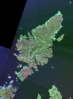
หมู่เกาะชีอันต์[ 1 ] ( / ʃ æ n t / ; ภาษาเกลิคแบบสก็อตแลนด์ : Na h-Eileanən Mòra [nə ˈhelanən ˈmoːɾə]หรือNa h-Eileanan Seunta [nə ˈhelanən ˈʃiant̪ə]ⓘ ) หรือหมู่เกาะชิแอนท์กลุ่มเกาะที่เป็นกรรมสิทธิ์ส่วนตัวในช่องแคบมินช์ทางตะวันออกของเกาะแฮร์ริสในหมู่เกาะเอาเตอร์เฮบริดีสเกาะลูอิสใต้5 ไมล์ (8 กิโลเมตร) [ 2 ]
นิรุกติศาสตร์
ชื่อShiantมาจากภาษาเกลิกของสกอตแลนด์Na h-Eileanan Seuntaซึ่งอาจหมายถึง "หมู่เกาะที่มีเสน่ห์" "ศักดิ์สิทธิ์" หรือ "หมู่เกาะต้องมนต์" แต่มีความเป็นไปได้มากกว่าที่ชื่อนี้จะมาจากคำศัพท์ทางทะเลของชาวนอร์ส โดยน่าจะเป็น sjóund ซึ่งหมายถึง "ช่องทะเล / อ่าว / รอยแยก" ต่อมาได้ถูกปรับเปลี่ยนในภาษาเกลิกเป็น seunta ซึ่งคล้ายกับคำคุณศัพท์ในภาษาเกลิก และถูกตีความใหม่ผ่านทางนิรุกติศาสตร์พื้นบ้านและวรรณกรรมโรแมนติกให้หมายถึง "ต้องมนต์" ชื่อในภาษานอร์สโบราณน่าจะเป็น Sundeyjar ซึ่งหมายถึง 'หมู่เกาะแห่งช่องแคบ' กลุ่มเกาะนี้ยังเป็นที่รู้จักในชื่อNa h-Eileanan Mòraซึ่งหมายถึง "หมู่เกาะใหญ่" เกาะหลักๆ ได้แก่Garbh Eilean ("เกาะขรุขระ") และEilean an Taighe ("เกาะบ้าน") ซึ่งเชื่อมต่อกันด้วยคอคอด แคบๆ และEilean Mhuire ("เกาะของพระแม่มารี") ทางทิศตะวันออก Eilean an Taighe ถูกเรียกว่าEilean na Cille ("เกาะของโบสถ์") ก่อนศตวรรษที่ 19 [ 3 ] [ 4 ] [หมายเหตุ 1 ]
แผนที่ในศตวรรษที่ 17 โดย John Adair และแผนที่อื่นๆ ในศตวรรษที่ 18 เรียก Garbh Eilean ว่าเกาะ Nunaltins , Eilean Mhuire ว่าเกาะ St Marysและ Eilean an Taighe ว่า เกาะ St Columbsชื่อสุดท้ายนี้บ่งชี้ว่าโบสถ์บนเกาะ Eilean an Taighe อาจอุทิศให้กับนักบุญโคลัมบา ความหมายของNunaltinsยังไม่ชัดเจน แต่อาจมาจากภาษาเกลิกที่แปลว่าเกาะแห่งลำธาร[ 6 ]
ภูมิศาสตร์และธรณีวิทยา
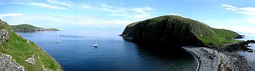
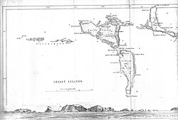
The Shiant Islands lie east of the Sound of Shiant. Garbh Eilean and Eilean an Taighe together extend to 143 hectares (350 acres);[3] the much more fertile Eilean Mhuire extends to 75 hectares (190 acres).[7] In addition to these main islands, there is a line of Galtachan rocks that lie to the west: Galta Beag, Bodach, Staca Làidir, Galta Mòr, Sgeir Mhic a' Ghobha and Damhag.[8]
Geologically, these islands are an extension of the Trotternish peninsula of Skye. Their rocks are volcanic, and, at 60 million years old, very young compared with other Hebridean rocks. Dolerite columns on the north side of Garbh Eilean are over 120 metres (390 feet) tall and about 2 m (6 ft 7 in) in diameter. They are much higher in places than those at Staffa and the Giant's Causeway, but similar in that they were formed by the slow cooling of volcanic rocks deep underground.[3][9] Intrusive sills exhibit a progression in their chemical compositions, from olivine-rich rocks at the base, to rocks with very little or no olivine at the top.
The sills are thought to have been formed by crystal settling. Recent study has suggested that at least one of the sills is an example of a multiple intrusion.[10] In some places, the basalt is overlain by Jurassic mudstone, which weathers to form much more fertile soil than is present elsewhere in the Western Isles.
The islands can be visited by means of various cruise ships that operate from other Hebridean Islands and from mainland Scotland. Small boat (RIBs) tours out to the islands are also run by operators from the Outer Hebrides.

History

In 1549, Donald Monro, Dean of the Isles wrote in Scots of:
"an isle called Ellan Senta, which means in English "fable island", an isle more than two miles [three kilometres] long, very profitable for grain, stock-rearing and fishing, pertaining to McLeod of Lewis. On the east side of this isle there is a bore, made like a vault, longer(?) than the arrow shot of any man on earth, through which gulping vault we used to row our sail boats, for fear of the horrible break of the seas that is on the outward side, but no large ship can sail through it." Nicolson (2002) calls this "vault" on Toll a' Roimh at the north east end of Garbh Eilean the "Hole of the Seals" and describes rowing a dinghy through it.[11][12][Note 2]

A century and a half later, in 1703, Martin Martin wrote that
the two southern islands are separated only by spring-tides, and are two miles [3 km] in circumference. Island-More hath a chapel in it dedicated to the Virgin Mary, and is fruitful in corn and grass; the island joining to it on the west is only for pasturage.[14][Note 3]
At the beginning of the twentieth century, the Shiant Islands were home to only eight people.[2] The author and politician Compton MacKenzie owned the islands from 1925 until 1937. He was an island lover who, at different points in his life, also occasionally rented Herm in the Channel Islands. He never lived on the Shiants, but paid several brief visits there during his time as owner.[2]
In 1937, the islands were purchased by Nigel Nicolson, then an undergraduate at Oxford, using money that had been left to him by his grandmother. Nicolson later became a writer, publisher and politician, as MacKenzie had been. Nicolson's son, the writer Adam Nicolson, published the definitive book on the islands, Sea Room (2001). Today, the Shiants belong to Adam's son, Tom Nicolson. Sheep continue to graze the islands, as they have done since the mid-19th century. The simple cottage maintained by the Nicolson family on Eilean an Taighe is the only habitable structure on any of the islands.[16] In 2012, Robert Macfarlane published, in The Old Ways, a description of his visit to the islands.[17]
Wildlife

หมู่เกาะ Shiant มีประชากรนกทะเล จำนวนมาก รวมถึง นกพัฟฟินแอตแลนติกหลายหมื่นตัวที่ผสมพันธุ์ในโพรงบนเนินเขาของ Garbh Eilean และนกกีลเลมอทธรรมดานกเรเซอร์บิล นกฟุลมาร์เหนือ นกคิตติเวคขาดำนก ชา กธรรมดานกนางนวลและนกสกัวใหญ่ จำนวนมาก (มีนกพัฟฟินบน Garbh Eilean น้อยกว่าบนเกาะSt Kilda ที่ห่างไกล แต่พวกมันรวมตัวกันหนาแน่นกว่ามาก) [ 9 ] [ 19 ]
จนกระทั่งเมื่อไม่นานมานี้ เกาะเหล่านี้ยังเป็นที่อยู่อาศัยของประชากรหนูสีดำ Rattus rattusซึ่งสันนิษฐานว่าเดิมทีขึ้นฝั่งมาจากเรืออับปาง[ 20 ]นอกเหนือจากเกาะเล็กๆ หนึ่งหรือสองเกาะในอ่าวเฟิร์ธออฟฟอร์ธแล้วหมู่เกาะเชียนต์เป็นเพียงสถานที่เดียวในสหราชอาณาจักรที่ยังคงพบหนูสีดำ (หรือหนูเรือ) ได้[ 21 ]เชื่อกันว่ามีประชากรหนูประมาณ 3,500 ตัวบนเกาะในช่วงฤดูหนาว โดยจำนวนของพวกมันเพิ่มขึ้นอย่างรวดเร็วในช่วงฤดูร้อน การวิเคราะห์เนื้อหาในกระเพาะของพวกมันแสดงให้เห็นว่าพวกมันกินนกทะเล แต่ไม่สามารถระบุได้ว่าพวกมันล่าเหยื่อเป็นนกที่ยังมีชีวิตอยู่หรือเพียงแค่กินซากนกที่ตายแล้ว[ 22 ] (จำนวนของพวกมันได้รับการควบคุมอย่างดีในและรอบๆ บ้านมาเป็นเวลาหลายปีแล้ว) [ 23 ]
ในช่วงฤดูหนาวปี 2015–2016 บริษัท Wildlife Management International Limited ได้ริเริ่มโครงการกำจัดหนูออกจากเกาะ Shiant อย่างถาวร ซึ่งเป็นส่วนหนึ่งของโครงการฟื้นฟูประชากรนกทะเลในเกาะ Shiant โครงการนี้ได้รับทุนสนับสนุนจากสหภาพยุโรป SNH, RSPB และผู้บริจาครายบุคคลจำนวนมาก[ 24 ] [ 25 ] [ 26 ]ในเดือนมีนาคม 2018 เกาะ Shiant ได้รับการพิจารณาว่าได้ดำเนินการกำจัดหนูตามระยะเวลาสองปีที่ตกลงกันไว้ในระดับนานาชาติเสร็จสิ้นอย่างน่าพอใจ และได้รับการประกาศอย่างเป็นทางการว่าปลอดหนูแล้ว[ 27 ]
น่านน้ำรอบเกาะชิแอนท์เป็นแหล่งอาศัยของสัตว์ทะเลหลากหลายชนิด รวมถึงแมวน้ำสีเทาและแมวน้ำท่าเรือ[ 28 ]วาฬฟิน วาฬเพชฌฆาต โลมา ฉลามบาสกิ้ง และปลาโลมา[ 29 ]
ดูเพิ่มเติม
ลิงก์ภายนอก
- เว็บไซต์เกี่ยวกับหมู่เกาะเชียนต์
57°54′เหนือ6°22′ตะวันตก / 57.90°เหนือ 6.36°ตะวันตก