
Sullivan Bay, Victoria
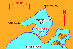
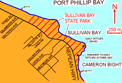

Sullivan Bay lies 60 km (37 mi) due south of Melbourne on Port Phillip, one kilometre (0.6 mi) east of Sorrento, Victoria. It was established as a short-lived convict settlement in 1803 by Lieutenant-Colonel David Collins,[1] who named the bay after the Under-Secretary of State for War and the Colonies, John Sullivan.
The site was chosen because of its strategic location near the entrance of Port Phillip Bay. The settlement is significant because it was the first attempt to settle Europeans permanently in what is now Victoria and was a key link in the expansion of the colony of New South Wales into Tasmania and Victoria, and the control of Bass Strait as a trade route.
History
In 1802, Lieutenant John Murray discovered Port Phillip Bay and claimed it for the British Crown, and Matthew Flinders further explored the area that same year. The British government was impressed with their positive reports, and were also worried that the French might try to establish colonies there.
They decided to get in first. In April 1803 HMS Calcutta and the transport ship Ocean sailed from England, via the Cape of Good Hope, carrying officers, a marine detachment, free settlers, and 301 convicts to Port Phillip, and some wives and children. They arrived on 10 October 1803.
Shortly after arriving, a party led by James Tuckey was dispatched to explore Port Phillip Bay. They reported that the land was poor and there was little fresh water even though the Yarra and Maribyrnong Rivers had been discovered on 2 January 1803 by Charles Grimes' party,[2] months before the arrival of the Sullivans Bay colonists. They also reported that suitable timber could not be found. The treacherous entrance to the bay made the site unsuitable for whaling and with few marines, the settlement was vulnerable to attack.
คอลลินส์ขออนุญาตผู้ว่าการคิงเพื่อละทิ้งสถานที่นั้น และในที่สุดก็ได้รับอนุญาต ในวันที่ 30 มกราคม ค.ศ. 1804 คอลลินส์และนักโทษบางส่วนออกเดินทางโดยเรือโอเชียนและเลดี้เนลสันไป ยัง แวนไดเมนส์แลนด์ (ปัจจุบันคือแทสเมเนีย ) ซึ่งจอห์น โบเวนได้ก่อตั้งถิ่นฐานที่ริสดันโคฟในปี ค.ศ. 1803 พวกเขาถูกย้ายไปเป็นสองกลุ่ม กลุ่มที่สองออกเดินทางในวันที่ 20 พฤษภาคม เพียงเจ็ดเดือนกว่าๆ หลังจากที่ถิ่นฐานถูกก่อตั้งขึ้น บันทึกแสดงให้เห็นว่ามีผู้เสียชีวิตในถิ่นฐานนั้น 30 คน
ระหว่างการยึดครองระยะสั้น นักโทษ 21 คนหลบหนี[ 3 ] หนึ่งในนั้นคือวิลเลียม บักลีย์ซึ่งอาศัยอยู่ในบริเวณรอบๆจีลองเป็นเวลา 33 ปี ก่อนที่จะได้พบกับ คณะของ จอห์น แบทแมนในปี พ.ศ. 2378
หลักฐานการตั้งถิ่นฐานเหลือน้อยมาก มีเพียงหลุมฝังศพสี่หลุมบนแหลมทางทิศตะวันออก และเศษถัง โซ่ตรวน ขวด และชิ้นส่วนอื่นๆ เท่านั้นที่ยังหลงเหลืออยู่[ 4 ]เขตอนุรักษ์ประวัติศาสตร์การตั้งถิ่นฐานคอลลินส์ ซึ่งประกอบด้วยแนวชายฝั่งยาวประมาณ 2 กิโลเมตร (1.2 ไมล์) ได้รับการคุ้มครองภายใต้ทะเบียนมรดกวิกตอเรียและแผนผังการวางแผนคาบสมุทรมอร์นิงตัน[ 5 ]
อ่านเพิ่มเติม
- มาร์จอรี ทิปปิง. นักโทษผู้ไร้พันธนาการ: เรื่องราวของนักโทษจากกัลกัตตาและการตั้งถิ่นฐานในออสเตรเลียเซาท์ ยาร์รา รัฐวิกตอเรีย สำนักพิมพ์ไวกิ้ง โอ'นีล, 1988
- Crook, William Pascoe, (1983), บันทึกเกี่ยวกับการตั้งถิ่นฐานที่อ่าวซัลลิแวน พอร์ตฟิลลิป ค.ศ. 1803 (บรรณาธิการ John Currey) สำนักพิมพ์ The Colony Press, เมลเบิร์น
- Bonwick, James, (1883), Port Phillip Settlement , Samson, Low, Marston, Searle & Rivington Publishing, London.
- Angell, B, (1984), การเดินทางสู่พอร์ตฟิลลิป ค.ศ. 1803 , สมาคมประวัติศาสตร์นีเพียน, ซอร์เรนโต
- คอตเตอร์, ริชาร์ด (2001) ไม่มีที่ใดเหมาะสมสำหรับการตั้งอาณานิคม: อ่าวซัลลิแวน, ซอร์เรนโต และการตั้งถิ่นฐานของคอลลินส์
- Coutts, JF (1981) การตั้งถิ่นฐานอย่างเป็นทางการแห่งแรกของรัฐวิกตอเรีย: อ่าวซัลลิแวน, พอร์ตฟิลลิปสำรวจโบราณคดีรัฐวิกตอเรีย กระทรวงการอนุรักษ์
38°20′52″ส144°45′38″จ / 38.34778°S 144.76056°E