
ทาโปวาน่า
คำว่า Tapovana (ภาษาสันสกฤต) มาจากรากศัพท์สองคำ คือ tapasซึ่งหมายถึง 'การบำเพ็ญเพียร' และโดยนัยหมายถึง 'การทรมานตนเองทางศาสนา' และ 'การถือศีลอย่างเคร่งครัด' และโดยทั่วไปหมายถึง 'การปฏิบัติทางจิตวิญญาณ' และ vanaซึ่งหมายถึง 'ป่า' หรือ 'พุ่มไม้' ดังนั้น Tapovanaจึงแปลว่า 'ป่าแห่งการถือศีลอย่างเคร่งครัดหรือการปฏิบัติทางจิตวิญญาณ' แม้ว่าจะออกเสียงเหมือนกันในภาษาฮินดี แต่ไม่ควรสับสนTapovanatapovan(จากtapovat) ซึ่งหมายถึงบุคคลที่ถือศีลอย่างเคร่งครัด
ตามประเพณีในอินเดีย สถานที่ใดก็ตามที่ผู้คนได้บำเพ็ญภาวนาอย่างจริงจัง อาจกลายเป็นที่รู้จักในชื่อทาโปวานาแม้ว่าจะไม่มีป่าอยู่ก็ตาม นอกจากถ้ำและที่พำนักของฤๅษีและสาธุชน แล้ว ยังมีบางสถานที่ เช่น ฝั่งตะวันตกของแม่น้ำคงคา ตอนเหนือ บริเวณ ริชิเกศที่ฤๅษีใช้เป็นที่พำนัก จนพื้นที่ทั้งหมดกลายเป็นที่รู้จักในชื่อทาโปวานา
ทาโปวัน (สถานที่)

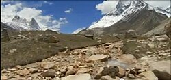
The most well known tapovan in India is the area above the Gangotri Glacier at one of the primary sources of the Ganges, in Uttarakhand, India. At the foot of Shivling peak, a barren area at about 4,463m (14640 feet) elevation, is a seasonal home to several sadhus living in caves, huts, etc. and it has become a trekking destination also.[1] The trekking usually starts from Gomukh and the trek was considered moderate to difficult[1] prior to the destruction of much of the trail from Gangotri to Gaumukh by the 2013 North Indian Floods. The Tapovan area is base camp for several mountaineering expeditions including Shivling peak, Bhagirathi peak etc. The Tapovan area is full of meadows, streams and flowering plants and the meadows are considered one of the best high altitude meadows in India. In Tapovan, a stream named Amrit Ganga – the nectar of the Ganges – flows into the glacier.[1] There is also a place named Nandanvan near Tapovan, and Nandanvan is also trekked by trekkers and pilgrims.[1] Nandanvan is also a spacious meadow located at the base of Bhagirathi massif.[2]
There is a place bearing a similar name at Joshimath in Chamoli District, which has a sulphur spring known as the Tapovan Hot Springs. It is a part of the Sapta BadriTapovan PDF.
See also
 | This Hinduism-related article is a stub. You can help Wikipedia by adding missing information. |